Tenino, Washington
This article's lead section may be too short to adequately summarize the key points. (June 2020) |
Tenino, Washington | |
|---|---|
City | |
 Downtown Tenino, along Sussex Street, 2011 | |
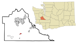 Location of Tenino, Washington | |
| Coordinates: 46°51′24″N 122°51′1″W / 46.85667°N 122.85028°WCoordinates: 46°51′24″N 122°51′1″W / 46.85667°N 122.85028°W | |
| Country | United States |
| State | Washington |
| County | Thurston |
| Area | |
| • Total | 1.46 sq mi (3.77 km2) |
| • Land | 1.46 sq mi (3.77 km2) |
| • Water | 0.00 sq mi (0.00 km2) |
| Elevation | 289 ft (88 m) |
| Population | |
| • Total | 1,695 |
| • Estimate (2019)[2] | 1,865 |
| • Density | 1,280.91/sq mi (494.66/km2) |
| Time zone | UTC-8 (Pacific (PST)) |
| • Summer (DST) | UTC-7 (PDT) |
| ZIP code | 98589 |
| Area code | 360 |
| FIPS code | 53-70630 |
| GNIS feature ID | 1512718[4] |
| Website | https://cityoftenino.us/ |

Tenino (/təˈnaɪnoʊ/) is a city in Thurston County, Washington, United States. The population was 1,695 at the 2010 census.[5]
History[]
Tenino was officially incorporated on July 24, 1906, though it existed as a rural community since the mid-19th century. Initially, American settlers were attracted to the open prairies created and maintained by local natives through controlled burns to cultivate camas root, a staple food source. Records indicate the initial settlers' community centered on the prairie approximately 1/2 mile south of the present town. Early residents named their first post office and school "Coal Bank", in the 1860s, a reference to a nearby coal outcropping.[6] It was later renamed Tenino.
In the late 19th century, a number of sandstone quarrying companies began shipping building stone, used in many regional buildings outside of Tenino, including the Old Capitol Building and the old Thurston County Courthouse in Olympia, the Mason County Courthouse in Shelton, Washington, the First Congregational Church, developed by Cameron Stone, in Tacoma, Washington, Denny Hall and the Theodore Jacobson Observatory at the University of Washington, Seattle, the Pittock Mansion and the Pioneer Courthouse in Portland, Oregon, the Calvary Presbyterian Church (San Francisco) and several US post office buildings, including at The Dalles, Oregon. The US Government also used stone from these quarries to construct jetties at Westport, Washington and elsewhere. The quarries declined in the early 20th century when many builders switched to concrete.
In addition to quarrying, logging, saw mills, and coal mining were also well established industries in the area. However, as the timber played out and railroads switched to diesel in the mid-20th century, these industries also declined.

Tenino briefly achieved national fame during the Great Depression. After the local bank closed, the town government temporarily issued wooden money scrip for use locally when cash was scarce.[7] However, most of the wooden money was never redeemed as it became a collector's item.[8] Tenino began printing the wooden currency during the COVID-19 recession in 2020 to distribute to residents.[9] The revival of the program was approved by the Washington State Auditor and began in May 2020.[10][11]
In the years before the construction of Interstate 5, Tenino gained a reputation as a notorious stretch along U.S. Route 99. Many motorists considered it a speed trap because of the strict enforcement by police of the abruptly reduced speed limit through town.[12]
While Tenino retains its historic downtown, now a historic district listed on the National Register of Historic Places, the town serves largely as a "bedroom community", many of its citizens commuting by car to larger cities such as Olympia and Tacoma for work.
Since the mid-1970s, the US Army has used a geographical map of Tenino as a training aid in map reading, because of the variety of symbols represented on the map.
Name origin[]
The origin of the name Tenino, used by the Northern Pacific Railroad for their station when they arrived in 1872, has been debated for over a century.
Recent research published in The Naming of Tenino by the Tenino City Historian, Rich Edwards, chronicles the visit of the Pacific Coast Committee in early October 1872. This committee, including railroad President Cass, traveled up the Columbia River on steamboats of the Oregon Steam Navigation Company. Earlier that year, the Northern Pacific Railroad had purchased controlling interest in the OSN as part of their goal to connect their Kalama to Puget Sound line, then under construction, to their transcontinental railroad being built westward from Minnesota.[13]
On October 12, 1872, at a meeting in Portland, Oregon where John Ainsworth and other officers of the OSN made a presentation about their common interests, President Cass proposed a resolution that named the momentarily Northern terminus near Hodgden's station "Tenino".
As reported the following month in an Olympia, Washington, newspaper, this connection allowed travel from the "old Tenino" (the OSN steamboat operating on the upper reaches of the Columbia and Snake Rivers as far as Lewiston, Idaho), to "the new town" of Tenino which was the railroad's then current northwest terminus.[14]
In early 1873 the Northern Pacific Railroad and local homesteader Stephen Hodgden filed plats in Thurston county establishing the town of Tenino. By late 1873, the financial backing of the railroad was in financial crisis and their stock in the OSN was sold for debt, ending the railroad's direct connection to the steamboat Tenino.
The steamboat Tenino was itself named after the Tenino native band who once lived near The Dalles in Oregon and whose descendants are now part of the Confederated Tribes of Warm Springs.
With the influx of people in Tenino in the 1890s, due to the opening of thriving sandstone quarries, the question of the origin of the name arose. With the steamboat on the distant river gone and long forgotten, locals created mythical stories about its origins. By the early twentieth century, the press were referring to the origin of the name as a mystery.
The two main theories given for a century were that Tenino was a Chinook Jargon word for a fork or branch in the trail, or a form of T9o or 10-9-0 used by the railroad for numbering on a locomotive, survey stake, or train car. Both these theories have been disproven for decades, but keep resurfacing because definitive proof of the actual origin was lacking. The 2019 publication of The Naming of Tenino has now provided an answer.[13]
The name also appears informally as "T-9-O," a shortened variation in use as early as 1873.[15]
Geography[]
Tenino is located at 46°51′24″N 122°51′01″W / 46.856745°N 122.850290°W (46.856745, -122.850290).[16]
According to the United States Census Bureau, the city has a total area of 1.44 square miles (3.73 km2), all of it land.[17]
Demographics[]
| Historical population | |||
|---|---|---|---|
| Census | Pop. | %± | |
| 1890 | 339 | — | |
| 1910 | 1,038 | — | |
| 1920 | 850 | −18.1% | |
| 1930 | 938 | 10.4% | |
| 1940 | 952 | 1.5% | |
| 1950 | 969 | 1.8% | |
| 1960 | 836 | −13.7% | |
| 1970 | 962 | 15.1% | |
| 1980 | 1,280 | 33.1% | |
| 1990 | 1,292 | 0.9% | |
| 2000 | 1,447 | 12.0% | |
| 2010 | 1,695 | 17.1% | |
| 2019 (est.) | 1,865 | [2] | 10.0% |
| U.S. Decennial Census[18] 2018 Estimate[19] | |||
2010 census[]
As of the census[3] of 2010, there were 1,695 people, 691 households, and 440 families residing in the city. The population density was 1,177.1 inhabitants per square mile (454.5/km2). There were 740 housing units at an average density of 513.9 per square mile (198.4/km2). The racial makeup of the city was 90.7% White, 0.2% African American, 0.9% Native American, 1.2% Asian, 0.3% Pacific Islander, 2.1% from other races, and 4.6% from two or more races. Hispanic or Latino of any race were 7.4% of the population.
There were 691 households, of which 35.6% had children under the age of 18 living with them, 42.3% were married couples living together, 16.2% had a female householder with no husband present, 5.2% had a male householder with no wife present, and 36.3% were non-families. 28.9% of all households were made up of individuals, and 12.4% had someone living alone who was 65 years of age or older. The average household size was 2.45 and the average family size was 3.01.
The median age in the city was 36.8 years. 25.4% of residents were under the age of 18; 7.6% were between the ages of 18 and 24; 27.1% were from 25 to 44; 26.8% were from 45 to 64; and 13% were 65 years of age or older. The gender makeup of the city was 46.7% male and 53.3% female.
2000 census[]
As of the census of 2000, there were 1,447 people, 575 households, and 396 families residing in the city. The population density was 1,720.3 people per square mile (665.1/km2). There were 615 housing units at an average density of 731.1 per square mile (282.7/km2). The racial makeup of the city was 90.53% White, 0.83% African American, 1.17% Native American, 3.11% Asian, 0.07% Pacific Islander, 1.94% from other races, and 2.35% from two or more races. Hispanic or Latino of any race were 3.80% of the population.
There were 575 households, out of which 37.7% had children under the age of 18 living with them, 48.7% were married couples living together, 15.7% had a female householder with no husband present, and 31.0% were non-families. 27.3% of all households were made up of individuals, and 13.6% had someone living alone who was 65 years of age or older. The average household size was 2.52 and the average family size was 3.01.
In the city, the age distribution of the population shows 29.8% under the age of 18, 7.6% from 18 to 24, 29.4% from 25 to 44, 18.9% from 45 to 64, and 14.3% who were 65 years of age or older. The median age was 34 years. For every 100 females, there were 91.4 males. For every 100 females age 18 and over, there were 89.2 males.
The median income for a household in the city was $34,526, and the median income for a family was $41,208. Males had a median income of $31,058 versus $25,972 for females. The per capita income for the city was $18,244. About 5.0% of families and 9.1% of the population were below the poverty line, including 12.4% of those under age 18 and 9.9% of those age 65 or over.
Historic buildings and structures[]
There are 26 historic sites in or near Tenino. Following are some of those properties.[20][21]
| Name | Image | Address | Built in | NRHP? | Notes |
|---|---|---|---|---|---|
| Tenino Downtown Historic District | 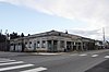
|
Two blocks long, one-half block-deep on either side of Sussex Street; approximately three acres in size. | June 25, 2004 | Sussex Street is the main thoroughfare of the community and is also part of State Route 507. | |
| Tenino Depot | 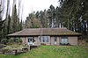
|
Tenino City Park | December 27, 1974 | The Tenino Depot, now a museum, was moved from its original site to the Tenino City Park near the Tenino Stone Company Quarry. At the time the Depot was moved, the area of relocation was examined to ensure that no archaeological remains significant to the operation of the quarry would be destroyed or altered. | |

|
Originally located near the Hercules Sandstone Company Quarry west of Tenino, In 1922, each stone of the building was numbered, moved separately, and reassembled at it current site at the corner of Sussex and Hodgen. It is currently Tenino's City Hall. | ||||
| Tenino Stone Company Quarry | 2712 Huston Street | 1891 | July 28, 1983 | Located in the Tenino City Park, the quarry is now the Memorial Swimming Pool. | |
| 3212 SE Skookumchuck Road now at 399 Park Avenue West | 1934 | May 10, 1990 | Now located in the Tenino City Park, the school was moved from it original location in unincorporated Thurston County to the Tenino City Park next to the Tenino Depot in 2002. | ||
| 6710 Skookumchuck Road | 1860 | ||||
| (Colvin House) | 16828 Old Highway 99 | 1877 | June 23, 1988 | ||
| 4220 SE Old Military Road | 1891 | ||||
| 2400 SE 180th Avenue | 1902 | ||||
| Morgan Davies Barn | S Skookumchuck Road of the junction with Johnson Creek | 1910 | |||
| Engstrom House/Weber House | 3741 SW 143rd Ave | 1910 | |||
| Violet Prairie Grange | 17104 SE Violet Prairie Road | 1935 | |||
| Ada's Resort | 4005 SE 120th Avenue | 1939 | |||
| Linklater Ranch | 13911 Military Road Southeast | ||||
| 4122 SE 119th Avenue | 1915 | Located on | |||
| Offut Lake Resort | 4005 SE 120th Avenue | 1939 |
See also[]
References[]
- ^ "2019 U.S. Gazetteer Files". United States Census Bureau. Retrieved August 7, 2020.
- ^ Jump up to: a b "Annual Estimates of the Resident Population for Incorporated Places in Washington: April 1, 2010 to July 1, 2019". United States Census Bureau. May 2020. Retrieved May 27, 2020.
- ^ Jump up to: a b "U.S. Census website". United States Census Bureau. Retrieved December 19, 2012.
- ^ "US Board on Geographic Names". United States Geological Survey. October 25, 2007. Retrieved January 31, 2008.
- ^ "2010 Census Redistricting Data (Public Law 94-171) Summary File". American FactFinder. United States Census Bureau. Retrieved September 10, 2012.[dead link]
- ^ Guy Ramsey, Postmarked Washington: Thurston County Thurston Co Historic Commission, n.d. 44.
- ^ "Archives Treasure #2: Tenino wooden money". Washington Secretary of State. September 16, 2015. Retrieved June 20, 2020.
- ^ Arthur Dwelley, "Brief History of Tenino" Accessed online at "Archived copy". Archived from the original on January 23, 2010. Retrieved January 21, 2010.CS1 maint: archived copy as title (link) January 20, 2010.
- ^ Greuener, Posey (May 7, 2020). "Washington town plans to use wooden money to boost its economy amid the pandemic". KNKX. Retrieved June 14, 2020.
- ^ Thompson, Franque (May 5, 2020). "Tenino plans to recreate famed Depression-era wooden currency during COVID-19 pandemic". Q13 Fox News. Retrieved June 14, 2020.
- ^ Johnson, Gene (June 17, 2020). "A Washington City Turns To Wooden Money To Get Through The Pandemic". Oregon Public Broadcasting. Associated Press. Retrieved June 20, 2020.
- ^ Guy Reed Ramsey, Postmarked Washington: Thurston County. Thurston Co Historic Commission, 1988, 53.
- ^ Jump up to: a b Edwards, Richard (2019). The Naming of Tenino (PDF). Tenino, WA: Arkeep Press.
- ^ "Washington Standard". November 16, 1872.
- ^ "The Territories" Sacramento Daily Union, May 28, 1873.
- ^ "US Gazetteer files: 2010, 2000, and 1990". United States Census Bureau. 2011-02-12. Retrieved 2011-04-23.
- ^ "US Gazetteer files 2010". United States Census Bureau. Archived from the original on January 12, 2012. Retrieved 2012-12-19.
- ^ United States Census Bureau. "Census of Population and Housing". Retrieved October 11, 2013.
- ^ "Population Estimates". United States Census Bureau. Retrieved June 15, 2019.
- ^ (2005) "Archaeological and historic resources," Thurston County Comprehensive Plan. Retrieved October 18, 2010.
- ^ "Thurston County Historical Register", Thurston County, Washington. Retrieved October 18, 2010.
External links[]
| Wikimedia Commons has media related to Tenino, Washington. |
| show Municipalities and communities of Thurston County, Washington, United States |
|---|

| show Authority control |
|---|
- Tenino, Washington
- Cities in Thurston County, Washington
- Cities in Washington (state)