Toledo Island
 Location of Rugged Island in the South Shetland Islands | |
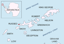
 Toledo Island Location on Antarctic Peninsula | |
| Geography | |
|---|---|
| Location | Antarctica |
| Coordinates | 62°37′29″S 61°18′04″W / 62.62472°S 61.30111°W |
| Archipelago | South Shetland Islands |
| Administration | |
Antarctica | |
| Administered under the Antarctic Treaty System | |
| Demographics | |
| Population | uninhabited |


Toledo Island (Bulgarian: остров Толедо, romanized: ostrov Toledo, IPA: [ˈɔstrof toˈlɛdo]) is the southern of two rocky islands in Smyadovo Cove on the west coast of Rugged Island in the South Shetland Islands. The feature is 320 m (1,050 ft) long in east–west direction and 110 m (360 ft) wide. It is separated from Rugged Island to the southeast and Prosechen Island to the north by 40 and 60 m (130 and 200 ft) wide passages respectively. The area was visited by early 19th century sealers.
The island is named after Joaquín de Toledo y Parra (1780–1819), Captain of the Spanish warship San Telmo that sank with 644 men on board off the north coast of Livingston Island in September 1819.
Location[]
Toledo Island is located at 62°37′29″S 61°18′04″W / 62.62472°S 61.30111°W, which is 1.23 km (0.76 mi) south of Cape Sheffield and 300 m (980 ft) north by west of Ugain Point. Spanish mapping in 1992 and Bulgarian mapping in 2009.
Maps[]
- Península Byers, Isla Livingston. Mapa topográfico a escala 1:25000. Madrid: Servicio Geográfico del Ejército, 1992.
- L.L. Ivanov. Antarctica: Livingston Island and Greenwich, Robert, Snow and Smith Islands. Scale 1:120000 topographic map. Troyan: Manfred Wörner Foundation, 2010. ISBN 978-954-92032-9-5 (First edition 2009. ISBN 978-954-92032-6-4)
- Antarctic Digital Database (ADD). Scale 1:250000 topographic map of Antarctica. Scientific Committee on Antarctic Research (SCAR). Since 1993, regularly upgraded and updated.
- L.L. Ivanov. Antarctica: Livingston Island and Smith Island. Scale 1:100000 topographic map. Manfred Wörner Foundation, 2017. ISBN 978-619-90008-3-0
References[]
- Bulgarian Antarctic Gazetteer. Antarctic Place-names Commission. (details in Bulgarian, basic data in English)
- Toledo Island. SCAR Composite Antarctic Gazetteer.
External links[]
- Toledo Island. Copernix satellite image
This article includes information from the Antarctic Place-names Commission of Bulgaria which is used with permission.
Antarctica | ||
|---|---|---|
| General |
|  |
| Regions |
| |
| Waterways |
| |
| Famous explorers |
| |
This Livingston Island location article is a stub. You can help Wikipedia by . |
- Islands of the South Shetland Islands
- Bulgaria and the Antarctic
- Livingston Island geography stubs