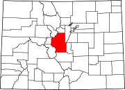
Trump, Colorado
Trump, Colorado | |
|---|---|
 Trump, Colorado | |
| Coordinates: 38°50′57″N 105°47′18″W / 38.84917°N 105.78833°WCoordinates: 38°50′57″N 105°47′18″W / 38.84917°N 105.78833°W | |
| Country | United States |
| State | State of Colorado |
| County | Park County |
| Elevation | 9,436 ft (2,876 m) |
| Time zone | UTC-7 (MST) |
| • Summer (DST) | UTC-6 (MDT) |
| GNIS feature ID | 191366[1] |
Trump is a ghost town in Park County, Colorado, United States.[1]
History[]
Trump was an agricultural and ranching settlement which prospered for a short time during the 1920s and early 1930s.[2][3]
Trump had a store, and a post office which served neighboring ranches. Trump also hosted rodeo competitions between local ranch hands.[2][3]
The population of Trump had declined to three people by 1936.[3]
In 1937, a unique sandstone was identified in the vicinity by J. H. Johnson, and was named "Trump conglomerate" after the nearby settlement.[4][5]
References[]
- ^ a b U.S. Geological Survey Geographic Names Information System: Trump
- ^ a b Park County Local History Archives (2015). Park County. Arcadia. pp. 69, 120. ISBN 9781467132459.
- ^ a b c McConnell Simmons, Virginia (2011). Bayou Salado. University Press of Colorado. ISBN 9781457109447.
- ^ Keroher, Grace C. (1966). Lexicon of Geologic Names of the United States for 1936-1960, Part 3. U.S. Government Printing Office. p. 3966.
- ^ Barkmann, Peter E.; Sterne, Edward J.; Dechesne, Marieke; Houck, Karen J. (2016). Keller, Stephen M.; Morgan, Matthew L. (eds.). South Park, Colorado: The Interplay Of Tectonics And Sedimentation Creates One Of Colorado's Crown Jewels. Unfolding The Geology Of The West. Geological Society of America. p. 162. ISBN 9780813700441.
Categories:
- Ghost towns in Colorado
- Former populated places in Park County, Colorado
- Colorado stubs


