Alma, Colorado
Alma, Colorado | |
|---|---|
Statutory Town[1] | |
| Town of Alma[1] | |
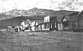
 Main Street | |
 Location of the Town of Alma in Park County, Colorado. | |
 Alma Location of the Town of Alma in the United States. | |
| Coordinates: 39°17′09″N 106°03′59″W / 39.285942°N 106.066319°WCoordinates: 39°17′09″N 106°03′59″W / 39.285942°N 106.066319°W[5] | |
| Country | United States |
| State | Colorado |
| County[1] | Park County[2] |
| Incorporated | 1873-12-02[3] |
| Named for | Alma James[7] |
| Government | |
| • Type | Statutory Town[1] |
| Area | |
| • Statutory Town[1] | 0.436 sq mi (1.129 km2) |
| • Land | 0.434 sq mi (1.123 km2) |
| • Water | 0.002 sq mi (0.006 km2) |
| Elevation | 10,361 ft (3,158 m) |
| Population | |
| • Statutory Town[1] | 296 |
| • Density | 683/sq mi (264/km2) |
| • Metro | 2,963,821 (19th) |
| • CSA | 3,623,560 (17th) |
| • Front Range | 5,055,344 |
| Time zone | UTC−07:00 (MST) |
| • Summer (DST) | UTC−06:00 (MDT) |
| ZIP code | 80420[6] |
| Area code(s) | 719 |
| FIPS code | 08-01530 |
| GNIS feature ID | 0180003 |
| Highways | |
| Website | townofalma |

The Town of Alma is a Statutory Town located in Park County, Colorado, United States.[1] The town population was 296 at the 2020 United States Census.[4] Alma is a part of the Denver-Aurora-Lakewood, CO Metropolitan Statistical Area and the Front Range Urban Corridor.
At an elevation of approximately 10,578 feet (3,224 m), it is the highest incorporated municipality in the United States when considering only areas with permanent residents.[2] Its United States Post Office is located at the highest elevation of any in the country.[8] Alma, which is considered a town and not a city, does not take the title of "highest incorporated city" from Leadville, Colorado. Using administrative boundaries as a measure, not settled areas, in 2006 Winter Park, Colorado became the highest incorporated town due to its annexation of a ski area.[9] Beyond the official limits of Alma is a residential area which extends to 11,680 feet (3,560 m) above sea level on Mountain View Drive. However, this area uses Fairplay, Colorado addresses, despite being slightly closer to Alma.
The town was named by a merchant named Mr. James, after his wife.[7] Another tradition states the town was named for the daughter of a resident.[10]
Geography[]
Alma is located at 39°17′03″N 106°03′48″W / 39.284116°N 106.063322°W,[11] along State Highway 9.
At the 2020 United States Census, the town had a total area of 279 acres (1.129 km2) including 1.5 acres (0.006 km2) of water.[4]
Climate[]
Alma has a subarctic climate (Dfc), or what could be called a subalpine climate due to its elevation, with only two months above the 50° isotherm. Alma is the coldest inhabited town in the Lower 48, having a lower yearly mean than other towns known for their extreme cold temperatures, such as Embarrass, Minnesota. Summers are pleasant, with mild days and chilly nights and have no real growing season due to frosts and occasional summer snow. The wettest months are July and August due to thunderstorm activity. Spring and Autumn are both short, but pleasant overall with cool days and cold nights below freezing. Winters are very cold and snowy, lasting from the end of October to well into April some years. Winter highs are almost always below freezing and lows remaining around zero for 1/3 of the year. Alma's snowpack is usually established during October or very early November and lasts into June most years due to heavy snowfall and low night temperatures allowing the snowpack to keep re-freezing overnight. Alma's high elevation and location helps to limit both extreme minima and maxima. Interestingly, April averages the most snowfall out of any month of the year.[12][13][14]
| hideClimate data for Alma | |||||||||||||
|---|---|---|---|---|---|---|---|---|---|---|---|---|---|
| Month | Jan | Feb | Mar | Apr | May | Jun | Jul | Aug | Sep | Oct | Nov | Dec | Year |
| Record high °F (°C) | 57 (14) |
57 (14) |
64 (18) |
66 (19) |
80 (27) |
86 (30) |
84 (29) |
83 (28) |
82 (28) |
72 (22) |
66 (19) |
56 (13) |
86 (30) |
| Average high °F (°C) | 27.9 (−2.3) |
30.4 (−0.9) |
33.6 (0.9) |
41.2 (5.1) |
51.3 (10.7) |
62.2 (16.8) |
68.2 (20.1) |
65.7 (18.7) |
59 (15) |
49.1 (9.5) |
35.8 (2.1) |
28.6 (−1.9) |
46.1 (7.8) |
| Daily mean °F (°C) | 14.2 (−9.9) |
15.8 (−9.0) |
19.9 (−6.7) |
28.2 (−2.1) |
38.3 (3.5) |
47.8 (8.8) |
53.6 (12.0) |
51.6 (10.9) |
45 (7) |
35.6 (2.0) |
23.2 (−4.9) |
15.6 (−9.1) |
32.4 (0.2) |
| Average low °F (°C) | 0.5 (−17.5) |
1.4 (−17.0) |
6.3 (−14.3) |
15.4 (−9.2) |
25.5 (−3.6) |
33.4 (0.8) |
39.2 (4.0) |
37.8 (3.2) |
30.9 (−0.6) |
22.3 (−5.4) |
10.8 (−11.8) |
2.8 (−16.2) |
18.9 (−7.3) |
| Record low °F (°C) | −35 (−37) |
−38 (−39) |
−30 (−34) |
−17 (−27) |
3 (−16) |
18 (−8) |
21 (−6) |
23 (−5) |
8 (−13) |
−8 (−22) |
−24 (−31) |
−31 (−35) |
−38 (−39) |
| Average precipitation inches (mm) | 1.46 (37) |
1.30 (33) |
1.73 (44) |
1.77 (45) |
1.65 (42) |
1.46 (37) |
2.40 (61) |
2.40 (61) |
1.58 (40) |
1.26 (32) |
1.42 (36) |
1.58 (40) |
20.01 (508) |
| Average snowfall inches (cm) | 17 (43) |
19.8 (50) |
22 (56) |
23.1 (59) |
9.2 (23) |
1.3 (3.3) |
0.1 (0.25) |
0 (0) |
2 (5.1) |
10.9 (28) |
21.5 (55) |
19 (48) |
145.9 (370.65) |
| Average snowy days | 9.5 | 8.7 | 10.4 | 9.2 | 4 | 0.6 | 0 | 0 | 0.9 | 3.9 | 8.4 | 8.9 | 64.5 |
| [citation needed] | |||||||||||||
Demographics[]
| Historical population | |||
|---|---|---|---|
| Census | Pop. | %± | |
| 1880 | 446 | — | |
| 1890 | 367 | −17.7% | |
| 1900 | 297 | −19.1% | |
| 1910 | 301 | 1.3% | |
| 1920 | 127 | −57.8% | |
| 1930 | 110 | −13.4% | |
| 1940 | 469 | 326.4% | |
| 1950 | 149 | −68.2% | |
| 1960 | 107 | −28.2% | |
| 1970 | 73 | −31.8% | |
| 1980 | 132 | 80.8% | |
| 1990 | 148 | 12.1% | |
| 2000 | 179 | 20.9% | |
| 2010 | 270 | 50.8% | |
| 2020 | 296 | 9.6% | |
| U.S. Decennial Census | |||
As of the census[15] of 2000, there were 179 people, 94 households, and 40 families residing in the town. The population density was 523.6 people per square mile (203.3/km2). There were 147 housing units at an average density of 430.0 per square mile (166.9/km2). The racial makeup of the town was 92.74% White, 2.23% Native American, 0.56% Asian, 3.35% from other races, and 1.12% from two or more races. Hispanics or Latinos of any race were 3.35% of the population.
There were 94 households, of which 18.1% had children under the age of 18 living with them, 37.2% were married couples living together, 2.1% had a female householder with no husband present, and 57.4% were non-families. 39.4% of all households were made up of individuals, and 1.1% had someone living alone who was 65 years of age or older. The average household size was 1.90 and the average family size was 2.63.
The age distribution was 12.8% under the age of 18, 5.6% from 18 to 24, 53.1% from 25 to 44, 24.0% from 45 to 64, and 4.5% who were 65 years of age or older. The median age was 37 years. For every 100 females, there were 132.5 males. For every 100 females age 18 and over, there were 140.0 males.
The median income for a household in the town was $41,563, and the median income for a family was $59,688. Males had a median income of $28,750 versus $26,563 for females. The per capita income for the town was $25,165. None of the families and 4.3% of the population were living below the poverty line.
Mines[]
Approximately two miles from Alma are the remains of the defunct Orphan Boy mine (founded 1861), which produced gold, silver, lead, and zinc over a number of decades.[16]
The historic Sweet Home Mine near Alma, formerly a silver mine, now produces spectacular rhodochrosite mineral specimens.
Gallery[]
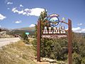
Alma Town Sign
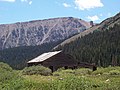
London mine building, near Alma
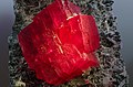
Rhodochrosite specimen from the Sweet Home mine, near Alma
Alma, c. 1870s


See also[]
- Colorado
- Bibliography of Colorado
- Index of Colorado-related articles
- Outline of Colorado
- List of places in Colorado
- Colorado metropolitan areas
- Front Range Urban Corridor
- North Central Colorado Urban Area
- Denver-Aurora, CO Combined Statistical Area
- Denver-Aurora-Lakewood, CO Metropolitan Statistical Area
- List of highest towns by country
References[]
- ^ Jump up to: a b c d e "Active Colorado Municipalities". State of Colorado, Department of Local Affairs. Archived from the original on 2009-12-12. Retrieved 2007-09-01.
- ^ Jump up to: a b c "US Board on Geographic Names". United States Geological Survey. 2007-10-25. Retrieved 2008-01-31.
- ^ "Colorado Municipal Incorporations". State of Colorado, Department of Personnel & Administration, Colorado State Archives. 2004-12-01. Archived from the original on 27 September 2007. Retrieved 2007-08-18.
- ^ Jump up to: a b c d "Decennial Census P.L. 94-171 Redistricting Data". United States Census Bureau, United States Department of Commerce. August 12, 2021. Retrieved September 2, 2021.
- ^ "2014 U.S. Gazetteer Files: Places". United States Census Bureau. July 1, 2014. Retrieved January 5, 2015.
- ^ "ZIP Code Lookup". United States Postal Service. August 21, 2007. Retrieved June 26, 2017.
- ^ Jump up to: a b Gannett, Henry (1905). The Origin of Certain Place Names in the United States. U.S. Government Printing Office. pp. 22.
- ^ United States Postal Service. "Fun Facts - Postal Facts".
- ^ "Geographical Information". Town of Winter Park. Archived from the original on 2013-10-04. Retrieved 2013-10-01.
- ^ Dawson, John Frank (1954). Place names in Colorado: why 700 communities were so named, 150 of Spanish or Indian origin. Denver, CO: The J. Frank Dawson Publishing Co. p. 6.
- ^ "US Gazetteer files: 2010, 2000, and 1990". United States Census Bureau. 2011-02-12. Retrieved 2011-04-23.
- ^ "Alma climate: Average Temperature, weather by month, Alma weather averages - Climate-Data.org". en.climate-data.org. Retrieved 2020-07-28.
- ^ "Alma Climate". Retrieved July 28, 2020.
- ^ "Alma, CO Monthly Weather Forecast - weather.com". The Weather Channel. Retrieved 2020-07-28.
- ^ "U.S. Census website". United States Census Bureau. Retrieved 2008-01-31.
- ^ Laura King Van Dusen, "Early Days at the Orphan Boy: Fire in December 2011 Not Only Fire at Mine; Gold Production Worth $486 Million in 2013 Dollars", Historic Tales from Park County: Parked in the Past (Charleston, South Carolina: The History Press, 2013), ISBN 978-1-62619-161-7, pp. 37-43.
External links[]
| Wikimedia Commons has media related to Alma, Colorado |
- Town of Alma website
- Alma Foundation website
- CDOT map of the Town of Alma
- SteveGarufi.com - Alma, CO
- Ghost Town photos of Alma featured by RockyMountainProfiles.com
| show Municipalities and communities of Park County, Colorado, United States |
|---|


| show Authority control |
|---|
- Towns in Park County, Colorado
- Towns in Colorado