Typhoon Mitag (2019)
This article may need to be rewritten to comply with Wikipedia's quality standards. (May 2020) |
| Typhoon (JMA scale) | |
|---|---|
| Category 2 typhoon (SSHWS) | |
 Typhoon Mitag near peak intensity brushing Taiwan on September 30 | |
| Formed | September 27, 2019 |
| Dissipated | October 5, 2019 |
| (Extratropical after October 3) | |
| Highest winds | 10-minute sustained: 140 km/h (85 mph) 1-minute sustained: 165 km/h (105 mph) |
| Lowest pressure | 965 hPa (mbar); 28.5 inHg |
| Fatalities | 17 |
| Damage | > $816 million (2019 USD) |
| Areas affected | Philippines, Ryukyu Islands, Taiwan, East China (particularly Zhoushan), South Korea |
| Part of the 2019 Pacific typhoon season | |
Typhoon Mitag, known in the Philippines as Typhoon Onyok, was a moderately strong tropical cyclone that severely affected Taiwan, East China and South Korea in early October 2019. The 23rd depression and the 8th typhoon of the 2019 Pacific typhoon season, Mitag developed from a low pressure system near the Micronesia Islands on September 24. Tracking generally northwestward, the system gradually organised and the Japanese Meteorological Agency issued its first advisory on Tropical Depression 19W on September 27. It continued northeastward, gradually organizing and becoming less broad. It was then upgraded to Tropical Storm Mitag on September 28. The storm quickly intensified, becoming a Category 1 typhoon just a day later. It further intensified into a Category 2 typhoon, passing very close to Taiwan. It weakened thereafter, making landfall near Zhoushan in East China on October 1 before weakening back to a poorly organized tropical storm. It later made landfall in South Korea on October 2 before becoming extratropical in the Japan Sea on October 3.
Meteorological history[]

Tropical storm (39–73 mph, 63–118 km/h)
Category 1 (74–95 mph, 119–153 km/h)
Category 2 (96–110 mph, 154–177 km/h)
Category 3 (111–129 mph, 178–208 km/h)
Category 4 (130–156 mph, 209–251 km/h)
Category 5 (≥157 mph, ≥252 km/h)
Unknown
Mitag developed from a low pressure system near the Micronesia Islands on September 24. Tracking generally northwestward, the system gradually organised and the Japanese Meteorological Agency issued its first advisory on Tropical Depression 19W on September 27. Traipsing toward the Philippines and eventually entering the Philippine Area of Responsibility the next day[1] with the Philippine Atmospherical, Geological and Astronomical Services Administration routinely named it Onyok. The JMA followed suit after the system intensified to become a tropical storm, naming it Mitag on September 28.[2] The JTWC's projected track path lead Mitag toward the Ryukyu Islands, all while strengthening. Mitag, while gaining latitude, strengthened quickly on September 29 and within just hours became a severe tropical storm,[3] and shortly after, a category 1 typhoon later on that same day.[4]
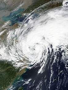
Developing a visible circulation and with thick bands of strong convection, it swiftly became a category 2 typhoon on the evening of September 30, with a small, clouded eye developing as it passed just east of Taiwan.[5][6] Due to a sudden increase in wind shear and decrease in sea surface temperatures, Mitag began to quickly degrade after becoming a category 2 typhoon, and weakened to a category 1 typhoon before making its first mainland landfall on Zhoushan, exiting the Philippine Area of Responsibility.[7][8] The land interaction disrupted Mitag by quite some margin, and it weakened to a tropical storm relatively quickly during landfall. It quickly moved northeast towards South Korea as it began to enter its extratropical transition on the evening of October 1.[9] Mitag made its second landfall on South Korea on October 2 whilst surprisingly holding onto tropical storm strength and remaining a poorly organized tropical cyclone.[10] Shortly after land interaction with South Korea, its low-level circulation center was continually exposed by westerly wind shear and its cloud tops became displaced, leading to it weakening below tropical depression status on October 3 and becoming extratropical the next day.[11]
Preparations and Impact[]
The Philippines[]
As Mitag was initially forecast to come near the Philippines, a Signal 1 warning was raised for a portion of Luzon and the Batanes and the Babuyan Islands as the storm passed just northeast of the country as a category 1 typhoon. The PAGASA also noted that in its path it would bring showers and isolated thunderstorms over the Cagayan valley in its passing, and rough sea conditions as well.[12] As forecast, the storm's outer bands produced heavy rainfall, rough sea conditions, and gusty winds in Northern Luzon, but no damage was reported.[13]
Taiwan[]
As Mitag approached Taiwan from the southeast, an Orange Tropical Cyclone Alert was raised for Taiwan on September 29, the second-highest possible.[14] On the same day, the Taiwanese government ordered a total closure of all financial markets and schools in the country as Mitag advanced towards Taiwan, while airlines in the country also cancelled dozens of flights amid warnings of floods and high winds issued by the country's meteorological agency.[15]
South Korea[]
This section is empty. You can help by . (February 2020) |
See also[]
References[]
- ^ "Severe Weather Bulletin no 1 for Tropical Depression Onyok" (PDF). Republic of the Philippines Natural Disaster Risk Reduction and Management Center. September 28, 2019. Retrieved January 18, 2020.
- ^ "Severe Weather Bulletin no. 3 for Tropical Storm Onyok (Mitag)" (PDF). Republic of the Philippines Natural Disaster Risk Reduction and Management Center. September 29, 2019. Retrieved January 18, 2020.
- ^ "Severe Weather Bulletin no. 5 for Severe Tropical Storm Onyok (Mitag)" (PDF). Republic of the Philippines Natural Disaster Risk Reduction and Management Center. September 29, 2019. Retrieved January 18, 2020.
- ^ "Severe Weather Bulletin no. 8 for Typhoon Onyok (Mitag)" (PDF). Republic of the Philippines Natural Disaster Risk Reduction and Management Center. September 29, 2019. Retrieved January 18, 2020.
- ^ "Severe Weather Bulletin no. 9 for Typhoon Onyok (Mitag)" (PDF). Republic of the Philippines Natural Disaster Risk Reduction and Management Center. September 30, 2019. Retrieved January 18, 2020.
- ^ "NASA finds Typhoon Mitag's eye east of Taiwan". Phys.org. September 30, 2019. Retrieved January 18, 2020.
- ^ "Severe Weather Bulletin no. 13 on Typhoon Onyok (Mitag) (FINAL)" (PDF). Republic of the Philippines Natural Disaster Risk Reduction and Management Center. October 1, 2019. Retrieved January 18, 2020.
- ^ "Typhoon Mitag Lashes Eastern China, Heads to South Korea". Insurance Journal. October 1, 2019. Retrieved January 18, 2020.
- ^ "Oct. 01, 2019 – NASA Satellite Shows Typhoon Mitag's Large Reach Over East China Sea". NASA Blogs. October 1, 2019. Retrieved January 18, 2020.
- ^ "Oct. 02, 2019 – NASA Finds Mitag's Areas of Heavy Rainfall over Korean Peninsula". NASA Blogs. October 2, 2019. Retrieved January 18, 2020.
- ^ "Oct. 03, 2019 – NASA Finds a Transitioning Cyclone Mitag Filling the Sea of Japan". NASA Blogs. October 3, 2019. Retrieved January 18, 2020.
- ^ "Signal number 1 still up as 'Onyok' intensifies into a typhoon". CNN Philippines. September 29, 2019. Retrieved January 18, 2020.
- ^ "Onyok continues to bring rains in Northern Luzon". Phil Star. October 1, 2019. Retrieved January 19, 2020.
- ^ "Overall Orange alert Tropical Cyclone for MITAG-19". Global Disaster Alert and Coordination System (GDACS). September 30, 2019. Retrieved January 19, 2020.
- ^ "Taiwan orders markets, schools closed as strong typhoon approaches". CNBC. September 30, 2019. Retrieved January 19, 2020.
Tropical cyclones of the 2019 Pacific typhoon season | ||||||||||||||||||||||||||||||||||||||||||||||||||||||||||||||||||||||||||||||||||||||||||||||||||||||||||
|---|---|---|---|---|---|---|---|---|---|---|---|---|---|---|---|---|---|---|---|---|---|---|---|---|---|---|---|---|---|---|---|---|---|---|---|---|---|---|---|---|---|---|---|---|---|---|---|---|---|---|---|---|---|---|---|---|---|---|---|---|---|---|---|---|---|---|---|---|---|---|---|---|---|---|---|---|---|---|---|---|---|---|---|---|---|---|---|---|---|---|---|---|---|---|---|---|---|---|---|---|---|---|---|---|---|---|
 |
| |||||||||||||||||||||||||||||||||||||||||||||||||||||||||||||||||||||||||||||||||||||||||||||||||||||||||
| ||||||||||||||||||||||||||||||||||||||||||||||||||||||||||||||||||||||||||||||||||||||||||||||||||||||||||
- 2019 Pacific typhoon season
- Typhoons in China