Ulu (island)
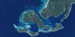 Ulu island, center left, in the Duke of York Islands group. NASA Landsat 7 image, 2000. | |
 Ulu | |
| Geography | |
|---|---|
| Location | Melanesia |
| Coordinates | 4°13′0″S 152°25′0″E / 4.21667°S 152.41667°ECoordinates: 4°13′0″S 152°25′0″E / 4.21667°S 152.41667°E |
| Archipelago | Solomon Islands |
| Adjacent bodies of water | Solomon Sea |
| Highest elevation | 1 m (3 ft) |
| Administration | |
Papua New Guinea | |
| Province | East New Britain Province |
| Capital city | Port Moresby |
| Largest settlement | Port Moresby |
| Prime Minister | Peter O'Neill |

Ulu Island is the second largest island in the Duke of York island group. It is situated between Duke of York Island and Kabakon and Kerawara islands.[1]
The island is on Papua New Guinea Time (PGT).[2] This works out as UTC/GMT +10:00 hours. They do not observe Daylight saving time.
The word Ulu means breadfruit.[3]
Other Names[]
Ulu is also known as Mauke Island or Pig Island
References[]
- ^ "Ulu Island". Mapcarta. Retrieved 18 August 2015.
- ^ "Current Time In Ulu Island, Papua New Guinea - WorldTime.io". worldtime.io. Retrieved 18 August 2015.
- ^ "Ulu Island, East New Britain Province, Papua New Guinea - Satellite View and Map". satelliteview.co. Retrieved 18 August 2015.
This East New Britain Province geography article is a stub. You can help Wikipedia by . |
Categories:
- Islands of Papua New Guinea
- East New Britain Province
- Islands Region geography stubs