Wichita Falls metropolitan area
This article needs additional citations for verification. (May 2021) |
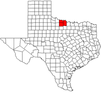
The Wichita Falls metropolitan statistical area is a metropolitan area in North Texas that covers three counties – Archer, Clay, and Wichita. As of the 2010 census, the MSA had a population of 151,306 (though a July 1, 2011 estimate placed the population at 150,261).[1]
Counties[]
Communities[]
Places with more than 100,000 people[]
- Wichita Falls (Principal City)
Places with 1,000 to 15,000 people[]
Places with 500 to 1,000 people[]
Places with less than 500 people[]
Unincorporated places[]
- Bluegrove
- Buffalo Springs
- Dundee
- Halsell
- Haynesville
- Huff
- Hurnville
- Joy
- Kamay
- Mankins
- Shannon
- Stanfield
- Thornberry
- Valley View
- Vashti
Demographics[]
As of the census[2] of 2000, there were 151,524 people, 56,109 households, and 38,587 families residing within the MSA. The racial makeup of the MSA was 80.95% White, 8.92% African American, 0.89% Native American, 1.61% Asian, 0.08% Pacific Islander, 5.05% from other races, and 2.51% from two or more races. Hispanic or Latino of any race were 11.17% of the population.
The median income for a household in the MSA was $36,011 and the median income for a family was $42,812. Males had a median income of $29,662 versus $21,660 for females. The per capita income for the MSA was $17,542.
See also[]
- List of cities in Texas
- List of museums in North Texas
- Texas census statistical areas
- List of Texas metropolitan areas
References[]
- ^ "Metropolitan and Micropolitan Statistical Areas". 2011 Population Estimates. United States Census Bureau, Population Division. July 1, 2011. Retrieved November 26, 2012.
- ^ "U.S. Census website". United States Census Bureau. Retrieved 2008-01-31.

- Wichita Falls metropolitan area
- Geography of Archer County, Texas
- Geography of Clay County, Texas
- Geography of Wichita County, Texas