Archer County, Texas
Archer County | |
|---|---|
U.S. county | |
 The Archer County Courthouse in Archer City: The Romanesque style structure was added to the National Register of Historic Places in 1977. | |
 Location within the U.S. state of Texas | |
 Texas's location within the U.S. | |
| Coordinates: 33°37′N 98°41′W / 33.61°N 98.69°W | |
| Country | |
| State | |
| Founded | 1880 |
| Named for | Branch Tanner Archer |
| Seat | Archer City |
| Largest city | Archer City |
| Area | |
| • Total | 925 sq mi (2,400 km2) |
| • Land | 903 sq mi (2,340 km2) |
| • Water | 22 sq mi (60 km2) 2.4%% |
| Population (2010) | |
| • Total | 9,054 |
| • Density | 10/sq mi (4/km2) |
| Time zone | UTC−6 (Central) |
| • Summer (DST) | UTC−5 (CDT) |
| Congressional district | 13th |
| Website | www |


Archer County is a county located in the U.S. state of Texas. As of the 2010 census, its population was 9,054.[1] Its county seat is Archer City.[2]
Archer County is part of the Wichita Falls metropolitan statistical area.
Archer County is represented in the Texas House of Representatives by Republican James Frank, a businessman from Wichita Falls.
History[]
Along with the rest of Texas, Archer County became:
· Part of an independent Mexico on September 27, 1821
· Part of the slave-holding Republic of Texas on March 2, 1836
· Part of a slave-holding state of the United States of America on December 29, 1845
· Part of the slave-holding Confederate States of America on March 4, 1861
· Part of a state coerced to acknowledge Union authority on June 19, 1865
In 1858, the Texas Legislature established Archer County from portions of Fannin County, Texas, and it organized in 1880.[3] It is named for Branch Tanner Archer, a commissioner for the Republic of Texas.
Geography[]
According to the U.S. Census Bureau, the county has a total area of 925 sq mi (2,400 km2), of which 903 sq mi (2,340 km2) are land and 22 sq mi (57 km2) (2.4%) are covered by water.[4]
Major highways[]
 U.S. Highway 82
 U.S. Highway 277
 U.S. Highway 281
 State Highway 25
 State Highway 79
 State Highway 114
Adjacent counties[]
- Wichita County (north)
- Clay County (east)
- Jack County (southeast)
- Young County (south)
- Baylor County (west)
- Wilbarger County (northwest)
Geology[]
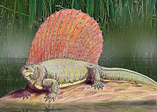
Archer County is part of the Texas Red Beds, which are strata of red-colored sedimentary rock from the Early Permian. The fossils of Permian-period vertebrates in the Texas Red Beds were first discovered by Edward Drinker Cope in 1877.[5][6] Subsequent research has revealed rare fossils of Permian period amphibians such as Trimerorhachis,[7] and rich deposits of other Permian tetrapods such as Dimetrodon and Diadectes.[8] One of the most prominent fossil sites in the red beds is the Geraldine Bonebed, which is located in Archer County.[9]
Demographics[]
| Historical population | |||
|---|---|---|---|
| Census | Pop. | %± | |
| 1880 | 596 | — | |
| 1890 | 2,101 | 252.5% | |
| 1900 | 2,508 | 19.4% | |
| 1910 | 6,525 | 160.2% | |
| 1920 | 5,254 | −19.5% | |
| 1930 | 9,684 | 84.3% | |
| 1940 | 7,599 | −21.5% | |
| 1950 | 6,816 | −10.3% | |
| 1960 | 6,110 | −10.4% | |
| 1970 | 5,759 | −5.7% | |
| 1980 | 7,266 | 26.2% | |
| 1990 | 7,973 | 9.7% | |
| 2000 | 8,854 | 11.0% | |
| 2010 | 9,054 | 2.3% | |
| 2019 (est.) | 8,553 | [10] | −5.5% |
| U.S. Decennial Census[11] 1850–2010[12] 2010–2014[1] | |||
As of the census[13] of 2000, 8,854 people, 3,345 households, and 2,515 families resided in the county. The population density was 10 people/sq mi (4/km2). The 3,871 housing units averaged 4/sq mi (2/km2). The racial makeup of the county was 95.54% White, 0.08% African American, 0.62% Native American, 0.12% Asian, 0.03% Pacific Islander, 2.28% from other races, and 1.32% from two or more races. About 4.87% of the population was Hispanic or Latino of any race.
Of the 3,345 households, 37.20% had children under 18 living with them, 65.00% were married couples living together, 7.20% had a female householder with no husband present, and 24.80% were not families. Of all unmarried partner households, 89.8% were heterosexual, 1.9% were same-sex male, and 8.3% were same-sex female. About 21.90% of all households were made up of individuals, and 10.20% had someone living alone who was 65 or older. The average household size was 2.63, and the average family size was 3.08.
In the county, the age distribution was 28.20% under 18, 7.00% from 18 to 24, 27.40% from 25 to 44, 23.50% from 45 to 64, and 13.90% who were 65 or older. The median age was 38 years. For every 100 females, there were 100.20 males. For every 100 females age 18 and over, there were 96.20 males.
The median income for a household in the county was $38,514, and for a family was $45,984. Males had a median income of $31,386 versus $22,119 for females. The per capita income for the county was $19,300. About 6.80% of families and 9.00% of the population were below the poverty line, including 9.90% of those under age 18 and 10.80% of those age 65 or over.
Education[]
These school districts serve Archer County:
- Archer City Independent School District
- Holliday Independent School District
- Iowa Park Consolidated Independent School District (partial)
- Jacksboro Independent School District (partial)
- Olney Independent School District (partial)
- Windthorst Independent School District
Megargel Independent School District once served portions of Archer County, but it closed after the fall of 2006.
Ranching industry[]
The Seymour Division of the sprawling 320,000-deeded-acre (1400 km2) La Escalera Ranch is located north of Seymour, Texas in Baylor County and part of Archer County. The Seymour Division consists of 34,000 acres (12,000 ha>), which was formerly known as the Cross Bar Ranch when it was owned by the Claude Cowan Sr. Trust. The ranch was purchased in January, 2005 by the Gerald Lyda family and La Escalera Limited Partnership and is managed by partner Jo Lyda Granberg and her husband K. G. Granberg of Seymour. La Escalera Ranch extends over much of Pecos County and portions of Reeves, Brewster, Archer, and Baylor Counties. It is known for its herd of Black Angus cattle and its abundant wildlife.
Joseph Sterling Bridwell, a Wichita Falls philanthropist and oilman, also owned a ranch in Archer County.[14]
Dairy industry[]
Archer County is one of the more prominent areas of dairy product production in Texas. The two southeastern Archer County cities of Scotland and Windthorst have 37 functioning dairy farms nearby as of 2019. The dairy industry moved to the area in the early 1900s and has persisted through the years. Though this area has many operating dairies, the number of dairy cattle makes up a fractions of the numbers that are raised in the other dairy pockets of Texas such as Dalhart/Dumas and the Stephenville area. Every dairy farm in the Scotland/Windthorst area is family owned, and this is from where most of the economy of the two cities derives.[citation needed]
Politics[]
Archer County is heavily Republican, and has voted for the presidential candidate of that party in every election since 1980.
Communities[]
Cities[]
- Archer City (county seat)
- Holliday
- Scotland
Towns[]
- Lakeside City
- Megargel
- Windthorst (partly in Clay County)
Unincorporated communities[]
Ghost towns[]
See also[]
- List of museums in North Texas
- National Register of Historic Places listings in Archer County, Texas
- Recorded Texas Historic Landmarks in Archer County
- Lake Wichita
References[]
- ^ Jump up to: a b "State & County QuickFacts". United States Census Bureau. Archived from the original on July 6, 2011. Retrieved December 8, 2013.
- ^ "Find a County". National Association of Counties. Archived from the original on 2011-05-31. Retrieved 2011-06-07.
- ^ "Texas: Individual County Chronologies". Texas Atlas of Historical County Boundaries. The Newberry Library. 2008. Retrieved May 20, 2015.
- ^ "2010 Census Gazetteer Files". United States Census Bureau. August 22, 2012. Retrieved April 18, 2015.
- ^ Cope, E. D. Descriptions of extinct vertebrata from the Permian and Triassic formations of the United States. Proceedings of the American Philosophical Society, 1877. Volume 17:182–195. JSTOR. Accessed on August 28, 2017.
- ^ Case, E.C.The Red Beds between Wichita Falls, Texas, and Las Vegas, New Mexico, in Relation to Their Vertebrate Fauna. The Journal of Geology, vol. 22, no. 3, 1914, pp. 243–259. JSTOR. Accessed on August 28, 2017.
- ^ Henry, Randy. NRCS and Landowner Team Up With Houston Museum after Rare Species Discovery. Natural Resources Conservation Service. Accessed on August 28, 2017.
- ^ Caulfield, Dave. Prehistoric Predators: Fossil Findings in Seymour 'Redefining'. Newschannel 6: October 25, 2015. Accessed on August 28, 2017.
- ^ The Book Of Life: An Illustrated History of the Evolution of Life on Earth. W.W. Norton: 2001, pg. 94. Retrieved August 28, 2017.
- ^ "Population and Housing Unit Estimates". United States Census Bureau. May 24, 2020. Retrieved May 27, 2020.
- ^ "U.S. Decennial Census". United States Census Bureau. Retrieved April 18, 2015.
- ^ "Texas Almanac: Population History of Counties from 1850–2010" (PDF). Texas Almanac. Retrieved April 18, 2015.
- ^ "U.S. Census website". United States Census Bureau. Retrieved 2011-05-14.
- ^ "Jack O. Loftin, "Joseph Sterling Bridwell"". Texas State Historical Association online. 2010-06-12. Retrieved April 30, 2013.
- ^ Leip, David. "Dave Leip's Atlas of U.S. Presidential Elections". uselectionatlas.org. Retrieved 2018-07-19.
External links[]
| Wikimedia Commons has media related to Archer County, Texas. |
- Archer County government
- Archer County, Texas from the Handbook of Texas Online
- Archer County from the Texas Almanac
- Archer County from the TXGenWeb Project
- Historic Archer County materials, hosted by the Portal to Texas History
| show Places adjacent to Archer County, Texas |
|---|
| show Municipalities and communities of Archer County, Texas, United States |
|---|


| show Authority control |
|---|
- Texas counties
- Archer County, Texas
- 1880 establishments in Texas
- Wichita Falls metropolitan area
- Populated places established in 1880