Únehle
Únehle | |
|---|---|
Municipality | |
 | |
 Flag  Coat of arms | |
 Únehle | |
| Coordinates: 49°47′24″N 13°1′13″E / 49.79000°N 13.02028°ECoordinates: 49°47′24″N 13°1′13″E / 49.79000°N 13.02028°E | |
| Country | |
| Region | Plzeň |
| District | Tachov |
| Area | |
| • Total | 6.06 km2 (2.34 sq mi) |
| Elevation | 449 m (1,473 ft) |
| Population (2008) | |
| • Total | 134 |
| • Density | 22/km2 (57/sq mi) |
| Postal code | 349 01 |

Únehle is a village and municipality (obec) in Tachov District in the Plzeň Region of the Czech Republic.
The municipality covers an area of 6.06 square kilometres (2.34 sq mi), and has a population of 134 (as at 3 July 2008).
Únehle lies approximately 30 kilometres (19 mi) east of Tachov, 26 km (16 mi) west of Plzeň, and 106 km (66 mi) west of Prague.
Gallery[]

Bus stop
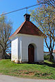
Small chapel
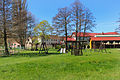
Playground


References[]
| Wikimedia Commons has media related to Únehle. |
| Authority control: National libraries |
|---|
This Plzeň Region location article is a stub. You can help Wikipedia by . |
Categories:
- Villages in Tachov District
- Plzeň Region geography stubs