Záchlumí (Tachov District)
Záchlumí | |
|---|---|
Municipality | |
 | |
 Flag  Coat of arms | |
 Záchlumí | |
| Coordinates: 49°47′51″N 12°57′50″E / 49.79750°N 12.96389°ECoordinates: 49°47′51″N 12°57′50″E / 49.79750°N 12.96389°E | |
| Country | |
| Region | Plzeň |
| District | Tachov |
| Area | |
| • Total | 4.41 km2 (1.70 sq mi) |
| Elevation | 497 m (1,631 ft) |
| Population (2006) | |
| • Total | 408 |
| • Density | 93/km2 (240/sq mi) |
| Postal code | 349 01 |
| Website | http://www.zachlumi.cz |

Záchlumí (German Eisenhuttel) is a village and municipality (obec) in Tachov District in the Plzeň Region of the Czech Republic.
The municipality covers an area of 4.41 square kilometres (1.70 sq mi), and has a population of 408 (as at 3 July 2006).
Záchlumí lies approximately 25 kilometres (16 mi) east of Tachov, 31 km (19 mi) west of Plzeň, and 110 km (68 mi) west of Prague.
Gallery[]
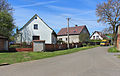
Middle part
Tenement houses
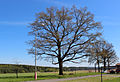
Old oak – protected tree


References[]
| Wikimedia Commons has media related to Záchlumí (Tachov District). |
| Authority control: National libraries |
|---|
This Plzeň Region location article is a stub. You can help Wikipedia by . |
Categories:
- Villages in Tachov District
- Plzeň Region geography stubs