Planá (Tachov District)
Planá
Planá u Mariánských Lázní | |
|---|---|
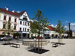 Svobody Square, historical centre | |
 Flag  Coat of arms | |
 Planá Location in the Czech Republic | |
| Coordinates: 49°52′6″N 12°44′25″E / 49.86833°N 12.74028°ECoordinates: 49°52′6″N 12°44′25″E / 49.86833°N 12.74028°E | |
| Country | |
| Region | Plzeň |
| District | Tachov |
| First mentioned | 1251 |
| Government | |
| • Mayor | Martina Němečková |
| Area | |
| • Total | 62.47 km2 (24.12 sq mi) |
| Elevation | 506 m (1,660 ft) |
| Population (2021-01-01)[1] | |
| • Total | 5,385 |
| • Density | 86/km2 (220/sq mi) |
| Time zone | UTC+1 (CET) |
| • Summer (DST) | UTC+2 (CEST) |
| Postal code | 348 15 |
| Website | www |

Planá (Czech pronunciation: [ˈplanaː]; German: Plan), also known as Planá u Mariánských Lázní, is a town in Tachov District in the Plzeň Region of the Czech Republic. It has about 5,400 inhabitants. It lies some 50 km (30 mi) to the west from the region capital of Plzeň. The town centre is well preserved and is protected by law as an urban monument zone.
Administrative parts[]
Villages of Křínov, Kříženec, Otín, Pavlovice, Svahy, Týnec, Vížka, Vysoké Sedliště and Zliv are administrative parts of Planá.
History[]
The first written mention of Planá is from 1251. Planá was located on an important trade route from Nuremberg to Cheb. The oldest part of Planá was built during the 13th and 14th century and at the end of the 14th century is was quite large town, surrounded by walls and a moat.[2]
Sights[]


The Svobody Square is in the town's historical core. The town hall was built in 1680–1685. The Baroque plague column with the statue of Saint John of Nepomuk on its top is from 1712. Most of the houses on the square are in Gothic or Renaissance style and are protected as cultural monuments.[3]
The oldest town's monument is the Church of Saints Peter and Paul from the 13th century. It is the nationwide important monument with unique frescoes and a rare Romanesque portal with an arched frieze.[3]
Church of the Assumption of the Virgin Mary is the largest church in Planá. It was built in the 13th–14th century, originally in the late Romanesque style.[3]
The Mining Museum is located in the Ondřej Schlick adit, which was excavated in the 16th century. It documents mining of silver ore in Planá and its surroundings, and existence of mint for minting silver coins, owned the Schlick noble family.[3]
The castle was continuously built and rebuilt from the 13th to the 20th century and therefore contains building elements from Gothic to the present. Between 1948 and 1991 it served as barracks of the border guard and since then it is abandoned and is crumbling. Its English garden is open to the public.[3]
Notable people[]
- Siegfried Becher (1806–1873), Austrian political economist
- Hans Tropsch (1889–1935), chemist
- Petr Pavel (born 1961), Czech Army General
- Zdeněk Štybar (born 1985), cyclo-cross racer
- David Vaněček (born 1991), footballer
- Dominik Kahun (born 1995), German ice-hockey player
Twin towns – sister cities[]
 Tirschenreuth, Germany
References[]
- ^ "Population of Municipalities – 1 January 2021". Czech Statistical Office. 2021-04-30.
- ^ "Historie Plané" (in Czech). Město Planá. Retrieved 2021-06-15.
- ^ Jump up to: a b c d e "Zajímavosti města" (in Czech). Město Planá. Retrieved 2021-06-15.
- ^ "Podpis partnerské smlouvy měst Planá a Tirschenreuth". plana.cz (in Czech). Město Planá. Retrieved 2020-08-04.
External links[]
| Wikimedia Commons has media related to Planá (Tachov District). |
| show Authority control |
|---|
This Plzeň Region location article is a stub. You can help Wikipedia by . |
- Populated places in Tachov District
- Cities and towns in the Czech Republic
- Plzeň Region geography stubs