Kšice
Kšice | |
|---|---|
Municipality | |
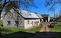
 Houses in the center of the village | |
 Kšice | |
| Coordinates: 49°47′55″N 12°59′52″E / 49.79861°N 12.99778°ECoordinates: 49°47′55″N 12°59′52″E / 49.79861°N 12.99778°E | |
| Country | |
| Region | Plzeň |
| District | Tachov |
| Area | |
| • Total | 15.42 km2 (5.95 sq mi) |
| Elevation | 488 m (1,601 ft) |
| Population (2006) | |
| • Total | 207 |
| • Density | 13/km2 (35/sq mi) |
| Postal code | 349 01 |
| Website | http://www.obec-ksice.cz/ |

Kšice (German: Kscheutz) is a village and municipality (obec) in Tachov District in the Plzeň Region of the Czech Republic.
The municipality covers an area of 15.42 square kilometres (5.95 sq mi), and has a population of 207 (as at 28 August 2006).
Kšice lies approximately 28 kilometres (17 mi) east of Tachov, 28 km (17 mi) west of Plzeň, and 107 km (66 mi) west of Prague.
History[]
The first mention of the village comes from the year 1369. Silver and lead was mined in the vicinity of the village in Mies mining district. At the end of the 19th century the last mine, on the road to Unola (Únehle), was closed down.
Until the abolition of the manorial system Kscheutz belonged to the manor of Trpísty-Třebel. The village had its own church, but was served by priests from Welperschitz (Erpužice).
After the Munich Agreement the village was annexed by the German Reich and belonged to the district of Mies until 1945. In 1939 324 people lived in Kscheutz.
Between 1 July 1980 and 1 January 1992 Kšice was a district of Stříbro .
Kšice was created around a village square with a pond. The Assumption Church dominates the townscape. Through various modifications their original appearance was lost, and during the communist rule it decayed. For some time repairs have been carried out on the building. The fixtures date back to the Baroque period.
Additional photographs[]
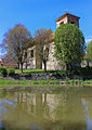
Church of the Assumption of the Virgin Mary
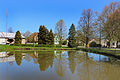
Common pond
Municipal office


References[]
| Wikimedia Commons has media related to Kšice. |
| Authority control: National libraries |
|---|
This Plzeň Region location article is a stub. You can help Wikipedia by . |
- Villages in Tachov District
- Plzeň Region geography stubs