Staré Sedliště
Staré Sedliště | |
|---|---|
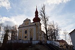 Church of Saints Procopius and Ulrich | |
 Flag  Coat of arms | |
 Staré Sedliště Location in the Czech Republic | |
| Coordinates: 49°44′49″N 12°42′9″E / 49.74694°N 12.70250°ECoordinates: 49°44′49″N 12°42′9″E / 49.74694°N 12.70250°E | |
| Country | |
| Region | Plzeň |
| District | Tachov |
| First mentioned | 1177 |
| Area | |
| • Total | 37.36 km2 (14.42 sq mi) |
| Elevation | 512 m (1,680 ft) |
| Population (2021-01-01)[1] | |
| • Total | 1,267 |
| • Density | 34/km2 (88/sq mi) |
| Time zone | UTC+1 (CET) |
| • Summer (DST) | UTC+2 (CEST) |
| Postal code | 348 01 |
| Website | www |

Staré Sedliště is a municipality and village in Tachov District in the Plzeň Region of the Czech Republic. It has about 1,300 inhabitants.
Staré Sedliště lies approximately 9 kilometres (6 mi) south-east of Tachov, 49 km (30 mi) west of Plzeň, and 129 km (80 mi) west of Prague.
Administrative parts[]
Villages of Labuť, Mchov, Nové Sedliště and Úšava are administrative parts of Staré Sedliště.
References[]
| Wikimedia Commons has media related to Staré Sedliště. |
| show Authority control |
|---|
This Plzeň Region location article is a stub. You can help Wikipedia by . |
Categories:
- Villages in Tachov District
- Plzeň Region geography stubs