Čachotín
Čachotín | |
|---|---|
Municipality | |
 | |
 Čachotín | |
| Coordinates: 49°41′34″N 15°36′35″E / 49.69278°N 15.60972°ECoordinates: 49°41′34″N 15°36′35″E / 49.69278°N 15.60972°E | |
| Country | |
| Region | Vysočina |
| District | Havlíčkův Brod |
| Area | |
| • Total | 6.3 km2 (2.4 sq mi) |
| Elevation | 572 m (1,877 ft) |
| Population (1.1.2014) | |
| • Total | 180 |
| • Density | 29/km2 (74/sq mi) |
| Postal code | 583 01 |

Čachotín [ˈtʃaxociːn] is a village and municipality (obec) in Havlíčkův Brod District in the Vysočina Region of the Czech Republic.
The municipality covers an area of 6.3 square kilometres (2.4 sq mi), and has a population of 182 (as at 3 July 2006).
Čachotín lies approximately 10 kilometres (6 mi) north of Havlíčkův Brod, 33 km (21 mi) north of Jihlava, and 96 km (60 mi) south-east of Prague.
Gallery[]
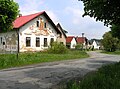
Main street

Municipal office


References[]
| Wikimedia Commons has media related to Čachotín. |
| Authority control: National libraries |
|---|
This Vysočina Region location article is a stub. You can help Wikipedia by . |
Categories:
- Villages in Havlíčkův Brod District
- Vysočina Region geography stubs