Ovesná Lhota
Ovesná Lhota | |
|---|---|
Municipality | |
 | |
 Flag  Coat of arms | |
 Ovesná Lhota | |
| Coordinates: 49°43′27″N 15°22′45″E / 49.72417°N 15.37917°ECoordinates: 49°43′27″N 15°22′45″E / 49.72417°N 15.37917°E | |
| Country | |
| Region | Vysočina |
| District | Havlíčkův Brod |
| Area | |
| • Total | 5.59 km2 (2.16 sq mi) |
| Elevation | 540 m (1,770 ft) |
| Population (1.1.2014) | |
| • Total | 193 |
| • Density | 35/km2 (89/sq mi) |
| Postal code | 582 91 |

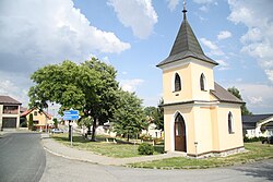
Ovesná Lhota is a village and municipality (obec) in Havlíčkův Brod District in the Vysočina Region of the Czech Republic.
The municipality covers an area of 5.59 square kilometres (2.16 sq mi), and has a population of 197 (as at 3 July 2006).
Ovesná Lhota lies approximately 20 kilometres (12 mi) north-west of Havlíčkův Brod, 40 km (25 mi) north-west of Jihlava, and 80 km (50 mi) south-east of Prague.
References[]
| Authority control: National libraries |
|---|
This Vysočina Region location article is a stub. You can help Wikipedia by . |
Categories:
- Villages in Havlíčkův Brod District
- Vysočina Region geography stubs