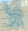
Łęg (river)
| Łęg | |
|---|---|
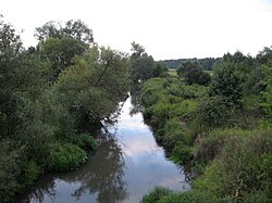 Łęg River near Kępie Zaleszańskie | |
| Location | |
| Country | Poland |
| Physical characteristics | |
| Source | |
| • location | Kolbuszowa Plateau |
| • coordinates | 50°10′33″N 21°57′08″E / 50.17583°N 21.95222°E |
| Mouth | |
• location | Vistula |
• coordinates | 50°41′25″N 21°49′19″E / 50.69028°N 21.82194°ECoordinates: 50°41′25″N 21°49′19″E / 50.69028°N 21.82194°E |
| Length | 85.51 km (53.13 mi) |
| Basin size | 960.2 km2 (370.7 sq mi) |
| Basin features | |
| Progression | Vistula→ Baltic Sea |

The Łęg[1] [wɛŋk] is a river in south-eastern Poland, a right tributary of the Vistula River, with a length of 85.51 kilometres (53 miles) and a basin area of 960.2 square kilometres (371 sq mi).[2] Its source is in the village of Styków in Podkarpackie Voivodeship.[2]
| Wikimedia Commons has media related to Łęg. |
Tributaries[]
Tributaries of the Łęg include:
- Czarna
- Turka
- Przyrwa
- Murynia
See also[]
- Rivers of Poland
References[]
- ^ General Geodesic Office of Poland. "Geographical nomenclature of Poland. Volume 1. Hydronyms. Part 1. Flowing water, springs, waterfalls" (PDF) (in Polish). p. 148. Retrieved 2021-02-05.
- ^ a b Hydroportal KZGW [2021-03-16]
Tributaries of the Vistula River | ||
|---|---|---|
| Forming rivers |
|  |
| Main tributaries of the left bank | ||
| Main tributaries of the right bank |
| |
| Distributary |
| |
Categories:
- Tributaries of the Vistula
- Rivers of Poland
- Rivers of Podkarpackie Voivodeship
- Łęg basin
- Poland river stubs