Nogat
| Nogat River | |
|---|---|
 | |
| Location | |
| Country | Poland |
| Physical characteristics | |
| Source | |
| • location | Distributary of the Vistula River near Biała Góra |
| • coordinates | 53°54′43″N 18°52′47″E / 53.91194°N 18.87972°E |
| Mouth | |
• location | Vistula Lagoon |
• coordinates | 54°16′38″N 19°15′38″E / 54.27722°N 19.26056°ECoordinates: 54°16′38″N 19°15′38″E / 54.27722°N 19.26056°E |
| Length | 62 km (39 mi) |
| Basin size | 1,130 km2 (440 sq mi) |

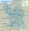
The Nogat is a 62 km long delta branch of the Vistula River. Unlike the main river, it does not empty into Gdańsk Bay but rather into the Vistula Lagoon.
The Nogat has its origin near the city of Biała Góra as a distributary of the Vistula River. Shortly after the river Liwa flows into the Nogat. Then the river passes Malbork and winds NE towards Elbląg (but does not reach the city). NW of Elbląg the Nogat flows into the SW part of the Vistula Lagoon.

Malbork Castle on the Nogat
During the interwar period, the Nogat formed the German boundary with the Free State of Danzig.
References[]
| Wikimedia Commons has media related to Nogat. |
Tributaries of the Vistula River | ||
|---|---|---|
| Forming rivers |
|  |
| Main tributaries of the left bank | ||
| Main tributaries of the right bank |
| |
| Distributary |
| |
Categories:
- Vistula basin
- Rivers of Poland
- Rivers of Pomeranian Voivodeship
- Rivers of Warmian-Masurian Voivodeship
- Poland river stubs