Wisłoka
| Wisłoka | |
|---|---|
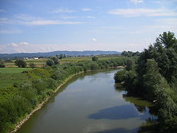 Wisłoka in Pilzno | |
| Location | |
| Country | Poland |
| Physical characteristics | |
| Mouth | |
• location | Vistula |
• coordinates | 50°26′16″N 21°23′07″E / 50.43778°N 21.38528°ECoordinates: 50°26′16″N 21°23′07″E / 50.43778°N 21.38528°E |
| Length | 173 km (107 mi) |
| Basin size | 4,100 km2 (1,600 sq mi) |
| Discharge | |
| • average | 35.5 m3/s (1,250 cu ft/s) |
| Basin features | |
| Progression | Vistula→ Baltic Sea |


Wisłoka in Mielec
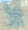
The Wisłoka is a river in south-eastern Poland, a tributary of the Vistula river, with a length of 173 kilometres (107 miles) and a basin area of 4,100 square kilometres (1,583 sq mi).[1] The highest elevations reach an altitude of 370 metres (1,213.91 ft), while the lowest point in the valley of the river Wisłoka lies at an altitude of 250 metres (820.21 ft) above sea level.[2]
Towns and townships around Wisłoka[]
Tributaries[]
Tributaries of the Wisłoka include:
- Jasiołka
- Tuszymka
- Wielopolka
- Ropa
- Grabinianka
See also[]
References[]
- Bibliography
- Fastnacht, Professor Adam. – Slownik Historyczno-Geograficzny Ziemi Sanockiej w Sredniowieczu, Kraków 2002, ISBN 83-88385-14-3
- Notes
- ^ Statistical Yearbook of the Republic of Poland 2017, Statistics Poland, p. 85-86
- ^ Bulletin. Instytut Geologiczny (Poland). 1956. p. 188
See also[]
- Rivers of Poland
| show Tributaries of the Vistula River |
|---|
| show Authority control |
|---|
This Podkarpackie Voivodeship location article is a stub. You can help Wikipedia by . |
Categories:
- Tributaries of the Vistula
- Rivers of Poland
- Rivers of Podkarpackie Voivodeship
- Podkarpackie geography stubs
- Poland river stubs