Skawa
| Skawa | |
|---|---|
 Skawa near Maków Podhalański | |
| Location | |
| Country | Poland |
| State | Lesser Poland Voivodeship |
| Physical characteristics | |
| Source | Spytkowice, Nowy Targ County 49°34′35″N 19°49′7″E / 49.57639°N 19.81861°E |
| Mouth | Vistula at Smolice 50°1′52″N 19°27′12″E / 50.03111°N 19.45333°ECoordinates: 50°1′52″N 19°27′12″E / 50.03111°N 19.45333°E |
| Length | 96 km (60 mi) |
| Basin size | 1,160 km2 (450 sq mi) |
| Discharge | |
| • average | 11.1 m3/s (390 cu ft/s) |
| Basin features | |
| Progression | Vistula→ Baltic Sea |

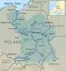
Skawa (German: Schaue) is a river in southern Poland, a right tributary of the Vistula. It originates in the Western Carpathians (Beskids), is 96 km long and drains 1,160 km². It passes several towns: Jordanów, Maków Podhalański, Sucha Beskidzka, Wadowice and Zator, and whole river is located within the territory of Lesser Poland Voivodeship.
Skawa has its source in the Spytkowice Pass, at the height of 700 meters above sea level. Since it is a mountain river and causes frequent floodings, its regulation has for years been a priority. Construction of a dam at a village of Świnna Poręba is to be completed by 2014. A reservoir will be created, which will prevent future floods, and which will serve as a source of drinking water for the local population. Skawa flows into the Vistula near the village of Smolice.
Sources[]
See also[]
| hide Tributaries of the Vistula River | ||
|---|---|---|
| Forming rivers |
|  |
| Main tributaries of the left bank | ||
| Main tributaries of the right bank |
| |
| Distributary |
| |
| Wikimedia Commons has media related to Skawa. |
- Tributaries of the Vistula
- Rivers of Poland
- Rivers of Lesser Poland Voivodeship