Bzura
| Bzura | |
|---|---|
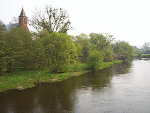 The Bzura in Kozłów Biskupi 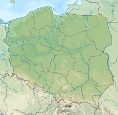 Bzura (river mouth) | |
| Location | |
| Country | Poland |
| Physical characteristics | |
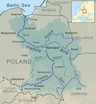
| Mouth | |
• location | Vistula |
• coordinates | 52°22′28″N 20°12′05″E / 52.3744°N 20.2013°ECoordinates: 52°22′28″N 20°12′05″E / 52.3744°N 20.2013°E |
| Length | 173 km (107 mi) |
| Basin size | 7,764 km2 (2,998 sq mi) |
| Discharge | |
| • average | 28.6 m3/s (1,010 cu ft/s) |
| Basin features | |
| Progression | Vistula→ Baltic Sea |

The Bzura is a river in central Poland, a tributary of the Vistula river (in Wyszogród), with a length of 173 kilometres and a basin area of 7,764 km2.[1] It was noteworthy during the Second World War as Polish forces made a major stand against the Wehrmacht in an attempt to halt the German advance on Warsaw (Battle of the Bzura).
Towns and townships[]
Right tributaries[]
Left tributaries[]
See also[]
- Rivers of Poland
- Battle of the Bzura
References[]
- ^ Statistical Yearbook of the Republic of Poland 2017, Statistics Poland, p. 85-86
| show Tributaries of the Vistula River |
|---|
| Authority control |
|---|
Categories:
- Tributaries of the Vistula
- Rivers of Poland
- Rivers of Masovian Voivodeship
- Rivers of Łódź Voivodeship
- Poland river stubs