Alpine Way
Alpine Way | |
|---|---|
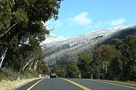 | |
Alpine Way, near Thredbo | |
 | |
 East end West end | |
| Coordinates | |
| General information | |
| Type | Road |
| Length | 121 km (75 mi)[1] |
| Opened | 1950s |
| Major junctions | |
| East end | |
| Tooma Road | |
| West end |
|
| Location(s) | |
| Major suburbs |
|
| Restrictions | |
| General | Carrying snow chains may be required at certain times of the year. |
| Highway system | |

The Alpine Way is a 121-kilometre (75 mi) rural road located in the Snowy Mountains region of New South Wales, Australia. The road connects Jindabyne in the east to the New South Wales / Victorian border in the west, crossing the Murray River, near Bringenbrong / Upper Towong. The route does not carry an official shield designation.
Route[]
The eastern terminus of the Alpine Way is at a "T" intersection with Kosciuszko Rd, 3 kilometres (1.9 mi) west of Jindabyne on the eastern side of the Snowy Mountains.
The road winds its way generally west to adjacent the Thredbo River, before heading south-west past Thredbo and then climbing & crossing the crest of the Great Dividing Range at Dead Horse Gap at an altitude of 1,580 metres (5,180 ft) then a winding descent to & crossing Snowy Creek @ 580 metres (1,900 ft) very near the Murray River / Victorian Border.
Thereafter, it continues around the western side of the range heading north along the upper reaches of the Murray River Tributaries, past the Geehi River & Swampy Plain River Junction to Khancoban, before eventually crossing the Murray and reaching its western terminus and connecting with the Murray Valley Highway (B400) on the river's southern bank, within Victoria.[2]
The highway was initially built in the 1950s as part of the access for the Snowy Mountains Scheme. However, the paving of it was only completed approximately forty years later in the 1990s.
The majority of the road is contained within the Kosciuszko National Park[3] and since 2004 has been maintained by Roads & Maritime Services.[4][5]
The road has no major intersections.
Road restrictions[]
Road restrictions in the region require all two-wheel drive vehicles carry snow chains between Thredbo and Tom Groggin from the long weekends marking the Queen's Official Birthday in June and the Labour Day in October. It is also quite possible that snow chains may be needed to drive safely along other (more dangerous) parts of Alpine Way.[6][7]
See also[]
- List of highways in New South Wales
- 1997 Thredbo landslide
- Barry Way
References[]
- ^ 6532 Kosciuszko Road, Jindabyne NSW 2627, Australia to Murray Valley Highway, Towong Upper VIC 3707, Australia (Map). Google Maps. 2016. Retrieved 18 November 2016.
- ^ "Kosciuszko Alpine Way". Destination NSW. Government of New South Wales. 2016. Archived from the original on 13 November 2016. Retrieved 18 November 2016.
- ^ "Kosciuszko – Alpine Way drive". NSW National Parks and Wildlife Service. Government of New South Wales. 2016. Archived from the original on 19 November 2016. Retrieved 18 November 2016.
- ^ "Schedule of Classified Roads and Unclassified Regional Roads" (PDF). Roads & Maritime Services. Government of New South Wales. January 2014. p. 27. Archived (PDF) from the original on 29 March 2017. Retrieved 18 November 2016.
- ^ "Annual Report 2004" (PDF). Roads & Traffic Authority. Government of New South Wales. 2004. p. 95. Archived (PDF) from the original on 14 February 2017. Retrieved 18 November 2016.
- ^ "Driving in the snow". NSW Environment and Heritage. Government of New South Wales. 9 July 2011. Archived from the original on 9 February 2013.
- ^ "Kosciuszko – Alpine Way drive: Getting there and parking". NSW National Parks and Wildlife Service. Government of New South Wales. 2016. Archived from the original on 19 November 2016. Retrieved 18 November 2016.
External links[]
Route map:
| ( • help)
|
| Townships and Villages | |
|---|---|
| Localities and rural places |
|
| National parks and other natural features | |
| Rivers and other watercourses | |
| Dams and/or associated reservoirs | |
| Mountain ranges | |
| Attractions |
|
Main Article: Local government areas of New South Wales | |
- 1950s establishments in Australia
- Highways in New South Wales
- Snowy Mountains