Jenolan Caves Road
Jenolan Caves Road | |
|---|---|
 | |
| Jenolan Caves Road, Hartley | |
| General information | |
| Type | Rural road |
| Length | 51 km (32 mi) |
| Major junctions | |
| North end | |
| Southwest end | Edith Road, Jenolan, New South Wales |
| Location(s) | |
| Major settlements | Lowther Hampton Jenolan |
Jenolan Caves Road is a rural road in New South Wales, Australia, linking the Great Western Highway at Hartley to Edith Road at Jenolan.
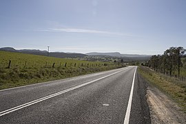
The road is fully sealed across its entire length. The road can get as narrow as one lane on the 5-Mile, Grand Arch, and 2-Mile sections of the road. But the majority of the road is two lanes wide.
The road is a part of Tourist Drive 1 linking the Blue Mountains to Bathurst via Oberon and Hampton. Also, the road is designated as Main Road 253.[1]
Route[]
The road starts at the intersection of the Great Western Highway and Blackmans Creek Road, then travels south and crosses the Coxs River (Glenroy Bridge). then it travels southwest and ascends Mount Blaxland then continues to Hampton and winds to Duckmaloi Road intersection. Then it winds south to the 5-Mile section which descends to the Grand Arch. Then it goes through Jenolan Caves then leads to a parking lot at Jenolan Caves House. Then it continues northwest on the 2-Mile section then turning into Edith Road at the Kanangra Walls Road intersection.
Closures[]
The road has been closed several times over the years due to bushfires and landslips. Two notable closures were the section between Hampton and Jenolan Caves between January and June 2020 due to bushfire damage and landslips from heavy rain and floods. The same section has been closed since March 2021 due to landslips and parts of the road washed away due to heavy rain and flooding.[2] On May 25th, 2021 the road has been reopened at Hampton with Stop / Slow restrictions. The 5-Mile section is still closed for now. The 2-Mile section was reopened on May 10th, 2021.
Major intersections[]
| LGA | Location | km[3] | mi | Destinations | Notes |
|---|---|---|---|---|---|
| Lithgow | Hartley | 0 | 0.0 | east - Mount Victoria | Northern end of the road. |
| Coxs River | 2.1 | 1.3 | Glenroy Bridge | ||
| Lithgow | Hartley | 6.2 | 3.9 | McKanes Falls Road - north - Lithgow | |
| Lowther | 12.2 | 7.6 | Lowther Siding Road - east - Little Hartley | ||
| Hampton | 19.4 | 12.1 | Hampton Road - north - Rydal | ||
| Hampton | 23.7 | 14.7 | Duckmaloi Road - west - Oberon | ||
| Oberon | Jenolan | 51 | 32 | Kanangra Walls Rd - South - Kanangra-Boyd National Park | Southwestern end of the road. Continues northwest as Edith Road. |
| 1.000 mi = 1.609 km; 1.000 km = 0.621 mi | |||||
See also[]
- Highways in Australia
- List of highways in New South Wales
- Fish River
References[]
- ^ "Schedule of Classified Roads and Unclassified Regional Roads - gazetted road 253" (PDF). Roads & Maritime Services. April 2017. Retrieved 29 October 2018.
- ^ "- Landslides close Jenolan Caves precinct again as terrible luck continues". Oberon Review. March 2021. Retrieved 3 May 2021.
- ^ Google. "Jenolan Caves Road" (Map). Google Maps. Google.
- Highways in New South Wales
- Oberon Council