Atlas Tract
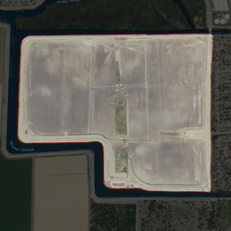 USGS aerial imagery of the Atlas Tract | |
 Atlas Tract | |
| Geography | |
|---|---|
| Location | Northern California |
| Coordinates | 38°02′09″N 121°22′58″W / 38.03583°N 121.38278°W[1]Coordinates: 38°02′09″N 121°22′58″W / 38.03583°N 121.38278°W[1] |
| Adjacent bodies of water | Sacramento–San Joaquin River Delta |
| Area | 360 acres (150 ha)[2]: 325 |
| Highest elevation | 0 ft (0 m)[1] |
| Administration | |
United States | |
| State | |
| County | San Joaquin |


The Atlas Tract (formerly known as the Hartland Tract)[3] is an island in the Sacramento–San Joaquin River Delta, in San Joaquin County, California. It has been used for agriculture since it was first reclaimed in the late 19th century.
Geography[]
The Atlas Tract's boundaries are coterminous with Reclamation District 2126[4][2] (which was formed in 1989);[4]: 325 they are located entirely within the city of Stockton.[4]: 402 The Atlas Tract is surrounded by 3.08 miles (5.0 km) of levees.[4]: 402 Its coordinates are 38°02′09″N 121°22′58″W / 38.03583°N 121.38278°W[1], and the United States Geological Survey measured its elevation as 0 ft (0 m) in 1981.[1] It appears on a 1952 USGS map of the area.[5]
History[]
In the 1880s, the Atlas Tract was first developed and planted by Charles E. Knapp.[6] At the time, its largest landowners were Judge Cooney and Dr. S. F. Long, of San Francisco.[6] By 1915, livestock were being raised on the tract by M. Goldstein;[7] in 1935, the tract was still used for ranching, and was the location of the Biaga ranch.[8]
In 1967, the First Stockton Corporation proposed to develop a man-made marina and lake there; the Stockton Planning Commission endorsed this proposal, but the county of San Joaquin had delayed approval of excavation permits.[9] The marina and park were to be constructed by removing 4,350,000 cubic yards of material (which was to be used for nearby freeway construction).[3] In December, it was announced that county officials had approved the plan, which was expected to be completed around 1970.[10] As of 1993, no such development had occurred.[11] In 2006, the Atlas Tract was aerially sprayed to kill mosquitoes suspected of carrying the West Nile virus.[12]
As of 2017, the Atlas Tract was used solely for agriculture (being used to grow small grains and hay).[4]: 325 [4]: 340 At that time, there were no residences on the land, but a large-scale residential development had been proposed on the tract (with potentially as many as 1,400 lots).[4]: 402 In 2015, the population was 0; the San Joaquin County Local Agency Formation Commission projected a population of 42,000 by 2045.[4]: 340
References[]
- ^ a b c d U.S. Geological Survey Geographic Names Information System: Atlas Tract
- ^ a b "Reclamation Districts Map" (PDF). San Joaquin County Geographic Information Systems. San Joaquin County. 16 September 2020. Archived (PDF) from the original on 24 November 2020. Retrieved 24 February 2021.
- ^ a b "Big Excavation Permit Sought". Tracy Press. Tracy, California. 1967-11-01. p. 13.
- ^ a b c d e f g h "Municipal Service Review: Selected San Joaquin County Reclamation Districts" (PDF). San Joaquin Local Agency Formation Commission. E Mulberg & Associates. 18 March 2018. Archived (PDF) from the original on 14 March 2021. Retrieved 24 February 2021.
- ^ United States Geological Survey (1952). "Terminous Quadrangle, California" (Map). United States Department of the Interior Geological Survey. 1:24000.
- ^ a b "New Yorker Recalls Pioneer Land Deals". The Fresno Morning Republican. Fresno, California. 1912-04-29. p. 3.
- ^ "Mortgages". Stockton Daily Evening Record. Stockton, California. 1915-03-18. p. 9.
- ^ "Axe Killing Results From Delta Sport". Stockton Independent. Stockton, California. 1935-03-19. p. 2.
- ^ "County Zoners Will Decide On Stockton Marina". The Sacramento Bee. Sacramento, California. 1967-10-30. p. 22.
- ^ "SJ Approves Plan Creating 275-Acre Lake". The Modesto Bee. Modesto, California. 1967-12-01. p. 19. Retrieved 2021-11-17 – via Newspapers.com.
- ^ United States Geological Survey (1993). "Lodi, California" (Map). United States Department of the Interior Geological Survey. 1:100000.
- ^ "Virus". The Escalon Times. Escalon, California. 2006-08-02. p. 10.
Map: Islands of Suisun Bay and the Sacramento–San Joaquin River Delta | |
|---|---|
 Victoria Upper Jones Lower Jones Winter Van Sickle Venice Bradford Twitchell Roe Simmons Wheeler Merritt Rough and Ready (islands of the San Francisco Bay Area) |
San Francisco Bay watershed | ||
|---|---|---|
| Outline |
|  |
| Subdivisions |
| |
| Waterways |
| |
| Parks and protected areas |
| |
| Islands and peninsulas |
| |
| Wetlands |
| |
| Bridges and tubes |
| |
| Ferries | ||
| Ports and marinas |
| |
| Other |
| |
| ||
- Islands of San Joaquin County, California
- Islands of the Sacramento–San Joaquin River Delta
- Islands of Northern California