Little Holland Tract
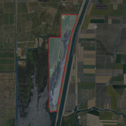 USGS aerial imagery of Little Holland Tract | |
 Little Holland Tract | |
| Geography | |
|---|---|
| Location | Northern California |
| Coordinates | 38°19′27″N 121°39′20″W / 38.32417°N 121.65556°W[1]Coordinates: 38°19′27″N 121°39′20″W / 38.32417°N 121.65556°W[1] |
| Adjacent bodies of water | Sacramento–San Joaquin River Delta |
| Highest elevation | 13 ft (4 m)[1] |
| Administration | |
United States | |
| State | |
| County | Yolo |


The Little Holland Tract is a partially submerged island in the Sacramento–San Joaquin River Delta, in Yolo County, California.[2] Its coordinates are 38°19′27″N 121°39′20″W / 38.32417°N 121.65556°W[1], and the United States Geological Survey gave its elevation as 13 ft (4.0 m) in 1981.[1] It appears on a 1952 USGS map as a large rectangular tract; by 1978, survey maps show it cut diagonally by the Sacramento River Deep Water Ship Channel.[3][4]
References[]
- ^ a b c d U.S. Geological Survey Geographic Names Information System: Little Holland Tract
- ^ "More islands submerged in Delta floods". North East Bay Independent and Gazette. Berkeley, California. 1980-02-22. p. 1.
- ^ United States Geological Survey (1952). "Liberty Island Quadrangle, California" (Map). United States Department of the Interior Geological Survey. 1:24000.
- ^ United States Geological Survey (1978). "Liberty Island Quadrangle, California" (Map). United States Department of the Interior Geological Survey. 1:24000.
Map: Islands of Suisun Bay and the Sacramento–San Joaquin River Delta | |
|---|---|
 Victoria Upper Jones Lower Jones Winter Van Sickle Venice Bradford Twitchell Roe Simmons Wheeler Merritt Rough and Ready (islands of the San Francisco Bay Area) |
San Francisco Bay watershed | ||
|---|---|---|
| Outline |
|  |
| Subdivisions |
| |
| Waterways |
| |
| Parks and protected areas |
| |
| Islands and peninsulas |
| |
| Wetlands |
| |
| Bridges and tubes |
| |
| Ferries | ||
| Ports and marinas |
| |
| Other |
| |
| ||
This Yolo County, California-related article is a stub. You can help Wikipedia by . |
Categories:
- Islands of Yolo County, California
- Islands of the Sacramento–San Joaquin River Delta
- Islands of Northern California
- Yolo County, California geography stubs