Long Island (California)
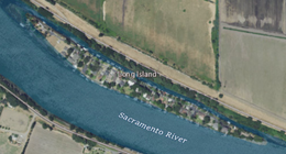 USGS aerial imagery of Long Island in the w:Sacramento River; to the south is w:Brannan Island, and to the north a bridge connects to Grand Island. | |
 Long Island | |
| Geography | |
|---|---|
| Location | Northern California |
| Coordinates | 38°10′01″N 121°37′30″W / 38.16694°N 121.62500°W[1]Coordinates: 38°10′01″N 121°37′30″W / 38.16694°N 121.62500°W[1] |
| Adjacent bodies of water | Sacramento–San Joaquin River Delta |
| Highest elevation | 7 ft (2.1 m)[1] |
| Administration | |
United States | |
| State | |
| County | Sacramento |


Long Island is a small island in the Sacramento–San Joaquin River Delta.[2][3] It is part of Sacramento County, California. Its coordinates are 38°10′01″N 121°37′30″W / 38.16694°N 121.62500°W[1], and the United States Geological Survey measured its elevation as 7 ft (2.1 m) in 1981.[1] It appears on 1978 USGS maps of the area.[4][5]
References[]
- ^ a b c d U.S. Geological Survey Geographic Names Information System: Long Island
- ^ "Sacramento County Project and Policy Planning Commissions". The Sacramento Bee. Sacramento, California. 1977-07-07. p. 27.
- ^ "Delta dikes stand against tides". Oakland Tribune. Oakland, California. 1980-01-18. p. 12.
- ^ United States Geological Survey (1978). "Rio Vista Quadrangle, California" (Map). United States Department of the Interior Geological Survey. 1:24000.
- ^ United States Geological Survey (1978). "Isleton Quadrangle, California" (Map). United States Department of the Interior Geological Survey. 1:24000.
Map: Islands of Suisun Bay and the Sacramento–San Joaquin River Delta | |
|---|---|
 Victoria Upper Jones Lower Jones Winter Van Sickle Venice Bradford Twitchell Roe Simmons Wheeler Merritt Rough and Ready (islands of the San Francisco Bay Area) |
San Francisco Bay watershed | ||
|---|---|---|
| Outline |
|  |
| Subdivisions |
| |
| Waterways |
| |
| Parks and protected areas |
| |
| Islands and peninsulas |
| |
| Wetlands |
| |
| Bridges and tubes |
| |
| Ferries | ||
| Ports and marinas |
| |
| Other |
| |
| ||
This Sacramento County, California-related article is a stub. You can help Wikipedia by . |
Categories:
- Islands of Sacramento County, California
- Islands of the Sacramento–San Joaquin River Delta
- Islands of Northern California
- Sacramento Valley geography stubs