French Island (California)
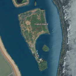 USGS aerial imagery of French Island; Hastings Tract is across to the west, and the flooded Liberty Island is across to the east. | |
 French Island | |
| Geography | |
|---|---|
| Location | Northern California |
| Coordinates | 38°15′51″N 121°41′38″W / 38.26417°N 121.69389°W[1]Coordinates: 38°15′51″N 121°41′38″W / 38.26417°N 121.69389°W[1] |
| Adjacent bodies of water | Sacramento–San Joaquin River Delta |
| Highest elevation | 0 ft (0 m)[1] |
| Administration | |
United States | |
| State | |
| County | Solano |


French Island seen from the southeast in a 2018 aerial photo
French Island is a small island in the Sacramento–San Joaquin River Delta.[2] It is part of Solano County, California. Its coordinates are 38°15′51″N 121°41′38″W / 38.26417°N 121.69389°W[1], and the United States Geological Survey measured its elevation as 0 ft (0 m) in 1981.[1] It appears on USGS maps in 1952 and 1978, with the same shape and elevation.[3][4]
References[]
- ^ a b c d U.S. Geological Survey Geographic Names Information System: French Island
- ^ "Species". Napa Valley Register. Napa, California. 2020-04-17. p. B3.
- ^ United States Geological Survey (1952). "Liberty Island Quadrangle, California" (Map). United States Department of the Interior Geological Survey. 1:24000.
- ^ United States Geological Survey (1978). "Liberty Island Quadrangle, California" (Map). United States Department of the Interior Geological Survey. 1:24000.
Map: Islands of Suisun Bay and the Sacramento–San Joaquin River Delta | |
|---|---|
 Victoria Upper Jones Lower Jones Winter Van Sickle Venice Bradford Twitchell Roe Simmons Wheeler Merritt Rough and Ready (islands of the San Francisco Bay Area) |
San Francisco Bay watershed | ||
|---|---|---|
| Outline |
|  |
| Subdivisions |
| |
| Waterways |
| |
| Parks and protected areas |
| |
| Islands and peninsulas |
| |
| Wetlands |
| |
| Bridges and tubes |
| |
| Ferries | ||
| Ports and marinas |
| |
| Other |
| |
| ||
This Solano County, California-related article is a stub. You can help Wikipedia by . |
Categories:
- Islands of Solano County, California
- Islands of the Sacramento–San Joaquin River Delta
- Islands of Northern California
- San Francisco Bay Area geography stubs