Chipps Island
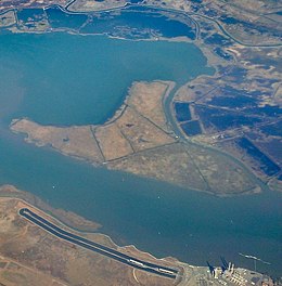 Chipps Island from the south, in an aerial photo from 2015 | |
 Chipps Island | |
| Geography | |
|---|---|
| Location | Northern California |
| Coordinates | 38°03′19″N 121°54′43″W / 38.05528°N 121.91194°W[1]Coordinates: 38°03′19″N 121°54′43″W / 38.05528°N 121.91194°W[1] |
| Adjacent bodies of water | Suisun Bay |
| Administration | |
United States | |
| State | |
| County | Solano |


United States Geological Survey aerial photo of Chipps Island.
Chipps Island is a small island in Suisun Bay, California.[2][3] It is part of Solano County. It is also known as Knox Island,[1] Its coordinates are 38°03′19″N 121°54′43″W / 38.05528°N 121.91194°W[1] by which name it appears on an 1850 survey map of the San Francisco Bay area made by Cadwalader Ringgold,[4] as well as an 1854 map of the area by Henry Lange.[5]

A photo of Chipps Island taken in March 2021 from Bay Point. Van Sickle Island can be seen to the north.
References[]
- ^ a b c U.S. Geological Survey Geographic Names Information System: Chipps Island
- ^ California State Automobile Association (1999). San Francisco Bay Region (Map). 1:190,000. American Automobile Association.
- ^ "State Resets Suisun Bay Oil-Gas Bidding Date". The Sacramento Bee. Sacramento, California. 1967-11-08. p. 39.
- ^ Ringgold, Cadwalader; Stuart, Fred D.; Everett, Chas.; Harrison (1850). "General Chart embracing Surveys of the Farallones Entrance to the Bay of San Francisco, Bays of San Francisco and San Pablo, Straits of Carquines and Suisun Bay, and the Sacramento and San Joaquin Rivers, to the Cities of Sacramento and San Joaquin, California". David Rumsey Map Collection. San Francisco Common Council. Archived from the original on 7 July 2017. Retrieved 25 February 2021.
- ^ Lange, Henry (1854). "Bai San Francisco und Vereinigung des Sacramento mit dem San Joaquin". David Rumsey Map Collection. George Westermann. Archived from the original on 10 March 2016. Retrieved 25 February 2021.
Map: Islands of Suisun Bay and the Sacramento–San Joaquin River Delta | |
|---|---|
 Victoria Upper Jones Lower Jones Winter Van Sickle Venice Bradford Twitchell Roe Simmons Wheeler Merritt Rough and Ready (islands of the San Francisco Bay Area) |
San Francisco Bay watershed | ||
|---|---|---|
| Outline |
|  |
| Subdivisions |
| |
| Waterways |
| |
| Parks and protected areas |
| |
| Islands and peninsulas |
| |
| Wetlands |
| |
| Bridges and tubes |
| |
| Ferries | ||
| Ports and marinas |
| |
| Other |
| |
| ||
This Solano County, California-related article is a stub. You can help Wikipedia by . |
Categories:
- Islands of the San Francisco Bay Area
- Islands of Northern California
- Islands of Solano County, California
- Islands of Suisun Bay
- San Francisco Bay Area geography stubs