Barail Range
| Barail Range | |
|---|---|
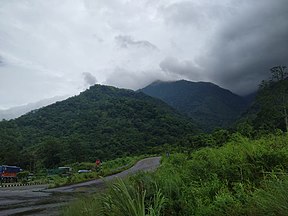 The Barail Range in Assam | |
| Highest point | |
| Peak | , , , , |
| Elevation | elevation of mahadevtila peak is approx.1840 metres from sea level |
| Coordinates | 25°16′27″N 93°20′51″E / 25.27417°N 93.34750°E |
| Dimensions | |
| Length | 720 km (450 mi) |
| Naming | |
| Pronunciation | Hindi pronunciation: [ bo ra il] |
| Geography | |
 Map showing the range
| |
| Country | India |
| States | Assam, Meghalaya, Manipur and Nagaland |
| Region | North East India |
| Rivers | Barak, Brahmaputra and Kopili |
| Settlements | Dima Hasao, Shillong, Diphu and Silchar |
| Range coordinates | 25°00′N 73°30′E / 25°N 73.5°ECoordinates: 25°00′N 73°30′E / 25°N 73.5°E |
| Geology | |
| Orogeny | Himalayan Orogeny |
| Type of rock | Sandstone |

The Barail Range is a tertiary mountain range in Northeast India with an area of approximately 80,000 ha between Brahmaputra and Barak basins located in Dima Hasao district of Assam stretch across to Meghalaya on the west, Nagaland and Manipur on the east .[1][2]
References[]
- ^ "BirdLife Data Zone". datazone.birdlife.org. Retrieved 9 January 2021.
- ^ "Barail Range of Assam | UPSC | North East India Info". Retrieved 9 January 2021.
This Asia mountain, mountain range, or peak related article is a stub. You can help Wikipedia by . |
Categories:
- Mountain ranges of India
- Dima Hasao district
- Asia mountain stubs