Bradys Bend Township, Armstrong County, Pennsylvania
Bradys Bend Township, Pennsylvania | |
|---|---|
 Along the Allegheny River; Bradys Bend Township is the lower area at left | |
 Map of Armstrong County, Pennsylvania highlighting Bradys Bend Township | |
 Map of Armstrong County, Pennsylvania | |
| Country | United States |
| State | Pennsylvania |
| County | Armstrong |
| Settled | 1784 |
| Incorporated | 1845 |
| Area | |
| • Total | 12.61 sq mi (32.67 km2) |
| • Land | 12.61 sq mi (32.67 km2) |
| • Water | 0.00 sq mi (0.00 km2) |
| Population (2010) | |
| • Total | 773 |
| • Estimate (2018)[2] | 724 |
| • Density | 58.11/sq mi (22.44/km2) |
| Time zone | UTC-5 (Eastern (EST)) |
| • Summer (DST) | UTC-4 (EDT) |
| FIPS code | 42-005-08152 |
Bradys Bend Township is a township in Armstrong County, Pennsylvania, United States. The population was 773 at the 2010 census.[3]
History[]
The Bradys Bend Iron Company Furnaces and St. Stephen's Church are listed on the National Register of Historic Places.[4]

Bradys Bend Iron Company Furnace
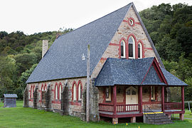
St. Stephen's Church


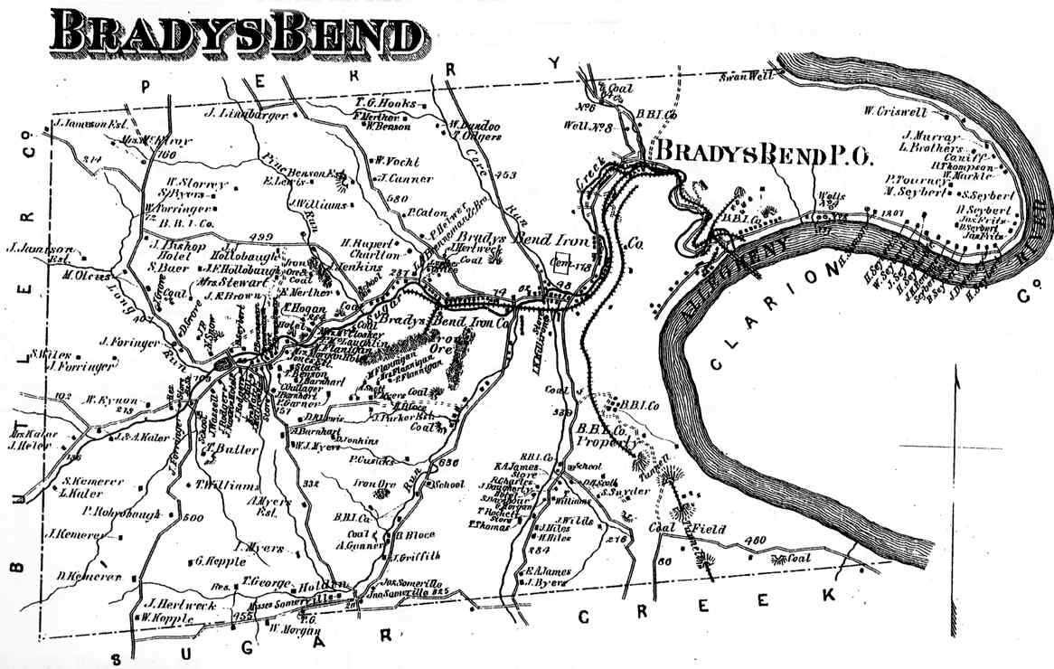
Brady's Bend Township appears in the 1876 Atlas of Armstrong County, Pennsylvania.[5]
Geography[]
According to the United States Census Bureau, the township has a total area of 12.6 square miles (32.7 km2), all of it land.[3]
Recreation[]
Portions of the Pennsylvania State Game Lands Number 105 are located in Bradys Bend Township.[6][7]
Demographics[]
| Historical population | |||
|---|---|---|---|
| Census | Pop. | %± | |
| 2010 | 773 | — | |
| 2018 (est.) | 724 | [2] | −6.3% |
| U.S. Decennial Census[8] | |||
As of the census[9] of 2000, there were 939 people, 392 households, and 279 families residing in the township. The population density was 73.9 people per square mile (28.5/km2). There were 582 housing units at an average density of 45.8/sq mi (17.7/km2). The racial makeup of the township was 98.72% White, 0.53% African American, 0.21% Asian, and 0.53% from two or more races.
There were 392 households, out of which 29.1% had children under the age of 18 living with them, 57.7% were married couples living together, 8.2% had a female householder with no husband present, and 28.8% were non-families. 25.3% of all households were made up of individuals, and 14.0% had someone living alone who was 65 years of age or older. The average household size was 2.38 and the average family size was 2.82.
The median age of 41 years was slightly more than that of the county of 40 years. The distribution was 21.7% under the age of 18, 5.6% from 18 to 24, 29.0% from 25 to 44, 27.9% from 45 to 64, and 15.8% who were 65 years of age or older. The median age was 41 years. For every 100 females there were 105.0 males. For every 100 females age 18 and over, there were 97.6 males.
The median income for a household in the township was $29,286, and the median income for a family was $38,036. Males had a median income of $28,594 versus $19,205 for females. The per capita income for the township was $17,797. About 13.1% of families and 17.3% of the population were below the poverty line, including 25.8% of those under age 18 and 15.2% of those age 65 or over.
Cemeteries[]
References[]
| Wikimedia Commons has media related to Bradys Bend Township, Armstrong County, Pennsylvania. |
- ^ "2016 U.S. Gazetteer Files". United States Census Bureau. Retrieved Aug 13, 2017.
- ^ a b Bureau, U. S. Census. "U.S. Census website". United States Census Bureau. US Census Bureau. Retrieved 30 November 2019.
- ^ a b "Geographic Identifiers: 2010 Demographic Profile Data (G001): Bradys Bend township, Armstrong County, Pennsylvania". U.S. Census Bureau, American Factfinder. Archived from the original on February 12, 2020. Retrieved July 31, 2013.
- ^ "National Register Information System". National Register of Historic Places. National Park Service. July 9, 2010.
- ^ "Atlas of Armstrong County Pennsylvania, page 29". Pomeroy, Whitman & Co. 1876. Retrieved 9 November 2018.
- ^ https://viewer.nationalmap.gov/advanced-viewer/ The National Map, retrieved 13 September 2018
- ^ Pennsylvania State Game Lands, retrieved 15 September 2018
- ^ "Census of Population and Housing". Census.gov. Retrieved June 4, 2016.
- ^ "U.S. Census website". United States Census Bureau. Retrieved 2008-01-31.
- ^ "Bradys Bend Cemetery". Geographic Names Information System. United States Geological Survey.
- ^ "Saint Marys Cemetery". Geographic Names Information System. United States Geological Survey.
Municipalities and communities of Armstrong County, Pennsylvania, United States | ||
|---|---|---|
| City |  | |
| Boroughs | ||
| Townships | ||
| CDPs | ||
| Unincorporated communities |
| |
| ||
| Counties |  Map of the Pittsburgh Tri-State with green counties in the metropolitan area and yellow counties in the combined area | |
|---|---|---|
| Major cities | ||
| Cities and towns 15k–50k (in 2010) | ||
| Airports | ||
| Topics | ||
| ||
Coordinates: 41°00′03″N 79°36′59″W / 41.00083°N 79.61639°W

- Populated places established in 1784
- Townships in Armstrong County, Pennsylvania