Burrell Township, Armstrong County, Pennsylvania
Burrell Township, Armstrong County, Pennsylvania | |
|---|---|
 Burrell Township VFD and Municipal Building | |
 Map of Armstrong County, Pennsylvania highlighting Burrell Township | |
 Map of Armstrong County, Pennsylvania | |
| Country | United States |
| State | Pennsylvania |
| County | Armstrong |
| Settled | 1776 |
| Incorporated | 1855 |
| Area | |
| • Total | 21.98 sq mi (56.93 km2) |
| • Land | 21.46 sq mi (55.59 km2) |
| • Water | 0.52 sq mi (1.34 km2) |
| Population (2010) | |
| • Total | 689 |
| • Estimate (2018)[2] | 664 |
| • Density | 32.01/sq mi (12.36/km2) |
| Time zone | UTC-5 (Eastern (EST)) |
| • Summer (DST) | UTC-4 (EDT) |
| FIPS code | 42-005-10344 |
Burrell Township is a township in Armstrong County, Pennsylvania, United States and is part of the Pittsburgh metropolitan area. The population was 689 at the 2010 census.[3]
Geography[]
According to the United States Census Bureau, the township has a total area of 22.0 square miles (56.9 km2), of which 21.5 square miles (55.6 km2) is land and 0.50 square miles (1.3 km2), or 2.35%, is water.[3]
Demographics[]
| Historical population | |||
|---|---|---|---|
| Census | Pop. | %± | |
| 2010 | 689 | — | |
| 2018 (est.) | 664 | [2] | −3.6% |
| U.S. Decennial Census[4] | |||
As of the census[5] of 2000, there were 749 people, 299 households, and 226 families residing in the township. The population density was 35.1 people per square mile (13.6/km2). There were 346 housing units at an average density of 16.2/sq mi (6.3/km2). The racial makeup of the township was 99.33% White, 0.13% African American, 0.27% Native American, and 0.27% from two or more races. Hispanic or Latino of any race were 0.53% of the population.
There were 299 households, out of which 26.1% had children under the age of 18 living with them, 62.2% were married couples living together, 8.0% had a female householder with no husband present, and 24.1% were non-families. 21.1% of all households were made up of individuals, and 10.0% had someone living alone who was 65 years of age or older. The average household size was 2.51 and the average family size was 2.86.
The median age of 40 years was the same as that of the county of 40 years. The distribution was 20.6% under the age of 18, 7.2% from 18 to 24, 29.8% from 25 to 44, 27.6% from 45 to 64, and 14.8% who were 65 years of age or older. The median age was 40 years. For every 100 females, there were 106.3 males. For every 100 females age 18 and over, there were 101.7 males.
The median income for a household in the township was $34,792, and the median income for a family was $36,932. Males had a median income of $32,143 versus $20,536 for females. The per capita income for the township was $14,888. About 8.8% of families and 12.3% of the population were below the poverty line, including 18.2% of those under age 18 and 10.1% of those age 65 or over.
Notable people[]
- Nellie Bly was born in 1864 in the township and raised on "Cochran's Mills". She was very first Notable Celebrity that hailed from Armstrong County.[6][7]
- (1921 - ); “Code Girl” one of the first code breakers employed by Army to break Japanese and German secret codes, later math teacher in Arlington,Va.
History[]
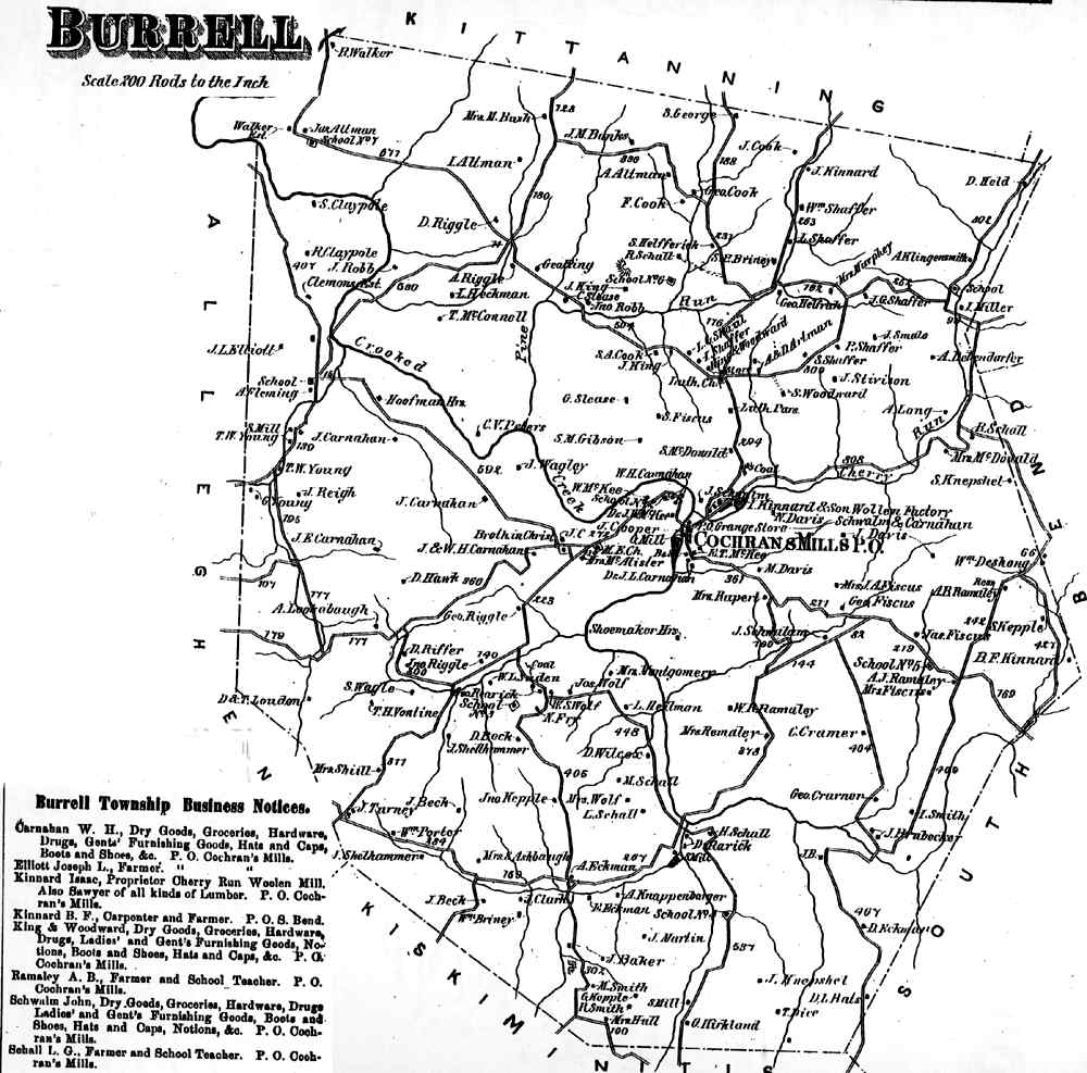
Burrell Township appears in the 1876 Atlas of Armstrong County, Pennsylvania.[8] Its early history is detailed in Robert Walter Smith's 1883 History of Armstrong County.[9]
Cemeteries[]
- Cochrans Mill United Methodist Church Cemetery[10]
- Dunkard Baptist Christian Bretheren Cemetery[11]
- McDonalds Cemetery[12]
- Saint Michaels Lutheran Church Cemetery[13]
- Shaeffer Cemetery[14]
- Shellhammer - Beck Cemetery[15]
- Shellhammer Cemetery[16]
References[]
- ^ "2016 U.S. Gazetteer Files". United States Census Bureau. Retrieved Aug 13, 2017.
- ^ a b Bureau, U. S. Census. "U.S. Census website". United States Census Bureau. US Census Bureau. Retrieved 30 November 2019.
- ^ a b "Geographic Identifiers: 2010 Demographic Profile Data (G001): Burrell township, Armstrong County, Pennsylvania". U.S. Census Bureau, American Factfinder. Archived from the original on February 12, 2020. Retrieved July 31, 2013.
- ^ "Census of Population and Housing". Census.gov. Retrieved June 4, 2016.
- ^ "U.S. Census website". United States Census Bureau. Retrieved 2008-01-31.
- ^ http://www.pittsburghclo.org/files/file/NellieBlyStudentsGuide_v4.pdf[permanent dead link]
- ^ http://explorepahistory.com/hmarker.php?markerId=1-A-3C0
- ^ "Atlas of Armstrong County Pennsylvania, page 31". Pomeroy, Whitman & Co. 1876. Retrieved 9 November 2018.
- ^ Robert Walter Smith (1883). "History of Armstrong County Pennsylvania, Chapter 16, page 364". Chicago: Waterman, Watkins. Retrieved 7 November 2018.
- ^ "Cochrans Mill United Methodist Church Cemetery". Geographic Names Information System. United States Geological Survey.
- ^ "Dunkard Baptist Christian Bretheren Cemetery". Geographic Names Information System. United States Geological Survey.
- ^ "McDonalds Cemetery". Geographic Names Information System. United States Geological Survey.
- ^ "Saint Michaels Lutheran Church Cemetery". Geographic Names Information System. United States Geological Survey.
- ^ "Shaeffer Cemetery". Geographic Names Information System. United States Geological Survey.
- ^ "Shellhammer - Beck Cemetery". Geographic Names Information System. United States Geological Survey.
- ^ "Shellhammer Cemetery". Geographic Names Information System. United States Geological Survey.
Municipalities and communities of Armstrong County, Pennsylvania, United States | ||
|---|---|---|
| City |  | |
| Boroughs | ||
| Townships | ||
| CDPs | ||
| Unincorporated communities |
| |
| ||
| Counties |  Map of the Pittsburgh Tri-State with green counties in the metropolitan area and yellow counties in the combined area | |
|---|---|---|
| Major cities | ||
| Cities and towns 15k–50k (in 2010) | ||
| Airports | ||
| Topics | ||
| ||
Coordinates: 40°40′15″N 79°26′31″W / 40.67083°N 79.44194°W

- Populated places established in 1776
- Pittsburgh metropolitan area
- Townships in Armstrong County, Pennsylvania
- Townships in Pennsylvania