Côtes-d'Armor
Côtes-d'Armor | |
|---|---|
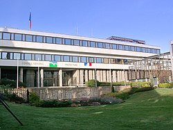 The departmental council and prefectural building in Saint-Brieuc | |
 Flag  Coat of arms | |
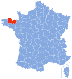 Location of Côtes-d'Armor in France | |
| Coordinates: 48°20′N 02°50′W / 48.333°N 2.833°WCoordinates: 48°20′N 02°50′W / 48.333°N 2.833°W | |
| Country | France |
| Region | Brittany |
| Prefecture | Saint-Brieuc |
| Subprefectures | Dinan Guingamp Lannion |
| Government | |
| • President of the departmental council | Alain Cadec (LR) |
| Area | |
| • Total | 6,878 km2 (2,656 sq mi) |
| Population (2016) | |
| • Total | 598,953 |
| • Rank | 43rd |
| • Density | 87/km2 (230/sq mi) |
| Time zone | UTC+1 (CET) |
| • Summer (DST) | UTC+2 (CEST) |
| Department number | 22 |
| Arrondissements | 4 |
| Cantons | 27 |
| Communes | 348 |
| ^1 French Land Register data, which exclude estuaries, and lakes, ponds, and glaciers larger than 1 km2 | |

The Côtes-d'Armor (/koʊt dɑːrmər/, /-dɑːrmɔːr/; French pronunciation: [kot daʁmɔʁ] (![]() listen); Breton: Aodoù-an-Arvor, pronounced [ˈoːdu ãn ˈarvor]), formerly known as Côtes-du-Nord (Breton: Aodoù-an-Hanternoz), are a department in the north of Brittany, in northwestern France.
listen); Breton: Aodoù-an-Arvor, pronounced [ˈoːdu ãn ˈarvor]), formerly known as Côtes-du-Nord (Breton: Aodoù-an-Hanternoz), are a department in the north of Brittany, in northwestern France.
History[]
| Year | Pop. | ±% p.a. |
|---|---|---|
| 1801 | 504,303 | — |
| 1821 | 552,424 | +0.46% |
| 1831 | 598,872 | +0.81% |
| 1841 | 607,572 | +0.14% |
| 1851 | 632,613 | +0.40% |
| 1861 | 628,676 | −0.06% |
| 1876 | 630,957 | +0.02% |
| 1881 | 627,585 | −0.11% |
| 1891 | 618,652 | −0.14% |
| 1901 | 609,349 | −0.15% |
| 1921 | 557,824 | −0.44% |
| 1936 | 532,000 | −0.32% |
| 1946 | 526,955 | −0.10% |
| 1954 | 503,178 | −0.58% |
| 1962 | 501,923 | −0.03% |
| 1968 | 506,000 | +0.13% |
| 1975 | 525,556 | +0.54% |
| 1982 | 538,860 | +0.36% |
| 1990 | 538,443 | −0.01% |
| 1999 | 542,398 | +0.08% |
| 2006 | 569,498 | +0.70% |
| 2016 | 598,953 | +0.51% |
| source:[1] | ||
Côtes-du-Nord was one of the original 83 departments created on 4 March 1790 following the French Revolution. It was made up from the near entirety of the ancient Pays de Saint-Brieuc, most of historical Trégor, the eastern half of Cornouaille, and the north-western part of the former diocese of Saint-Malo.
In 1990 the name was changed to Côtes-d'Armor: the French word côtes means "coasts" and ar mor is "the sea" in Breton. The name also recalls that of the Roman province of Armorica ("the coastal region").
Geography[]
Côtes-d'Armor is part of the current administrative region of Brittany and is bounded by the departments of Ille-et-Vilaine to the east, Morbihan to the south, and Finistère to the west, and by the English Channel to the north.
Demonym[]
The inhabitants of the department are known in French as Costarmoricains.
Politics[]
Côtes-d'Armor's long tradition of anti-clericalism, especially in the interior around Guingamp (a former Communist stronghold), has often led to the department's being seen as an area of left-wing exceptionalism in an otherwise strongly clerical and right-wing Brittany. The current president of the departmental council, Alain Cadec, is nevertheless a member of the centre-right party, Les Républicains.
| Party groupings | seats | |
|---|---|---|
| Centre et droite républicaine | 32 | |
| Socialiste et républicain | 15 | |
| Communiste et républicain | 5 | |
| non-party | 2 | |
Current National Assembly Representatives[]
Culture[]
The western part of the département is part of the traditionally Breton-speaking "Lower Brittany" (Breizh-Izel in Breton). The boundary runs from Plouha to Mûr-de-Bretagne. The Breton language has become an intense issue in many parts of Brittany, and many Breton-speakers advocate for bilingual schools. Gallo is also spoken in the east and is offered as a language in the schools and on the baccalaureat exams.
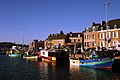
Gallery[]

Castel Meur house in Plougrescant

Statue of Bertrand du Guesclin in Dinan


Notable people[]
- Anne Beaumanoir (b. 1923), one of the Righteous Among the Nations, was born in Guildo.
- English-born poet Robert William Service (1874–1958), known as the "Bard of the Yukon", is buried in Lancieux.
See also[]
- Cantons of the Côtes-d'Armor department
- Communes of the Côtes-d'Armor department
- Arrondissements of the Côtes-d'Armor department
References[]
External links[]
| Wikimedia Commons has media related to Côtes-d'Armor. |
- (in French) Prefecture website
- (in French) General Council website
- (in English) Cotes-d'Armor at Curlie
- (in French) Tourist board website
| show Authority control |
|---|
- Côtes-d'Armor
- 1790 establishments in France
- Departments of Brittany
- States and territories established in 1790