Caloocan
Caloocan
Kalookan | |
|---|---|
Highly urbanized city | |
| City of Caloocan | |
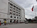      (From top, left to right: Caloocan City Hall • La Loma Cemetery • Monumento Circle • San Roque Cathedral-Parish • Caloocan Sports Complex • Caloocan Taoist Temple) | |
 Flag  Seal | |
| Motto(s): Tao ang Una | |
| Anthem: "Mabuhay ang Caloocan" | |
 Map of Metro Manila with Caloocan highlighted | |
show OpenStreetMap | |
 Caloocan Location within the Philippines | |
| Coordinates: 14°39′N 120°58′E / 14.65°N 120.97°ECoordinates: 14°39′N 120°58′E / 14.65°N 120.97°E | |
| Country | Philippines |
| Region | National Capital Region |
| Province | none |
| District | 1st to 3rd district |
| Founded | 1815 |
| Cityhood | February 16, 1962 |
| Highly urbanized city | December 22, 1979 |
| Barangays | 188 (see Barangays) |
| Government | |
| • Type | Sangguniang Panlungsod |
| • Mayor | Oscar Malapitan (NP) |
| • Vice Mayor | Luis Macario E. Asistio (NPC) |
| • Representatives |
|
| • City Council | show
Members |
| • Electorate | 719,447 voters (2019) |
| Area | |
| • Total | 55.80 km2 (21.54 sq mi) |
| Elevation | 30 m (100 ft) |
| Highest elevation | 514 m (1,686 ft) |
| Lowest elevation | −2 m (−7 ft) |
| Population (2020 census) [3] | |
| • Total | 1,661,584 |
| • Density | 30,000/km2 (77,000/sq mi) |
| • Households | 353,357 |
| Economy | |
| • Income class | 1st city income class |
| • Poverty incidence | 4.66% (2018)[4] |
| • Revenue | ₱4,384,495,437.50 (2016) |
| Service provider | |
| • Electricity | Manila Electric Company (Meralco) |
| Time zone | UTC+8 (PST) |
| ZIP code | 1400–1413, 1420–1428 |
| PSGC | |
| IDD : area code | +63 (0)02 |
| Climate type | tropical monsoon climate |
| Native languages | Tagalog |
| Website | www |


Caloocan, officially the City of Caloocan (Tagalog: Lungsod ng Caloocan; IPA: [kalɔʔokan]), is a 1st class highly urbanized city in Metropolitan Manila, Philippines. According to the 2020 census, it has a population of 1,661,584 people [3] making it the fourth-most populous city in the Philippines.
Caloocan is divided into two geographical locations with a total combined area of 5,333.40 hectares. It was formerly part of the Province of Rizal of the Philippines' Southern Luzon Region. It comprises what is known as the CAMANAVA area along with cities Malabon, Navotas and Valenzuela.
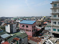
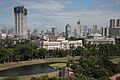
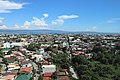
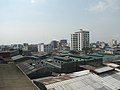
South Caloocan is bordered by Manila, Quezon City, Malabon, Navotas and Valenzuela. Presence of commercial and industrial activities combined with residential areas make it a highly urbanized central business district and a major urban center in the Northern District of Metropolitan Manila.[5] North Caloocan shares its border with Quezon City, Valenzuela and Marilao, Meycauayan and San Jose del Monte in the province of Bulacan. It is composed of mostly residential subdivisions and extensive resettlement areas with scattered distribution of industrial estates mostly within road transit points and intersections.[5]
Etymology[]
Caloocan as a toponym comes from the Tagalog root word lo-ok; kalook-lookan (or kaloob-looban) means "innermost area". The city's name is colloquially spelled as Kalookan.
There is a mixed preference over the preferred spelling of the city's name. Variation, and the apparent confusion over the spelling, came about during the early 1970s, when a resolution was adopted by the municipal board, requiring the city departments to use the name "Kalookan." The execution of the said resolution was interrupted when the country was placed under a martial law in September 1972. After the restoration of city and municipal councils, then-city councilor Aurora Asistio-Henson filed Resolution No. 006, amending the previous resolution and seeking to promote Filipino nationalism by requiring all residents and all offices and establishments in the city, "whether public or private," to spell the name of the city as "Kalookan." According to Henson, the "Filipinized spelling" provides essence and significance to the city's history, and she added that it should be used "in the city hall, the barangay halls, public markets, and other places for the information and guidance of all concerned." Nevertheless, this change in spelling was denounced by the city residents, business owners, and officials. Former legislator and mayor Virgilio Robles declared the move illegal because it lacked congressional approval. He added that the city's name is spelled as "Caloocan" as shown in the city charter. The general inclination of spelling in the city is "Caloocan" and not "Kalookan," despite the existing city ordinance, although confusion has led to varied spelling choices of many businesses throughout the city. The official logo has the city's name spelled as "Caloocan," and such spelling is favored by many barangays and public and private schools in the city. "Kalookan" is preferred by the Makati-based Directories of the Philippines Corporation (DPC), while many national newspapers and magazines, and mapmakers like the Mandaluyong-based HYDN Publishing favor "Caloocan."[6][7]
History[]

Originally, Caloocan was the area where the old town of Tondo and Tambobong met, located along the shores of Dagat-Dagatan, a crescent-shaped inland lagoon to the west. The settlement along the shore was called “Aromahan”, or “Espina” to the Spaniards, and was separated from Manila Bay by a narrow ridge from Tondo towards an opening in Kinabutasan leading to the sea.[8]
By the late 1700s, the fishermen of Aromahan has expanded towards a hill east of Dagat-Dagatan. This naturally stony hill was called “Kaloogan”, meaning “interior territory”, which evolved from the old Tagalog word “loog” (synonymous with “loob” or “inside”). The "g" sound could have shifted to the “k” sound in Tagalog phonetics (e.g. baksak > bagsak) leading to the present name of the city. With Aromahan relegated to the periphery, this hilltop area was also settled by oppressed people from Tondo, becoming the new center of the community by 1802. To the east was a vast stretch of cogon-covered land. Eventually called “Kalaanan”, meaning flat grassland in old Tagalog, this area is now generally known as Grace Park.[8]
Caloocan became a municipality when it was separated from Tondo in 1815. Its original territory extended to the foothills of Marikina, San Mateo and Montalban to the east; Tinajeros, Tanza, and Tala rivers to the north; San Francisco del Monte, Sampalok, Santa Cruz and Tondo in the south; and Dagat-dagatan and Aromahan to the west.[9] The local government building was set up on the relatively well-settled portion just above Libis Espina. The old Aromahan chapel was finally abandoned and a new church was built facing the municipal hall. To escape the Spanish authorities, many from the area abandoned the town proper and sought refuge in the grasslands of Balintawak and Pugad-Lawin, in which the people fought the landlords of Hacienda de Maysilo for terrestrial rights, which went on for almost a hundred years.[9][8]
The city is historically significant because it was the center of activities for the Katipunan, the secret militant society that launched the Philippine Revolution during the Spanish occupation of the Philippines. In a house in Caloocan, secret meetings were held by Andrés Bonifacio and his men, and it was in the city's perimeters where the first armed encounter took place between the Katipunan and the Spaniards. The revolution erupted after the “Cry of Balintawak” led by Andres Bonifacio against their oppressors on August 30, 1896.
In 1899, the people of Caloocan showed resistance to coming to terms with the Americans, who were bent on extending their supremacy over the country. The men of Caloocan fought the new invaders on February 23, 1899, however victory eluded the local troops on the pretext of Antonio Luna's rift with Aguinaldo's loyalists.[9] The city then saw heavy fighting in the Philippine–American War, at the Battle of Caloocan and the Second Battle of Caloocan.
In 1901, under the American Regime, Caloocan became one of the municipalities of the Province of Rizal. Due to the consolidation of several municipalities, Novaliches then an independent municipality, became part of then Municipality of Caloocan pursuant to Act 942, as amended by Acts 984 and 1008 of the Philippine Commission.
In 1961, after Republic Act No. 3278 was approved by the Philippine Congress and the plebiscite was conducted. Caloocan was officially inducted into cityhood on February 16, 1962.[9]
Caloocan remained a city of the Province of Rizal until November 7, 1975, when it became a part of the National Capital Region or Metro Manila, by virtue of Presidential Decree No. 824.[10]
Territorial changes[]
Caloocan once encompassed a much larger, contiguous area. The districts of Balintawak, La Loma and Novaliches were once part of Caloocan. Balintawak is a historic district because it was the original site of the "Cry of Pugad Lawin" (Unang Sigaw sa Balintawak) at a location called "Kang-kong" near Tandang Sora's house. Novaliches was an expansive sector with some hillsides that served as meeting places and hideouts for Andrés Bonifacio and the Katipunan.
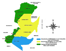
By the 1920s there was a consolidation of several municipalities. Caloocan annexed the neighbouring town of Novaliches, as stated in the Act 942, as amended by Acts 984 and 1008 of the Philippine Commission, bringing its total area to about 15,000 hectares.[9] When Commonwealth Act 502 created Quezon City in 1939, Caloocan ceded 1,500 hectares of land from the barrios or sitios of Balintawák, Balingasa, Kaingin, Kangkong, La Loma, Malamig, Matalahib, Masambong, Galas, San Isidro, San José, Santol and Tatalon. Instead of opposing the transfer, Caloocan residents willingly gave the land in the belief it will benefit the country's new capital city.[11]
However, in 1949, Congress passed Republic Act No. 392, which redefined the Caloocan-Quezon City boundary.[12] The barrios of Baesa, Talipapâ, San Bartolomé, Pasong Tamó, Novaliches poblacion, Banlat, Kabuyao, Pugad Lawin, Bagbag, Pasong Putik, which once belonged to Novaliches and had an area of about 8,100 hectares, were excised from Caloocan. The remaining portion of the Novaliches is now called North Caloocan. This split Caloocan into two parts: a southern section that is more urbanised, and a northern section that became suburban-rural.
Geography[]
Caloocan is divided into two non-contiguous areas with a total combined area of 53.334 square meters (574.08 sq ft). South Caloocan, with an area of 13.625 square meters (146.66 sq ft), is bordered on the south by Manila, on the east by Quezon City, and on the north-northwest by Malabon, Navotas and Valenzuela. North Caloocan, with an area of 39.709 square meters (427.42 sq ft), shares its border on the south-southeast by Quezon City, on the southwest by Valenzuela, and on the north by Marilao, Meycauayan and San Jose del Monte in the province of Bulacan.[9]
Topography[]

South Caloocan, where most commercial and industrial establishments are found, lies on generally flat and highly accessible land, with slopes ranging from 0-3%. The topography gradually changes into gently to moderately sloping to rolling along the North Luzon Expressway, with slopes ranging from 3-18%. The highest point at 35.00 meters above sea level can be found in this area, while the lowest point is in the southern part of Dagat-Dagatan at about 0.993 meters above mean sea level.[13]
North Caloocan is characterized with gently to steeply undulating to rolling topography with slopes ranging from 3-18%, mostly seen in the northern and central portion, gradually transforming into a southward trend of flat lands down to the southwestern tip of the boundary. Being accessible to major roads, many industrial and residential subdivisions have been developed in this near-level land.[13]
Geology[]
The geologic formation of the two portions of Caloocan varies in type and characteristics. and are specifically classified as quaternary alluvium, tuff and tuffaceous sediment, pyroclastic flow deposit, and conglomerates. The formation on the eastern half of Metropolitan Manila extending to the coastline of Manila Bay and including a greater part of South Caloocan, is the quaternary alluvium - consisting of unconsolidated stream‐deposited sediments that includes sand, silt, clay or gravel.[13]
Eastward of South Caloocan, large areas consisting of tuff and tuffaceous sediment can be traced, spreading towards the whole eastern side of Metropolitan Manila. Pyroclastic flow deposit or igneous rocks formed by the lithification of ash flow are likewise present in northern fringes of South Caloocan and in most parts of North Caloocan. On the northeast borders of North Caloocan, conglomerate rocks were traced, crossing Tala Estate and extending to the province of Bulacan and the La Mesa Watershed.[13]
Soil found in both areas of Caloocan predominantly falls under the Novaliches Series, covering 96% of the total land area of the city. The Novaliches Series is composed of reddish brown soil, friable in consistency and granular in structure. Spherical concretions are present in the subsoil and underneath are tuffaceous material of varying degrees of disintegration and weathering. Tuffaceous material is exposed by extensive erosion in some places.[13]
Surface drainages[]
Caloocan has surface waters that either have natural course (creeks and rivers) or constructed to serve as drainages to remove excess water from soil surfaces. South Caloocan has about 5.0 km length of open drainage canals that serve mainly the reclamation area comprising Kaunlaran Village (Dagat-Dagatan Development Project) and nearly 11.3 km length of natural surface water coursing through the different natural river systems. These include the Tinajeros-Tullahan River along the Caloocan-Valenzuela boundary; Maligaya Creek within La Loma Cemetery and crossing Rizal Avenue Extension; Casili Creek which terminates in Estero de Maypajo, and Cantarilla/Panaca creek along the Caloocan-Malabon boundary. In North Caloocan, all surface waters consist of natural streams, the longest being the Meycauayan-Marilao River dividing Caloocan and Bulacan. Others include the Bagong Silang River, Tala, Camarin, Pasong Malapad, and Bagumbong Creeks crossing multiple subdivisions, for 52.7 km length within the city's territorial boundaries.[13]
Climate[]
| hideClimate data for Caloocan | |||||||||||||
|---|---|---|---|---|---|---|---|---|---|---|---|---|---|
| Month | Jan | Feb | Mar | Apr | May | Jun | Jul | Aug | Sep | Oct | Nov | Dec | Year |
| Average high °C (°F) | 29 (84) |
30 (86) |
32 (90) |
34 (93) |
33 (91) |
31 (88) |
30 (86) |
29 (84) |
29 (84) |
30 (86) |
30 (86) |
29 (84) |
31 (87) |
| Average low °C (°F) | 20 (68) |
20 (68) |
21 (70) |
23 (73) |
24 (75) |
25 (77) |
24 (75) |
24 (75) |
24 (75) |
23 (73) |
22 (72) |
21 (70) |
23 (73) |
| Average precipitation mm (inches) | 7 (0.3) |
7 (0.3) |
9 (0.4) |
21 (0.8) |
101 (4.0) |
152 (6.0) |
188 (7.4) |
170 (6.7) |
159 (6.3) |
115 (4.5) |
47 (1.9) |
29 (1.1) |
1,005 (39.7) |
| Average rainy days | 3.3 | 3.5 | 11.1 | 8.1 | 18.9 | 23.5 | 26.4 | 25.5 | 24.5 | 19.6 | 10.4 | 6.4 | 181.2 |
| Source: Meteoblue [14] | |||||||||||||
Demographics[]
|
| |||||||||||||||||||||||||||||||||||||||||||||||||||
| Source: Philippine Statistics Authority [15] [16] [17][18] | ||||||||||||||||||||||||||||||||||||||||||||||||||||
As of 2020, the city has a population of 1,661,584 people, which makes it the fourth largest city in the Philippines in population. [15] Under the same census year, Caloocan South (Barangays 1 to 164) has a population of 585,091 and Caloocan North (Barangays 165 to 188) has a population of 998,887. If the two districts are treated as separate cities, they will still be among the largest in country for the 2015 census year - ranking as the 4th and 17th with the highest population.
The population density of Caloocan (28,387 persons per square kilometer) surpasses that of the NCR population density.[19]
Of the country's 238 legislative districts (LDs), the First LD of Caloocan was the biggest in terms of population size, with 1.19 million persons.[20]
Most residents speak both Filipino and English, with considerable numbers speaking other languages and dialects.
Like many other places in the country, Roman Catholicism is the predominant religion. There is a significant presence of Iglesia ni Cristo and other Protestant churches like Church of God Caloocan located at Baesa, Caloocan.
Economy[]
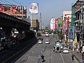
Caloocan's 10th Avenue area is well known for the clusters of motorcycle dealers and motorcycle spare parts dealers. Among the major and famous streets are P. Zamora Street and A. Mabini Street.
Numerous banks have branches in the city such as Banco de Oro, East West Bank, MetroBank, Maybank, Chinabank, Bank of the Philippine Islands, Our Lady of Grace Credit Cooperative, etc.
The city also has a number of shopping malls and stand-alone supermarkets and hypermarkets including the former Ever Gotesco Grand Central (and future SM City Grand Central), Puregold Maypajo, Monumento and Caloocan, Victory Central Mall, Puregold Monumento, Araneta Square, Uniwide Warehouse Club Monumento, SM Hypermarket Monumento, and SM Center Sangandaan which are in Monumento area in the south. In the north, there are two shopping malls serving the residents of Bagong Silang and Camarin, namely, Zabarte Town Center, Holiday Island Mall and Metroplaza Mall. Savemore Market have three branches which are located in Kiko Camarin in Barangay 178 (Kiko Camarin), Zabarte inside Zabarte Town Center, Kaybiga and Primark Deparo. Puregold Price Club also opened three branches in North Caloocan which are located in Zabarte, Bagong Silang and Deparo. In 2017, Primark Town Center Deparo started to serve the residents of Deparo and the nearby barangays of Bagumbong and Llano.
Manila North Tollways Corporation (the concession holder of the North Luzon Expressway), is headquartered in Caloocan. The North Luzon Expressway, through Segment 10.1 also traverses through Caloocan from the right-of-way of the Philippine National Railways.
Local government[]
Barangays[]


Currently, Caloocan has 188 barangays divided into 3 legislative districts.[28] District 1 is composed of 59 barangays, which include Barangays 1 to 4, 77 to 85, 132 to 164 in South Caloocan and Barangays 165 to 177 in North Caloocan. District 2 is composed of 118 barangays, which includes Barangays 5 to 76 and 86 to 131, all in South Caloocan. In addition to the city's legislative districts, District 3, which was created in 2021, includes 11 barangays in North Caloocan that was originally part of the first district, it is composed of Barangays 178 to 188.[29]
The city uses a hybrid system for its barangays, further dividing the cities into 16 Zones. Among the cities in Metro Manila, only Manila, Pasay and Caloocan implement the so-called "Zone Systems". A zone is a group of barangays in a district. Although a zone is considered a subdivision in the local government units, the people do not elect a leader for the zone in a popular election similar to the normal barangay or local elections as the system is merely for statistical purposes. Further, all barangays have their corresponding numbers but only a few — mostly in the northern part — have corresponding names. However, names of barrios and districts do not necessarily coincide with barangay perimeters. Barangays in southern Caloocan are smaller compared to their northern counterparts.
In 1989, Republic Act 6714 called for reducing the 70 barangays constituting the first congressional district of Caloocan to only thirty (30) barangays, while the 118 barangays composing the second congressional district of Caloocan were to be reduced to thirty (30) barangays. It was presumably defeated in the plebiscite that followed.[30]
Barangay Bagong Silang (176) is the most populous barangay in the country with a population of 246,515 people or 16% of the total population of Caloocan. [15] This was due to the continuous influx of informal settler families through relocation programs since the 1970s. As a result, there has been calls by residents to subdivide the Bagong Silang into seven distinct barangays [31][32]
In 1957, the sitio of Bagbaguin was separated from the barrio of Kaybiga and converted into a distinct barrio known as barrio Bagbaguin.[33]
| showCaloocan (South) |
|---|
| showCaloocan (North) |
|---|
| Designation | First district | Second district |
|---|---|---|
| Representatives | Dale Gonzalo R. Malapitan | Edgar R. Erice |
| Mayor | Oscar G. Malapitan | |
| Vice Mayor | Luis Macario E. Asistio III | |
| Councilors | Vincent Ryan R. Malapitan | Edgardo N. Aruelo |
| Anna Karina T. Limsico | Luis Asistio III | |
| Dean Asistio | Roberto R. Samson | |
| Christopher E. Malonzo | Alexander V. Mangasar | |
| Carmelo F. Africa III | Ma. Milagros S. Mercado | |
| Marylou Nubla | Ricardo J. Bagus | |
| ABC President | Jose Lorenzo T. Almeda | |
| SK President | Orvince Howard A. Hernandez | |
List of Mayors and Vice Mayors[]
| Municipality of Caloocan, Province of Rizal | ||
|---|---|---|
| Period of tenure | Mayor | Vice Mayor |
| 1902–1904 | Pedro Sevilla | |
| 1904–1906 | Silverio Baltazar | |
| 1906–1908 | Tomas Susano | |
| 1908–1910 | Leon Nadurata | |
| 1910–1913 | Emilio Sanchez | |
| 1913–1915 | Godofredo Herrera | |
| 1915–1921 | Jose Sanchez | |
| 1922–1925 | Dominador Aquino | |
| 1926–1928 | Pablo Pablo | |
| 1928–1931 | Dominador Aquino | |
| 1932–1940 | Pablo Pablo | |
| 1941–1944 | Cornelio Cordero | |
| 1945–1946 | Oscar Baello | |
| 1946–1951 | Jesus Basa | Anacleto Bustamante (1950–1954) |
| 1952–1962 | Macario Asistio Sr | Mateo Lualhati (1962–1963) |
| City of Caloocan, Province of Rizal | ||
| 1962–1971 | Macario Asistio Sr. | Alejandro Fider (1964–1971) |
| 1972–1976 | Marcial Samson | Isagani Arcadio |
| City of Caloocan, Metropolitan Manila | ||
| 1976–1978 | Alejandro Fider | |
| 1978–1980 | Virgilio Robles | |
| 1980–1986 | Macario Asistio Jr. | Macario "Mac" Floro Ramirez Sr. |
| 1986 | Virgilio Robles | Vicente Del Mundo |
| 1986–1987 | Antonio Martinez | Vicente del Mundo |
| 1987–1988 | Crisipulo San Gabriel | Lina Aurelio |
| 1988–1995 | Macario Asistio Jr. | Celestino Rosca |
| 1995–1998 | Rey Malonzo | Nancy Quimpo |
| 1998–2001 | Oscar Malapitan | |
| 2001–2004 | Luis Varela | |
| 2004–2010 | Enrico Echiverri | |
| 2010–2013 | Edgar Erice | |
| 2013–2022 | Oscar Malapitan | Macario Asistio III |
Infrastructure[]
Transportation[]

The LRT Line 1 has two stations in the city, namely: Monumento and 5th Avenue. The railway traverses Rizal Avenue Extension and enters the City of Manila and Pasay, as well as Quezon City. The stretch can be traveled in about 30 minutes. Philippine National Railways also has a line, with its terminal at Samson Road, and passes through Caloocan railway station, 10th Avenue railway station, and 5th Avenue railway station. The currently under construction MRT Line 7 had also proposed two stations located at the northern part of Caloocan that will be passing at Sacred Heart and Tala.
The city has an extensive network of roads, the most prominent being Epifanio de los Santos Avenue, which begins in the Monumento area. Quirino Highway, which connects Quezon City and eastern Bulacan, also traverses the northern part of Caloocan. The North Luzon Expressway's Operations and Maintenance Center and the motorway's Balintawak Toll Barrier are in Caloocan. Its extension in the NLEX Harbor Link that connects it towards Navotas and Port of Manila also traverses Caloocan. The NLEX Connector project that will connect Harbor Link with the City of Manila and Skyway is currently under construction. The northern end of Skyway, which connects the North and South Luzon Expressways, is also found near NLEX's Balintawak toll plaza, with a possible connection to a future toll road leading to the New Manila International Airport.
Bus line Victory Liner Incorporated has its headquarters and terminal along in Rizal Avenue Extension near the Monumento station.
Landmarks[]

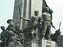
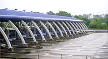
The city's most celebrated landmark is the monument to the revolutionary Andrés Bonifacio, which stands on a roundabout where EDSA, MacArthur Highway, Samson Road, and Rizal Avenue Extension intersect. The memorial was erected in 1933, and consists of an obelisk with sculptures by National Artist Guillermo Tolentino. The monument marks the very first battle of the Philippine Revolution on 3 August 1896. Recent renovations have been made on the environs of the monument, including the Bonifacio Circle, its former site, and the Caloocan stretch of EDSA, which is 100 metres away from the landmark. The whole area is known as 'Monumento'.
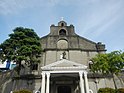
The new Caloocan City Hall stands in a rectangular lot bordered by 8th and 9th Streets and 8th and 9th Avenues in the southern part of the city. The old Caloocan City Hall stands at A. Mabini Street in the southern part across from San Roque Parish Cathedral, the first parish church in Caloocan where meetings of the Katipunan took place.[37] There is also the Caloocan City Hall North serving the northern part of the city, located along Zapote Street in Camarin. The city's District Office of the Bureau of Internal Revenue is along EDSA.
Other sites of historical importance identified by the city government include a lot in P. Zamora Street where the wife of Katipunan leader Andres Bonifacio once resided; the heritage house of Gertrudes Sevilla, the owner of which is the nephew of Gregoria De Jesus,;[38][37] Santa Quiteria Church in Baesa; and Our Lady of Grace Parish in 11th Avenue; La Loma Cemetery]], the oldest cemetery in Manila; and Thai To Taoist Temple along 6th Avenue.
Police[]
The Caloocan City Police Station is under the parent agency National Capital Region Police Office's Northern Police District of the Philippine National Police.
The whole Caloocan city police force was recently sacked after a series of crimes, including killings and robberies, were committed by its members. However, instead of dismissing the erring police officers, they were scheduled to be retrained by then-PNP Chief Ronald dela Rosa.
Education[]
The city's one public university is the University of Caloocan City (formerly Caloocan City Community College in 1971 and Caloocan City Polytechnic College in 1975). Other educational institutions offering tertiary education include University of the East Caloocan, Manila Central University, La Consolacion College-Caloocan, and La Consolacion College-Novaliches, among others.
There are also several public and private schools catering to K12 such as:
- Caloocan National Science and Technology High School (North Caloocan's first-ever science and technology high school; its students are admitted if they pass a competitive examination)
- Caloocan City Science High School
- Caloocan City Business High School
- Caloocan High School
- Amparo High School
- Maria Clara High School
- Philippine Cultural College (Annex)
- Holy Infant Montessori Center
- Northern Rizal Yorklin School
- St. Mary's Academy of Caloocan City
- Bagumbong High School
- Antonio Luna High School (formerly Bagumbong High School-Annex)
- Camarin High School
- Tala High School
- Manuel Luis Quezon High School
- Sampaguita High School
- Cielito Zamora High School
- Bagong Silang High School
- National Housing Corporation High School (NHC HS)
- Genesis Christian Academy of Caloocan
- Kalayaan National High School
- Deparo High School
- Escuela de Sophia of Caloocan, Inc.
- Escuela San Gabriel de Arcangel Foundation, Inc.
- Colegio de San Gabriel of Caloocan, Inc.
- Guardian Angel School
- Horacio Dela Costa Elementary School
- Horacio Dela Costa High School
- Antonio Uy Tan Senior High School
- Saint Benedict School of Novaliches
- Saint Dominic Savio School of Caloocan City
- Saint Andrew School MHANLE Inc.
- Immaculada Concepcion College
- Systems Plus Computer College
- St. Gabriel Academy
- Asian Institute of Computer Studies – Caloocan
- St. Clare College of Caloocan
- Mystical Rose School of Caloocan, Inc.
- Holy Angel School of Caloocan, Inc.
- St. Agnes Academy of Caloocan, Inc.
- St. Therese of Rose School,
- Young Achievers School of Caloocan
- St. Joseph College of Novaliches
- St. Raphaela Mary School of Caloocan
- Our Lady of Lourdes Catholic School
- Maranatha Christian Academy of Caloocan (Camarin)
- Kasarinlan High School
- Kasarinlan Elementary School
- Grace Park Elementary School
- Maypajo Elementary School
- Sampalukan Elementary School
- Libis Talisay Elementary School
- Kaunlaran Elementary School
- Lerma Elementary School
- Pag-Asa Elementary School
- Camarin Elementary School
- La Consolacion College
- Caloocan (South) Campus
- Novaliches (Deparo) Campus
There is a campus of Access Computer College, AMA Computer College Campus, a degree-awarding tertiary educational institution and STI Academic Center Caloocan at the Samson Road Road corner Caimito Road in front of UE Caloocan.
Twin towns – sister cities[]
Local[]
- Calamba, Laguna
- Malabon, Metro Manila
- San Jose del Monte, Bulacan
International[]
 Incheon, South Korea[39]
Gallery[]

San Roque Cathedral-Parish in Poblacion district

Old St. Pancratius Chapel in La Loma Cemetery

Caloocan City Hall North
View of Barangay 15 and 16 from the old city hall

Regional Trial Courts, Halls of Justice

Vicariate of Our Lady of Grace, Diocesan Shrine of Our Lady of Grace, Roman Catholic Diocese of Kalookan


References[]
- ^ City of Caloocan | (DILG)
- ^ "2015 Census of Population, Report No. 3 – Population, Land Area, and Population Density" (PDF). Philippine Statistics Authority. Quezon City, Philippines. August 2016. ISSN 0117-1453. Archived (PDF) from the original on May 25, 2021. Retrieved July 16, 2021.
- ^ Jump up to: a b Census of Population (2020). "National Capital Region (NCR)". Total Population by Province, City, Municipality and Barangay. PSA. Retrieved 8 July 2021.
- ^ https://psa.gov.ph/sites/default/files/Table%202a.%20Updated%20Annual%20Per%20Capita%20Poverty%20Threshold%2C%20Poverty%20Incidence%20and%20Magnitude%20of%20Poor%20Population%20with%20Measures%20of%20Precision%2C%20%20by%20Region%2C%20Province%20and%20HUC_2018.xlsx; publication date: 4 June 2020; publisher: Philippine Statistics Authority.
- ^ Jump up to: a b "Comprehensive Land Use Plan Report, City of Caloocan (1995-2020) - Free Download PDF". kupdf.net.
- ^ "Confusion over spelling: Caloocan or Kalookan?". The Manila Times. October 19, 2004. Retrieved April 2, 2020.
- ^ Samonte, Severino (December 6, 2018). "Which is which, Caloocan or Kalookan?". Philippine News Agency. Retrieved April 2, 2020.
- ^ Jump up to: a b c Joaquin, Agapito. "The Role of Kalookan in the Nation's Quest for Freedom". Retrieved 26 April 2020.
- ^ Jump up to: a b c d e f "History2". caloocancity.gov.ph.[permanent dead link]
- ^ "Presidential Decree No. 824 November 7, 1975. Creating the Metropolitan Manila and the Metropolitan Manila Commission and for Other Purposes". lawphil.net. Arellano Law Foundation. November 7, 1975. Archived from the original on March 12, 2016. Retrieved July 10, 2020.
- ^ "Commonwealth Act No. 502". www.officialgazette.gov.ph. Retrieved 2020-07-11.
- ^ Juris, The Corpus (June 18, 1949). "R.A. No. 392: An Act to Amend §3 of C.A. No. 502, as Amended, Redefining the Boundaries of Quezon City". The Corpus Juris.
- ^ Jump up to: a b c d e f "Climate change action plan" (PDF). caloocancity.gov.ph. 2016. Archived from the original (PDF) on 2019-07-17. Retrieved 2020-07-11.
- ^ "Caloocan: Average Temperatures and Rainfall". Meteoblue. Retrieved 13 May 2020.
- ^ Jump up to: a b c Census of Population (2015). "National Capital Region (NCR)". Total Population by Province, City, Municipality and Barangay. PSA. Retrieved 20 June 2016.
- ^ Census of Population and Housing (2010). "National Capital Region (NCR)". Total Population by Province, City, Municipality and Barangay. NSO. Retrieved 29 June 2016.
- ^ Censuses of Population (1903–2007). "National Capital Region (NCR)". Table 1. Population Enumerated in Various Censuses by Province/Highly Urbanized City: 1903 to 2007. NSO.
- ^ "Province of Metro Manila, 3rd (Not a Province)". Municipality Population Data. Local Water Utilities Administration Research Division. Retrieved 17 December 2016.
- ^ "Philippine Population Density (Based on the 2015 Census of Population)". Philippine Statistics Authority. Retrieved 6 December 2016.
- ^ "Population Counts by Legislative District (Based on the 2015 Census of Population)". Philippine Statistics Authority. Retrieved 6 December 2016.
- ^ "Poverty incidence (PI):". Philippine Statistics Authority. Retrieved 28 December 2020.
- ^ https://psa.gov.ph/sites/default/files/NSCB_LocalPovertyPhilippines_0.pdf; publication date: 29 November 2005; publisher: Philippine Statistics Authority.
- ^ https://psa.gov.ph/sites/default/files/2003%20SAE%20of%20poverty%20%28Full%20Report%29_1.pdf; publication date: 23 March 2009; publisher: Philippine Statistics Authority.
- ^ https://psa.gov.ph/sites/default/files/2006%20and%202009%20City%20and%20Municipal%20Level%20Poverty%20Estimates_0_1.pdf; publication date: 3 August 2012; publisher: Philippine Statistics Authority.
- ^ https://psa.gov.ph/sites/default/files/2012%20Municipal%20and%20City%20Level%20Poverty%20Estima7tes%20Publication%20%281%29.pdf; publication date: 31 May 2016; publisher: Philippine Statistics Authority.
- ^ https://psa.gov.ph/sites/default/files/City%20and%20Municipal-level%20Small%20Area%20Poverty%20Estimates_%202009%2C%202012%20and%202015_0.xlsx; publication date: 10 July 2019; publisher: Philippine Statistics Authority.
- ^ https://psa.gov.ph/sites/default/files/Table%202a.%20Updated%20Annual%20Per%20Capita%20Poverty%20Threshold%2C%20Poverty%20Incidence%20and%20Magnitude%20of%20Poor%20Population%20with%20Measures%20of%20Precision%2C%20%20by%20Region%2C%20Province%20and%20HUC_2018.xlsx; publication date: 4 June 2020; publisher: Philippine Statistics Authority.
- ^ "Duterte splits Caloocan into 3 districts".
- ^ https://www.officialgazette.gov.ph/downloads/2021/05may/20210523-RA-11545-RRD.pdf
- ^ "REPUBLIC ACT NO. 6714 AN ACT MERGING, DIVIDING, AND/OR REVIVING THE DIFFERENT BARANGAYS IN CALOOCAN CITY AND FOR OTHER PURPOSES". Official Gazette of the Republic of the Philippines. February 28, 1989. Retrieved July 26, 2019.
- ^ Bajo, Ramil; Galupo, Rey (September 17, 2013). "Mayor supports move to split Caloocan barangay into seven". The Philippine Star. Retrieved 29 April 2020.
- ^ "House Bill No. 5410" (PDF). Archived from the original (PDF) on 2019-05-13. Retrieved 2020-04-29.
- ^ "An Act to Convert the Sitio of Bagbaguin, Municipality of Caloocan, Province of Rizal, into a Barrio to be known as Barrio Bagbaguin of the Same Municipality and Separating it from the Barrio of Caybiga of the Same Municipality". LawPH.com. Retrieved 2011-04-12.
- ^ Jump up to: a b c "Home". caloocancity.gov.ph.
- ^ Jump up to: a b "Local shelter plan" (PDF). www.caloocancity.gov.ph. Retrieved 2020-07-11.
- ^ "mayors-of-caloocan List of Mayors and Vice Mayors of Caloocan".
- ^ Jump up to: a b "CALOOCAN CITY MEDIUM TERM". yumpu.com.
- ^ Cayabyab, Marc Jayson (June 16, 2019). "Caloocan elderly remember Bonifacio's wife". The Philippine Star. Retrieved 30 April 2020.
- ^ "Sister cities". Manila Bulletin. Retrieved 30 August 2016.
External links[]
| Wikivoyage has a travel guide for Caloocan. |
| Wikimedia Commons has media related to Caloocan. |
- Official website
- Philippine Standard Geographic Code
- History of Caloocan, Philippines
 Geographic data related to Caloocan at OpenStreetMap
| show Jurisdictions adjacent to Caloocan |
|---|


| show Authority control |
|---|
- Caloocan
- Cities in Metro Manila
- Populated places established in 1815
- 1815 establishments in the Philippines
- Highly urbanized cities in the Philippines