Transportation in Metro Manila


The transportation system in Metro Manila is currently inadequate to accommodate the mobility and other basic needs of a densely populated metropolis, the result of many factors and problems that the government has failed to provide or address. Metro Manila exists in a state of near-permanent gridlock, with people and goods trapped by the very system that is supposed to move them quickly and efficiently.[1] Car ownership has also risen dramatically, both because of the insufficient public transportation network and of cars being viewed as status symbols.[2] In recent years, however, the Philippine government has been pushing to improve the mass transit system through various infrastructure projects,[3] hoping to solve the interlinked problems of transportation, land use and environment.[4]
Transport management in the region is decentralized, with the Department of Transportation (DOTr), the Department of Public Works and Highways (DPWH), and the Metropolitan Manila Development Authority (MMDA) all responsible for managing the system in the region.
Metro Manila offers various modes of transportation. These include the popular jeepney, which has been in use since the years immediately after World War II, buses, tricycles (auto rickshaws) and pedicabs. In some areas, especially in Divisoria and large public markets, two-stroke motors are fitted in the pedicabs and are used for goods transport. Regardless of modernity, horse-drawn kalesas are still used in the streets of Binondo and Intramuros. Grab, a ridesharing service, also operates in Metro Manila.[5]
Railways were once the dominant mode of transportation in Metro Manila, with both the Philippine National Railways (PNR) and Tranvía systems serving numerous parts of the region. However, these systems declined due to various factors and road-based transportation replaced them.[6] Rail transit was then introduced in 1984 with the LRT Line 1 and would soon be followed by LRT Line 2 and MRT Line 3. The PNR Metro Commuter Line, a commuter rail service connecting Metro Manila to the adjacent province of Laguna, have been operating since 1970. More train lines such as the Metro Manila Subway are planned or under construction.[7]
Infrastructure[]

Roads[]
The existing main roads of Metro Manila are organized around a set of Radial and Circumferential roads established during the American period in the country's history. All radial roads originate from various points in the city of Manila and radiate south, east or north to the other cities in Metro Manila and end farther out into the Greater Manila Area and beyond. In a similar way, all circumferential roads run in a half circle that begins and ends at Manila Bay, with Manila at the innermost circle.
The only major thoroughfare in Metro Manila not included in the arterial road system is Dr. Arcadio Santos Avenue (formerly Sucat Road) in Parañaque, designated as Highway N63
Expressways[]


Expressways are controlled-access highways, with crossing traffic limited to overpasses, underpasses, and interchanges. Metro Manila is served by the North Luzon Expressway to the north and South Luzon Expressway to the south. Connecting the two is the Skyway, an elevated expressway that runs through the metropolis by going above the existing alignment of major thoroughfares in the region. Other expressways include the Muntinlupa–Cavite Expressway and the NAIA Expressway, with other expressways such as the Southeast Metro Manila Expressway,[8] C-5 Southlink Expressway, C-5 Expressway, Pasig River Expressway, and the R-7 Expressway all in various stages of development and construction.
Bridges[]
There are a total of 33 bridge spans in Metro Manila that cross the Pasig and Marikina rivers, including one tollway bridge and four railway bridges.
Public transportation[]
Buses[]
Bus services in Metro Manila are regulated by the Department of Transportation (DOTr) and the Metropolitan Manila Development Authority (MMDA) and operated by private bus operators.[9]
Before the rationalization program, the region had more than 900 public transport routes operated by 830 bus franchises and more than 43,000 jeepney franchises competing with each other.[10] This extremely deregulated public transport environment has made managing public transport services a challenge for the government for many years. The oversupply of public utility vehicles as well as redundant and overlapping transport routes have also led to severe road congestions.[10] This meant that buses were the bane of Metro Manila's congested roads due to their numbers, their sheer physical size, and the methods of bus drivers and conductors of loading and unloading passengers.
In response, the national government instituted various reforms. By 2019, the MMDA ordered the removal of all provincial bus terminals along EDSA.[11] In June 2020, the DOTr launched the Metro Manila Bus Rationalization Program, completely overhauling Manila's bus transport network. The program was a follow through of the 2017 Public Utility Vehicle Modernization Program and coincided with the government's gradual and calibrated resumption of Manila's public transport following more than two months under coronavirus restrictions.[12][13] There are 35 rationalized bus routes currently operating in the Greater Manila Area.[14][15]
In addition to the regular bus routes, there are three franchised city buses. These are BGC Bus, Citylink Coach Services, and HM Transport.
Bus rapid transit[]
A planned introduction to the metropolis is the bus rapid transit system (BRT), which makes use of a dedicated lane, buses with large traffic volume, suitable stations and employs an intelligent transportation system. Several BRT lines have been discussed and proposed, all are pending approval.
The EDSA Carousel line, which starts from Monumento in Caloocan and ends at Parañaque Integrated Terminal Exchange (PITX), contains elements of a BRT system. However, the DOTr has stated that the busway is distinct from the World Bank-funded EDSA BRT.[17]
Point-to-point buses (express buses)[]
Express point-to-point buses provide non-stop or limited stop travel along Metro Manila. As of 2019, there are 52 points in the Greater Manila Area served by P2P buses.[18] Majority of the routes are served by single decker buses with just two served by double deckers.
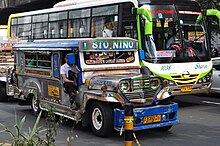
Jeepneys[]

Jeepneys are the most popular mode of public transportation in the Philippines and have also become a ubiquitous symbol of the Philippine culture.[19] According to the Metro Manila Dream Plan report by the Japan International Cooperation Agency (JICA), a survey made in 2007 came out with 48,366 public utility jeepneys plying some 600 routes nationwide, with 61% serving the Greater Capital Region, which includes Metro Manila. In 2000, jeepneys and tricycles topped all modes of travel in Metro Manila at 46%, before light rail became popular, followed by buses at 24% and private vehicles at 21%.[20] At present, there are around 270,000 franchised jeepney units on the road across the country, with some 75,000 units in Metro Manila alone.[21]
In 2016, the DOTr imposed an age limit on jeepneys of 15 years, with older jeepneys starting to be phased out.[22] The Public Utility Vehicle Modernization Program was formally launched in 2017, beginning the gradual phaseout of old jeepneys. As part of the PUV modernization program, all new and existing vehicles must be fitted with a tap card system which allows commuters to pay for their trip.[23] The system would enable journey details to be recorded and the appropriate fare deducted from the stored value on the card.[24] The majority of jeepney operators have voiced support,[25] with a few groups voicing their opposition.[26] Some politicians have urged the government to drop the jeepney modernization program.[27] A 2019 study also showed that a majority of commuters prefer to ride an e-jeepney than a conventional jeepney in areas where it is available, as it provides a safer, environment-friendly, and more comfortable ride.[28]
Rail transportation[]


Rail transportation in the Greater Manila Area is a major part of the transportation system in Metro Manila and its surrounding areas. It consists of the Manila Light Rail Transit System, Manila Metro Rail Transit System, and the PNR Metro Commuter Line. The network makes up the majority of active railways in the country and bear the brunt of providing the metropolis with rail as a faster alternative mode of transport other than buses and jeepneys. However, these systems are currently insufficient for the rapidly expanding metropolis; to address this, new lines and line extensions are under construction, which will extend the system far out into neighboring regions.[7]
While early rail systems have been operating in the region since 1883, the development of mass transit had its inception in the 1970 when the Philippine National Railways offered among its services the first Metro Commuter line. LRT Line 1, which is the first rail line operated by the Light Rail Transit Authority, a government corporation, opened in 1984, making it the first rapid rail transport in Southeast Asia. It was followed in 1999 by MRT Line 3 along EDSA operated by the private company, Metro Rail Transit Corporation, before LRT Line 2 was completed in 2003.
Intermodal terminals[]
| Name | Location | Transfers | Notes | |
|---|---|---|---|---|
| Rail | Other modes | |||
| Araneta City Bus Port (ACBP) | Quezon City | Bus, jeepney, taxi and UV Express | Opened on March 14, 2017.[29] | |
| Parañaque Integrated Terminal Exchange (PITX) | Parañaque | Bus, jeepney, taxi and UV Express | Opened on November 5, 2018. | |
| North Triangle Common Station | Quezon City | 3 MRT Line 3 7 MRT Line 7 MMS Metro Manila Subway |
To be announced | Area B completed, Areas A and C under construction. |
| Taguig Integrated Terminal Exchange (TITX) | Taguig | MMS Metro Manila Subway and NSCR North–South Commuter Railway via FTI |
Bus, jeepney, taxi, and UV Express |
Under construction |
| Valenzuela Gateway Complex (VGC) | Valenzuela | — | Tricycles, buses, jeepneys and UV Express | Opened on August 15, 2018.[30] |
| Note: Terminals and lines in italics are under construction | ||||
Air transportation[]
Airports[]

The Ninoy Aquino International Airport (IATA: MNL, ICAO: RPLL), is the main international gateway to the Philippines and Metro Manila. The airport is located between Pasay and Parañaque, about seven kilometers south of Manila city proper and southwest of Makati. It is managed by the Manila International Airport Authority (MIAA), an attached agency of the Department of Transportation (DOTr).[31]
With a record-breaking 42-million people using the airport in 2017, NAIA has long breached the 30-million combined passenger capacity of its four terminals.[32] While numerous proposals from the private sector to expand NAIA have been put forward, none have been implemented.[32][33][34] There are also exploratory talks to transfer terminal assignments among airlines.[35]
Officially, NAIA is the only airport serving the Manila area. However, in practice, both NAIA and Clark International Airport, located in the Clark Freeport Zone in Pampanga, serve the Manila area, with Clark catering mostly to low-cost carriers because of its lower landing fees compared to those charged at NAIA. In 2018, Clark handled 2.6 million passengers, all the while undergoing expansion to bring capacity to 12 million with the addition of a second terminal to be finished by 2021.[36][37]
Proposed airports[]
In June 2014, JICA formally recommended the construction of a new airport in the vicinity of Sangley Point, Cavite City to replace the space-constricted NAIA. The recommendation involved the reclamation of Manila Bay to locate the new airport. This is contained in JICA's Metro Manila Dream Plan roadmap.
San Miguel Corporation, builders and concessionaires of the Manila Skyway and other infrastructure projects, submitted another unsolicited proposal in April 2018 to build an airport in northeast Manila Bay. In July 2019, the Swiss challenge period ended with no rival bids, and in September 2019 was given the Notice to Proceed from the Department of Transportation to build, operate and maintain the New Manila International Airport.[38] Pre-construction activities, including dredging of the rivers and canals leading to the site, began in October 2020. The first phase, consisting of two runways and the terminal buildings, is scheduled for completion by 2026.[39]
Water transportation[]
Seaports and piers[]

The Port of Manila, located in the vicinity of Manila Bay, is the chief seaport of the Philippines. It primarily serves the city's commercial needs. North Harbor and South Harbor experience busy periods during long holidays such as Holy Week, All Saints Day and the Christmas holidays.
Pasig River Ferry[]
The Pasig River Ferry Service operates 17 stations along the Pasig River from Plaza Mexico in Intramuros to Pasig. The ferry service is the only water-based transportation that cruises the Pasig River.
See also[]
- List of rail transit stations in the Greater Manila Area
- Traffic in Metro Manila
- Public Utility Vehicle Modernization Program
- Transportation in the Philippines
- Department of Public Works and Highways
- Department of Transportation
- Philippine highway network
- Philippine Nautical Highway System
References[]
- ^ "Dear President-elect Duterte: On solving the traffic crisis". 31 May 2016.
- ^ "Love of cars and hatred of traffic". archives.bworldonline.com. Retrieved 2021-07-14.
{{cite web}}: CS1 maint: url-status (link) - ^ "Government keen on improving public transport system". Philstar. Retrieved 2013-01-30.
- ^ https://www.jica.go.jp/topics/news/2014/ku57pq00001nkatn-att/20140917_01_0rev20150206.pdf[dead link]
- ^ "Why GrabTaxi?". Grab.
- ^ Satre, Gary L. (June 1998). "The Metro Manila LRT System—A Historical Perspective" (PDF). Japan Railway and Transport Review. 16: 33–37. Archived from the original (PDF) on May 5, 2006. Retrieved May 8, 2006.
- ^ a b Times, The Manila (2021-03-09). "Praiseworthy progress in commuter rail infrastructure". The Manila Times. Retrieved 2021-07-13.
- ^ "DOTr break ground on South East Metro Manila Expressway project". CNN Philippines. January 8, 2018. Retrieved January 18, 2018.
- ^ "Memorandum Circular No. 2020-019". Land Transportation Franchising and Regulatory Board. May 24, 2020. Retrieved September 10, 2020.
- ^ a b Mettke, C.; Guillen, D.; Villaraza, C. (2016). "Transforming Public Transport in the Philippines" (PDF). Changing Transport. Department of Transportation (Philippines). Retrieved September 13, 2020.
- ^ "MMDA eyes total ban on provincial bus terminals along EDSA by January".
- ^ dela Cruz, R.C. (June 4, 2020). "DOTr announces launch of 6 new bus routes in Metro Manila". Philippine News Agency. Retrieved September 10, 2020.
- ^ San Juan, A. (June 24, 2020). "31 rationalized city bus routes now open — LTFRB". Manila Bulletin. Retrieved September 10, 2020.
- ^ Marquez, C. (June 24, 2020). "All 31 city bus routes in Metro Manila now open — LTFRB". Philippine Daily Inquirer. Retrieved September 10, 2020.
- ^ "Memorandum Circular No. 2020-038" (PDF). Land Transportation Franchising and Regulatory Board. August 17, 2020. Retrieved November 18, 2020.
- ^ https://ppp.gov.ph/ppp_projects/bonifacio-global-city-brt/[dead link]
- ^ a b c "San Miguel plans bus rapid transit on Skyway 3". Rappler. 26 April 2021. Retrieved 3 May 2021.
- ^ https://p2pbus.ph/
- ^ Lema, Karen (2007-11-20). "Manila's jeepney pioneer fears the end of the road". Reuters. Retrieved 2008-02-27.
- ^ http://www.diva-portal.org/smash/get/diva2:22252/FULLTEXT01.pdf
- ^ Agaton, Casper Boongaling; Guno, Charmaine Samala; Villanueva, Resy Ordona; Villanueva, Riza Ordona (2019). "Diesel or Electric Jeepney? A Case Study of Transport Investment in the Philippines Using the Real Options Approach". World Electric Vehicle Journal. 10 (3): 51. doi:10.3390/wevj10030051.
- ^ Periabras, Rosalie C. (5 August 2015). "DOTC, PUJ operators tackle jeepney modernization". The Manila Times. Retrieved 26 April 2016.
- ^ "Can a 'tap card' payment system convince you to take jeepneys again?". Top Gear Philippines. Retrieved 17 April 2018.
- ^ PH, Carmudi. "DOTr launches PUV Modernization Expo". Yahoo News.
- ^ "24 AGENCIES, 20 TRANSPORT GROUPS AND COOPERATIVES PUSH FOR PUV MODERNIZATION". Department of Transportation. Retrieved April 14, 2018.
- ^ Badilla, Nielson S. (31 January 2016). "Groups to protest jeepney phaseout". The Manila Times. Retrieved 26 April 2016.
- ^ De Vera, Ellalyn (17 April 2016). "LTFRB urged to shelve planned phaseout of traditional jeepneys". Manila Bulletin. Retrieved 26 April 2016.
- ^ Agaton, Casper Boongaling; Collera, Angelie Azcuna; Guno, Charmaine Samala (2020). "Socio-Economic and Environmental Analyses of Sustainable Public Transport in the Philippines". Sustainability. 12 (11): 4720. doi:10.3390/su12114720.
- ^ de Jesus, J.L. (March 14, 2017). "Bus rider Robredo graces launch of modern Cubao terminal". Philippine Daily Inquirer. Retrieved July 14, 2020.
{{cite web}}: CS1 maint: url-status (link) - ^ Pateña, Aerol John (August 6, 2018). "Provincial buses may use Valenzuela terminal starting Aug. 15: MMDA". Philippine News Agency. Retrieved March 28, 2018.
- ^ "Creating the Manila International Airport Authority, Transferring Existing Assets of the Manila International Airport to the Authority, and Vesting the Authority with Power to Administer and Operate the Manila International Airport". Official Gazette of the Republic of the Philippines. Republic of the Philippines. Retrieved October 24, 2013.
- ^ a b Mateo, Jan Victor R. "Uncertain future: What's next for NAIA?". Philstar.com. Retrieved 2021-07-13.
- ^ Lopez, Melissa Luz. "Megawide GMR replaces NAIA Consortium in airport rehab project". CNN Philippines. Retrieved July 17, 2020.
- ^ Cabuenas, Jon Viktor D. (January 26, 2021). "Megawide officially loses NAIA rehab bid". GMA News Online. Retrieved June 3, 2021.
- ^ "No changes in NAIA terminal assignments for airlines by Aug. 31". 30 July 2018.
- ^ Rey, Aika (October 13, 2020). "Construction of new Clark airport terminal completed". Rappler. Retrieved March 31, 2021.
- ^ Navales, Reynaldo G. (March 19, 2021). "New Clark airport terminal inauguration set on June 11". SunStar. Retrieved March 31, 2021.
- ^ Lopez, Melissa Luz (18 September 2019). "Bulacan airport deal signed, construction to start December". CNN Philippines. Retrieved 18 September 2019.
- ^ Gonzales, Iris (October 7, 2020). "SMC to start construction of Bulacan airport". The Philippine Star. Retrieved October 8, 2020.
City of Manila | ||
|---|---|---|
| Topics |
|  |
| Government |
| |
| Districts |
| |
| Mixed-use developments |
| |
| Beaches | ||
| Legislative districts |
| |
| ||
- Transportation in Metro Manila
- Transportation in Luzon