Pateros
This article needs additional citations for verification. (April 2018) |
Pateros | |
|---|---|
| Municipality of Pateros | |
 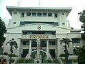 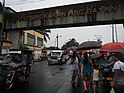 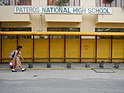  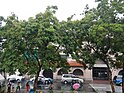 (From top, left to right : Pateros Church • Pateros Municipal Hall • Makati-Pateros boundary • Pateros National High School • Pateros Downtown area • Town Plaza and De Borja Park) | |
 Flag  Seal | |
| Nickname(s): Balut Capital of the Philippines;
Small Town with a Big Heart | |
| Motto(s): Isang Pateros English: One Pateros | |
| Anthem: Imno ng Pateros English: Pateros Hymn | |
 Map of Metro Manila with Pateros highlighted | |
show OpenStreetMap | |
 Pateros Location within the Philippines | |
| Coordinates: 14°32′30″N 121°04′00″E / 14.5417°N 121.0667°ECoordinates: 14°32′30″N 121°04′00″E / 14.5417°N 121.0667°E | |
| Country | Philippines |
| Region | National Capital Region |
| District | Lone district, shared with Taguig |
| Founded | 1770 |
| Chartered | March 29, 1909 |
| Barangays | 10 (see Barangays) |
| Government | |
| • Type | Sangguniang Bayan |
| • Mayor | Miguel "Ike" F. Ponce III |
| • Vice Mayor | Gerald S. German |
| • Representative | Alan Peter S. Cayetano |
| • Council | show
Members |
| • Electorate | 37,235 voters (2019) |
| Area | |
| • Total | 1.76 km2 (0.68 sq mi) |
| Elevation | 14 m (46 ft) |
| Highest elevation | 136 m (446 ft) |
| Lowest elevation | 0 m (0 ft) |
| Population (2020 census) [3] | |
| • Total | 65,227 |
| • Density | 37,000/km2 (96,000/sq mi) |
| • Households | 13,393 |
| Economy | |
| • Income class | 1st municipal income class |
| • Poverty incidence | 2.50% (2018)[4] |
| • Revenue | ₱189,568,949.27 (2016) |
| Service provider | |
| • Electricity | Manila Electric Company (Meralco) |
| Time zone | UTC+8 (PHT) |
| ZIP code | 1620–1622 |
| PSGC | |
| IDD : area code | +63 (0)02 |
| Climate type | tropical monsoon climate |
| Native languages | Tagalog |
| Website | pateros |


Pateros, officially the Municipality of Pateros (Tagalog: Bayan ng Pateros), is the lone and 1st class municipality in Metropolitan Manila, Philippines. According to the 2020 census, it has a population of 63,643 people.[5]
This municipality is famous for its duck-raising industry and especially for producing balut, a Filipino delicacy, which is a boiled, fertilised duck egg. Pateros is also known for the production of red salty eggs and "inutak", a local rice cake. Moreover, the town is known for manufacturing of "alfombra", a locally-made footwear with a carpet-like fabric on its top surface. Pateros is bordered by the following highly urbanized cities of Pasig to the north, Makati to the west, and Taguig to the south.
Pateros is the only municipality and the smallest, both in population and in land area, in Metro Manila, but it is the second most densely populated at around 29,000 people per square kilometer after Manila.
Etymology[]
The name Pateros is most likely derived from the duck-raising industry. The Tagalog word (of Spanish origin) for "duck" is pato and pateros, "duck-raisers". The early 19th-century U.S. diplomat Edmund Roberts used Duck-town, another name for Pateros, stating that he "never before saw so many ducks together" in one place.[6]
Another, lesser-known theory is that the name may allude to the town's small shoe-making industry. The Tagalog word for "shoe" is sapatos (< zapatos Sp. "shoes"), and shoemakers are called sapateros.
History[]
Early Late History[]

Before 1770, Pateros was only a barrio of Pasig until the Spanish Governor-General of the Philippines issued a decree making Pateros an independent municipality. The town was then composed of five barangays (villages): Aguho, San Roque, Santa Ana, Santo Rosario (Santo Rosario-Silangan and Santo Rosario-Kanluran), and Mamancat (now part of Fort Bonifacio).
1899 Philippine-American War[]
During the Philippine–American War in March 1899, the first contingent of American Volunteers from Washington arrived in the town of Pateros. The American soldiers rallied and eventually won the battles to take control and establish a temporary camp. Throughout this period, American soldiers were able to experience the culture and livelihood of the citizens of Pateros. Having roast duck for meals during wartime and sending postcards of Pateros back to the United States of America. In 1900, a member of the American contingent, Lieutenant Charles Nosler, renamed the city of Ive's Landing in Washington State, USA, after the town of Pateros in the Philippines. Pateros in Washington State officially became an American city on May 1, 1913.[7]
Inclusion to newly created province of Rizal[]
On March 29, 1900, Pateros became one of the towns in the newly created province of Rizal, by virtue of General Order No. 40, Act No. 137 of the Philippine Commission, which was promulgated on June 11, 1901. Then on October 12, 1903, Act No. 942 united Pateros with Taguig and Muntinlupa into one municipality under Pateros. The municipality was renamed Taguig on March 22, 1905, through Act No. 1308.
Executive Order No. 20 dated February 29, 1908 partitioned Pateros from Taguig, and the town regained independent status as a municipality on January 1, 1909, by Executive Order No. 36.
Incorporation to Metropolitan Manila[]
On November 7, 1975, Pateros became a part of the new Metropolitan Manila Area through Presidential Decree No. 824,[8] which mandated by then President Ferdinand Edralin Marcos.
International partnership[]
On July 23, 2013, Former Mayor Jaime C. Medina visited the city of Pateros, Washington State, USA to sign the Sister City Memorandum of Understanding between the Municipality of Pateros, Metro Manila and Pateros City of Okanogan County, Washington State, USA. According to Mayor Gail Howe, the two cities have not applied through Sister Cities International but the goals of promoting the culture and exchanges have turned the sisterhood into reality.[9]
Conversion to cityhood attempt[]
The Inauguration of Rodrigo Duterte to presidency that took place on June 30, 2016 paved way to another attempt of the conversion of the town into a city and constituting into two congressional districts through the collaborative efforts of the municipal government of Pateros spearheaded by Mayor Miguel Ponce III and the most especially by the passage of a house bill sponsored by Congressman Arnel Cerafica of Lone District of Pateros-Taguig.[10]
Geography[]
Climate[]
| hideClimate data for Pateros, Metro Manila | |||||||||||||
|---|---|---|---|---|---|---|---|---|---|---|---|---|---|
| Month | Jan | Feb | Mar | Apr | May | Jun | Jul | Aug | Sep | Oct | Nov | Dec | Year |
| Average high °C (°F) | 29 (84) |
30 (86) |
32 (90) |
34 (93) |
33 (91) |
31 (88) |
30 (86) |
29 (84) |
29 (84) |
30 (86) |
30 (86) |
29 (84) |
31 (87) |
| Average low °C (°F) | 20 (68) |
20 (68) |
21 (70) |
23 (73) |
24 (75) |
25 (77) |
24 (75) |
25 (77) |
24 (75) |
23 (73) |
22 (72) |
21 (70) |
23 (73) |
| Average precipitation mm (inches) | 7 (0.3) |
7 (0.3) |
9 (0.4) |
21 (0.8) |
101 (4.0) |
152 (6.0) |
188 (7.4) |
170 (6.7) |
159 (6.3) |
115 (4.5) |
47 (1.9) |
29 (1.1) |
1,005 (39.7) |
| Average rainy days | 3.3 | 3.5 | 11.1 | 8.1 | 18.9 | 23.5 | 26.4 | 25.5 | 24.5 | 19.6 | 10.4 | 6.4 | 181.2 |
| Source: Meteoblue [11] | |||||||||||||
Barangays[]

Pateros is politically subdivided into 10 barangays:[12]
| Barangays | Population[13] (2015) |
Area (km2) | Density (/km2) |
|---|---|---|---|
| Aguho (14°32′39″N 121°3′53″E / 14.54417°N 121.06472°E) | 6,533 | ||
| Magtanggol | 1,652 | ||
| Martires del 96 | 4,914 | ||
| Poblacion | 2,323 | ||
| San Pedro | 2,172 | ||
| San Roque | 4,493 | ||
| Santa Ana | 28,217 | ||
| Santo Rosario–Kanluran | 5,325 | ||
| Santo Rosario–Silangan | 5,225 | ||
| Tabacalera | 2,986 |
Boundary dispute[]
The municipal government of Pateros claims that its original land area was not its present land area of 2.10 km2 but 1,040 hectares (10.4 km2) including Fort Bonifacio, particularly Barangays Comembo, Pembo, East Rembo, West Rembo, Cembo, South Cembo and Pitogo which are now part of the city of Makati and Bonifacio Global City (known as Post Proper Northside by Makati, and Mamancat, the former part of Pateros) which was made part of Taguig, based on documents and official maps obtained by former Pateros Councilor Dominador Rosales from 30 libraries and offices including USA Library of Congress and USA Archives. One of those maps was the 1968 Land Classification Map of the Bureau of Land.[14]
Pateros' decrease in territory was accounted to a cadastral mapping in Metro Manila conducted in 1978. The late Pateros Mayor Nestor Ponce challenged the map through an objection letter dated June 23, 1978.[15] But in January 1986, then President Ferdinand Marcos issued Proclamation No. 2475 which stated that Fort Bonifacio is situated in Makati and it is open for disposition.[16] Because of that, a boundary dispute arose which moved Pateros to request a dialogue about that with then Municipal Council of Makati in 1990. Pateros also filed a complaint against Makati at the Makati Regional Trial Court in 1996 but the trial court dismissed the case for lack of jurisdiction. The case was brought to the Court of Appeals in 2003 but the case was also denied. The same case was also elevated to the Supreme Court in 2009 but it was denied again.[14][17]
Supreme Court decision[]
Almost 2 decades later, the Supreme Court on June 16, 2009, per Antonio Eduardo B. Nachura denied Pateros' petition against Makati but ruled out that the boundary dispute should be settled amicably by their respective legislative bodies based on Section 118(d) of the Local Government Code.[18] Pursuant to the decision, Pateros invited Makati to a council-to-council dialogue. This happened on October 8, 2009. Four meetings were held and at the fourth dialogue on November 23, 2009, a joint resolution was made stating that Makati is requesting a tripartite conference between Pateros, Taguig and Makati.[19]
Demographics[]

|
| |||||||||||||||||||||||||||||||||||||||||||||||||||
| Source: Philippine Statistics Authority [20] [21] [22][23] | ||||||||||||||||||||||||||||||||||||||||||||||||||||
As of 1818, the population was estimated at 3,840 Tagalog peoples. When Edmund Roberts visited in 1834, he estimated approximately 4,500 residents.[6]
According to the town's 2005 land use classification report 91.62% of Pateros' 1.7 square kilometres (0.66 sq mi) land is classified as residential.[24]
Economy[]

The town of Pateros is known for balut and had a duck raising industry.[24] As early as 1834, Pateros has been raising and selling duck and maintaining a fishing industry.[6] However, since the duck raising industry declined after the Pasig River, which is connected to the Pateros River too polluted around the 1970s or 1980s.[24]
Vendors continues to sell balut in Pateros, taking advantage of the association of the food item to the town with duck eggs supplied from neighboring provinces in the Calabarzon region. While the duck raising industry in the town is now minimal, the local government is encouraging the growth of the balut industry. It gives tax exemptions to balut vendors in the town. As of 2017, the local government is encouraging the growth of other industries in Pateros such as business process outsourcing although the town's size, 1.76 square kilometres (0.68 sq mi), remains a hindrance.[24]
According to the town's 2005 classification report. 3.13% of its land area is classified as commercial, 0.39% industrial, and 0.88% agricultural.[24]
Education[]

The following are the different Elementary and High schools in Pateros under Pateros School District of the Department of Education – Schools Division of Taguig and Pateros, a Community college recognized by Commission on Higher Education.
Secondary public schools[]
Secondary Institutions
- Mayor Simplicio Manalo National High School
- Maria Concepcion Cruz High School
- Pateros National High School
Tertiary[]
- Pateros Technological College
Private schools[]
- APEC Schools - Pateros (Santo Rosario-Silangan)
- Pateros Catholic School
- Saint Genevieve School of Pateros
- Maranatha Christian Academy
- SEP Christian School Inc.
- Huckleberry Montessori School
Official seal[]

- Pateros (Mallard) Duck, symbolizes the duck-raising industry where town was known.
- Ten duck eggs represents the barangay which Pateros was politically subdivided; it also signifies the Balut industry of the town.
Notable people[]
- Pelagia Mendoza y Gotianquin - first female sculptor in the Philippines and was the first female student at the Escuela de Dibujo y Pintura (Drawing and Painting School).
- Socrates Villegas - Archbishop of Lingayen-Dagupan, Former CBCP President
- Pete Lacaba - poet, writer and journalist
- Emmanuel Lacaba - poet, writer and activist
- Jimmy Santos - Filipino Actor, PBA Basketball Player, and TV Host, Eat Bulaga!
- Berting Labra - Actor, Side kick of FPJ
- Daisy Reyes - Beauty Queen, Actress
Sister cities[]
International and Local sister cities:
- Local
- Taguig, Metro Manila[citation needed]
- Pasig, Metro Manila[citation needed]
- International
 Pateros, Washington, U.S.[9]
See also[]
References[]
- ^ Municipality of Pateros | (DILG)
- ^ "2015 Census of Population, Report No. 3 – Population, Land Area, and Population Density" (PDF). Philippine Statistics Authority. Quezon City, Philippines. August 2016. ISSN 0117-1453. Archived (PDF) from the original on May 25, 2021. Retrieved July 16, 2021.
- ^ Census of Population (2020). "National Capital Region (NCR)". Total Population by Province, City, Municipality and Barangay. PSA. Retrieved 8 July 2021.
- ^ https://psa.gov.ph/sites/default/files/Table%202a.%20Updated%20Annual%20Per%20Capita%20Poverty%20Threshold%2C%20Poverty%20Incidence%20and%20Magnitude%20of%20Poor%20Population%20with%20Measures%20of%20Precision%2C%20%20by%20Region%2C%20Province%20and%20HUC_2018.xlsx; publication date: 4 June 2020; publisher: Philippine Statistics Authority.
- ^ "2015 Census of Population - Final Results PATEROS | Philippine Statistics Authority National Capital Region". rssoncr.psa.gov.ph. Retrieved 2020-08-14.
- ^ Jump up to: a b c Roberts, Edmund (1837). Embassy to the Eastern Courts of Cochin-China, Siam, and Muscat. New York: Harper & Brothers. pp. 63–64.
- ^ Medina, Joey (July 23, 2013). Mayor's Speech (Speech). Signing of the Sister City Memorandum of Understanding between the Municipality of Pateros, Metro-Manila and Pateros City of Okanogan County, Washington State. Pateros, Washington.
- ^ "Historical background". Municipal Government of Pateros. Archived from the original on 9 September 2012. Retrieved 5 December 2012.
- ^ Jump up to: a b Mehaffey, K.C. (19 February 2013). "Pateros adopts 'sister city' in the Philippines" (PDF). The Wenatchee World. p. A2. Retrieved 17 February 2018.
- ^ "HB05002" (PDF).
- ^ "Pateros: Average Temperatures and Rainfall". Meteoblue. Retrieved 13 May 2020.
- ^ "Street Directory of Pateros". Streets of Philippines. Retrieved 3 February 2019.
- ^ http://rssoncr.psa.gov.ph/article/2015-census-population-final-results-pateros
- ^ Jump up to: a b Rosales, D. 2009, November. Sanhi ng pagliit ng Pateros. Susi ng Pateros, 5.
- ^ Bayos, Kris. 2009, October 8. Documents back up Pateros' claim over 7 Makati villages. Manila Bulletin.
- ^ Tuazon, L. 2000, January. LC 2623 map: Isang katotohanang hindi matitinag. Susi ng Pateros, 3.
- ^ Supreme Court Decision for Pateros' petition to claim Fort Bonifacio. Retrieved from http://sc.judiciary.gov.ph/jurisprudence/2009/june2009/157714.htm Archived 2016-01-29 at the Wayback Machine
- ^ Panaligan, R. 2009, June 22. SC wants Ft. Bonifacio land dispute settled amicably. Manila Bulletin.
- ^ Rosales, D. 2010, April. Update: Fort Bonifacio claim. Susi ng Pateros, 1 & 4.
- ^ Census of Population (2015). "National Capital Region (NCR)". Total Population by Province, City, Municipality and Barangay. PSA. Retrieved 20 June 2016.
- ^ Census of Population and Housing (2010). "National Capital Region (NCR)". Total Population by Province, City, Municipality and Barangay. NSO. Retrieved 29 June 2016.
- ^ Censuses of Population (1903–2007). "National Capital Region (NCR)". Table 1. Population Enumerated in Various Censuses by Province/Highly Urbanized City: 1903 to 2007. NSO.
- ^ "Province of Metro Manila, 4th (Not a Province)". Municipality Population Data. Local Water Utilities Administration Research Division. Retrieved 17 December 2016.
- ^ Jump up to: a b c d e de Guzman, Nickky Faustine (16 February 2017). "There are no more patos in Pateros". BusinessWorld. Retrieved 2 June 2018.
- ^ "Poverty incidence (PI):". Philippine Statistics Authority. Retrieved 28 December 2020.
- ^ https://psa.gov.ph/sites/default/files/NSCB_LocalPovertyPhilippines_0.pdf; publication date: 29 November 2005; publisher: Philippine Statistics Authority.
- ^ https://psa.gov.ph/sites/default/files/2003%20SAE%20of%20poverty%20%28Full%20Report%29_1.pdf; publication date: 23 March 2009; publisher: Philippine Statistics Authority.
- ^ https://psa.gov.ph/sites/default/files/2006%20and%202009%20City%20and%20Municipal%20Level%20Poverty%20Estimates_0_1.pdf; publication date: 3 August 2012; publisher: Philippine Statistics Authority.
- ^ https://psa.gov.ph/sites/default/files/2012%20Municipal%20and%20City%20Level%20Poverty%20Estima7tes%20Publication%20%281%29.pdf; publication date: 31 May 2016; publisher: Philippine Statistics Authority.
- ^ https://psa.gov.ph/sites/default/files/City%20and%20Municipal-level%20Small%20Area%20Poverty%20Estimates_%202009%2C%202012%20and%202015_0.xlsx; publication date: 10 July 2019; publisher: Philippine Statistics Authority.
- ^ https://psa.gov.ph/sites/default/files/Table%202a.%20Updated%20Annual%20Per%20Capita%20Poverty%20Threshold%2C%20Poverty%20Incidence%20and%20Magnitude%20of%20Poor%20Population%20with%20Measures%20of%20Precision%2C%20%20by%20Region%2C%20Province%20and%20HUC_2018.xlsx; publication date: 4 June 2020; publisher: Philippine Statistics Authority.
External links[]
| Wikimedia Commons has media related to Pateros, Metro Manila. |
- Municipality of Pateros official website
- Municipality of Pateros official website
 Geographic data related to Pateros at OpenStreetMap
| show Places adjacent to Pateros |
|---|
- Pateros
- Municipalities of Metro Manila
- Populated places established in 1770
- 1770 establishments in the Philippines