Camden County, New Jersey
Camden County | |
|---|---|
 Campus of Rutgers University-Camden | |
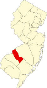 Location within the U.S. state of New Jersey | |
 New Jersey's location within the U.S. | |
| Coordinates: Coordinates: 39°48′N 74°58′W / 39.80°N 74.96°W | |
| Country | |
| State | |
| Founded | March 13, 1844 |
| Named for | Charles Pratt, 1st Earl Camden |
| Seat | Camden[1] |
| Largest municipality | Camden (population) Winslow Township (area) |
| Government | |
| • Freeholder Director | Louis Cappelli Jr. (D) |
| Area | |
| • Total | 227.293 sq mi (588.69 km2) |
| • Land | 221.263 sq mi (573.07 km2) |
| • Water | 6.030 sq mi (15.62 km2) 2.32% |
| Population (2010) | |
| • Total | 513,657 |
| • Estimate (2019) | 506,471 |
| • Density | 2,300/sq mi (870/km2) |
| Congressional districts | 1st, 2nd |
| Website | www |


Camden County is a county located in the U.S. state of New Jersey. Its county seat is Camden.[1] As of the 2019 Census estimate, the county's population was 506,471, making it the state's 8th-largest county,[2][3][4] representing a 1.4% decrease from the 513,657 enumerated at the 2010 Census,[5] in turn having increased by 4,725 (up 0.9%, the third-lowest growth rate in the state) from the 508,932 counted in the 2000 Census.[6][7][8] The most populous place was Camden, with 77,344 residents at the time of the 2010 Census, while Winslow Township covered 58.19 square miles (150.7 km2), the largest total area of any municipality.[8]
The county was formed on March 13, 1844, from portions of Gloucester County.[9] The county was named for Charles Pratt, 1st Earl Camden, a British judge, civil libertarian, and defender of the American cause.[10][11][12]
The county is part of the Camden, NJ Metropolitan Division of the Philadelphia-Camden-Wilmington, PA-NJ-DE-MD / Delaware Valley Metropolitan Statistical Area.[13][14]
Geography[]
According to the 2010 Census, the county had a total area of 227.293 square miles (588.69 km2), including 221.263 square miles (573.07 km2) of land (97.3%) and 6.030 square miles (15.62 km2) of water (2.7%).[15]
Located in a coastal / alluvial plain, the county is uniformly flat and low-lying. The highest points are a survey benchmark near the Burlington County line at 219 feet (67 m) above sea level.[16] The low point is sea level, along the Delaware River.
Adjacent counties[]
The county borders the following counties:[17]
- Burlington County – northeast
- Atlantic County – southeast
- Gloucester County – southwest
- Philadelphia County, Pennsylvania – northwest
National protected area[]
- Great Egg Harbor Scenic and Recreational River (part)
Climate and weather[]
| Camden, New Jersey | ||||||||||||||||||||||||||||||||||||||||||||||||||||||||||||
|---|---|---|---|---|---|---|---|---|---|---|---|---|---|---|---|---|---|---|---|---|---|---|---|---|---|---|---|---|---|---|---|---|---|---|---|---|---|---|---|---|---|---|---|---|---|---|---|---|---|---|---|---|---|---|---|---|---|---|---|---|
| Climate chart (explanation) | ||||||||||||||||||||||||||||||||||||||||||||||||||||||||||||
| ||||||||||||||||||||||||||||||||||||||||||||||||||||||||||||
| ||||||||||||||||||||||||||||||||||||||||||||||||||||||||||||
In recent years, average temperatures in the county seat of Camden have ranged from a low of 26 °F (−3 °C) in January to a high of 87 °F (31 °C) in July, although a record low of −11 °F (−24 °C) was recorded in February 1934 and a record high of 106 °F (41 °C) was recorded in August 1918. Average monthly precipitation ranged from 2.75 inches (70 mm) in February to 4.35 inches (110 mm) in July.[18] The county has a humid subtropical climate (Cfa). Average monthly temperatures in Chesilhurst range from 33.1 °F in January to 76.4 °F in July. [3]
Demographics[]
| Historical population | |||
|---|---|---|---|
| Census | Pop. | %± | |
| 1850 | 25,422 | — | |
| 1860 | 34,457 | 35.5% | |
| 1870 | 46,193 | 34.1% | |
| 1880 | 62,942 | 36.3% | |
| 1890 | 87,687 | 39.3% | |
| 1900 | 107,643 | 22.8% | |
| 1910 | 142,029 | 31.9% | |
| 1920 | 190,508 | 34.1% | |
| 1930 | 252,312 | 32.4% | |
| 1940 | 255,727 | 1.4% | |
| 1950 | 300,743 | 17.6% | |
| 1960 | 392,035 | 30.4% | |
| 1970 | 456,291 | 16.4% | |
| 1980 | 471,650 | 3.4% | |
| 1990 | 502,824 | 6.6% | |
| 2000 | 508,932 | 1.2% | |
| 2010 | 513,657 | 0.9% | |
| 2019 (est.) | 506,471 | [19] | −1.4% |
| Historical sources: 1790–1990[20] 1970–2010[8] 2000[6] 2010-2019[5] | |||
Camden County has 37 municipalities of diverse size and population. Nine are less than one square mile in area, and five have fewer than 2,000 residents (excluding Tavistock and Pine Valley which are golf courses with nominal populations). Over half of county residents live in five municipalities having populations over 30,000 (Camden, Cherry Hill, Gloucester Township, Winslow, Pennsauken).[21]
The 2018 ACS estimates[22] show 25 municipalities with poverty rates below the statewide average (10.5%). Nine municipalities had poverty rates higher than the county-wide estimate (12.6%): Camden, Woodlynne, Chesilhurst, Lawnside, Bellmawr, Clementon, Blackwood, Brooklawn, and Lindenwold. Additionally, Cherry Hill and Voorhees are affluent areas with higher-poverty areas including Echelon and Ellisburg.
2010 Census[]
The 2010 United States census counted 513,657 people, 190,980 households, and 129,866 families in the county. The population density was 2,321.5 per square mile (896.3/km2). There were 204,943 housing units at an average density of 926.2 per square mile (357.6/km2). The racial makeup was 65.29% (335,389) White, 19.55% (100,441) Black or African American, 0.31% (1,608) Native American, 5.11% (26,257) Asian, 0.03% (165) Pacific Islander, 7.08% (36,354) from other races, and 2.62% (13,443) from two or more races. Hispanic or Latino of any race were 14.24% (73,124) of the population.[5]
Of the 190,980 households, 31.1% had children under the age of 18; 46.3% were married couples living together; 16.4% had a female householder with no husband present and 32% were non-families. Of all households, 26.3% were made up of individuals and 10% had someone living alone who was 65 years of age or older. The average household size was 2.65 and the average family size was 3.22.[5]
24.4% of the population were under the age of 18, 9% from 18 to 24, 26.6% from 25 to 44, 27.2% from 45 to 64, and 12.8% who were 65 years of age or older. The median age was 37.9 years. For every 100 females, the population had 93.2 males. For every 100 females ages 18 and older there were 89.7 males.[5]
2000 Census[]
As of the 2000 United States Census[23] there were 508,932 people, 185,744 households, and 129,835 families residing in the county. The population density was 2,289 people per square mile (884/km2). There were 199,679 housing units at an average density of 898 per square mile (347/km2). The racial makeup of the county was 70.88% White American, 18.09% Black or African American, 0.26% Native American, 3.72% Asian, 0.04% Pacific Islander, 5.09% from other races, and 1.93% from two or more races. 9.66% of the population were Hispanic or Latino of any race.[6][24] Among those residents listing their ancestry, 20.6% of residents were of Irish, 18.2% Italian, 15.7% German and 8.1% English ancestry.[24][25]
There were 185,744 households, out of which 34.6% had children under the age of 18 living with them, 49.8% were married couples living together, 15.4% had a female householder with no husband present, and 30.1% were non-families. 25.1% of all households were made up of individuals, and 9.7% had someone living alone who was 65 years of age or older. The average household size was 2.68 and the average family size was 3.23.[6]
In the county, the population was spread out, with 26.8% under the age of 18, 8.1% from 18 to 24, 30.5% from 25 to 44, 22.1% from 45 to 64, and 12.5% who were 65 years of age or older. The median age was 36 years. For every 100 females there were 93.2 males. For every 100 females age 18 and over, there were 89.1 males.[6]
The median income for a household in the county was $48,097, and the median income for a family was $57,429. Males had a median income of $41,609 versus $30,470 for females. The per capita income for the county was $22,354. About 8.1% of families and 10.4% of the population were below the poverty line, including 14.5% of those under age 18 and 8.1% of those age 65 or over.[24][26]
Economy[]
Based on data from the Bureau of Economic Analysis, Camden County had a gross domestic product (GDP) of $23.8 billion in 2018, which was ranked 11th in the state and represented an increase of 2.5% from the previous year.[27]
Government[]
The county is governed by a Board of Chosen Freeholders consisting of seven members chosen at-large in partisan elections for three-year terms on a staggered basis by the residents of the county, with either two or three seats up for election each year as part of the November general election. At a reorganization meeting held in January after each election, the newly constituted Freeholder Board selects one of its members to serve as Director and another as Deputy Director.[28] In 2016, freeholders were paid $23,000 and the freeholder director was paid an annual salary of $24,000.[29]
As of 2020, Camden County's Freeholders are:[28][30][31][32]
- Freeholder Director Louis Cappelli Jr. (D, Collingswood, term as freeholder and director ends December 31, 2020)[33]
- Freeholder Deputy Director Edward T. McDonnell (D, Pennsauken Township, term as freeholder ends 2022; term as deputy director ends 2020)[34]
- Melinda Kane (D, Cherry Hill, 2021; elected to serve an unexpired term)[35]
- Jeffrey L. Nash (D, Cherry Hill, 2021)[36]
- Carmen G. Rodriguez (D, Merchantville, 2019)[37]
- Jonathan L. Young Sr. (D, Berlin Township, 2020)[38]
- Barbara Holcomb (D, Winslow Township, 2021; appointed to serve an unexpired term on an interim basis until the November 2020 general election)[39]
In January 2020, Susan Angulo Chin resigned from her seat as freeholder expiring in December 2021 after she took office as Mayor of Cherry Hill.[40] Barbara Holcomb was appointed to fill the seat, now serving on an interim basis until the November 2020 general election.[39]
In March 2019, Melinda Kane was appointed to fill the seat expiring in December 2021 that had been held by Bill Moen, who resigned from office to run for a seat in the New Jersey General Assembly.[41] Kane served on an interim basis until the November 2019 general election, when she was elected to serve the balance of the term of office.[30]
Pursuant to Article VII Section II of the New Jersey State Constitution, each county in New Jersey is required to have three elected administrative officials known as "constitutional officers." These officers are the County Clerk and County Surrogate (both elected for five-year terms of office) and the County Sheriff (elected for a three-year term).[42] Camden County's constitutional officers, all elected directly by voters, are:[43]
- County Clerk Joseph Ripa (D, Voorhees Township, 2024)[44][45]
- Sheriff Gilbert "Whip" Wilson (D, Camden, 2021)[46][47]
- Surrogate Michelle Gentek-Mayer (D, Gloucester Township, 2020)[48][49]
The Acting County Prosecutor is Jill S. Mayer, who was sworn in on October 1, 2019.[50]
Camden County constitutes Vicinage 4 of the New Jersey Superior Court, which is seated at the Camden County Hall of Justice in Camden, with additional facilities at various locations in Cherry Hill. The Assignment Judge for the vicinage is Deborah Silverman Katz.[51] As with most counties in the state, the court system in Camden County also includes municipal courts for each township, borough and city to handle traffic and other minor items.
Law enforcement at the county level, in addition to a sheriff, includes the Camden County Police Department and the Camden County Prosecutor's Office. The Camden Police Department and the Camden County Park Police were absorbed into the newly formed Camden County Police Department in 2013.[52]
Federal Representatives[]
Two federal Congressional Districts cover the county, including portions of the 1st and 2nd Districts.[53][54] For the 117th United States Congress, New Jersey's First Congressional District is represented by Donald Norcross (D, Camden).[55][56] For the 117th United States Congress, New Jersey's Second Congressional District is represented by Jeff Van Drew (R, Dennis Township).[57]
State Representatives[]
| District | Senator[58] | Assembly[58] | Municipalities |
|---|---|---|---|
| 4th | Fred H. Madden (D) | Paul D. Moriarty (D) | Chesilhurst, Clementon, Gloucester Township, Laurel Springs and
Lindenwold. The remainder of this district covers portions of Gloucester County. |
| 5th | Nilsa Cruz-Perez (D) | William Spearman (D)
Bill Moen (D) |
Audubon, Audubon Park, Barrington, Bellmawr, Brooklawn, Camden, Gloucester City,
Haddon Heights, Lawnside, Magnolia, Mount Ephraim, Runnemede and Woodlynne. The remainder of this district covers portions of Gloucester County. |
| 6th | James Beach (D) | Louis Greenwald (D) | Berlin Township, Cherry Hill, Collingswood, Gibbsboro, Haddon Township, Haddonfield Borough,
Hi-Nella Borough, Merchantville Borough, Oaklyn Borough, Pennsauken Township, Somerdale Borough, Stratford Borough, Tavistock Borough and Voorhees Township. The remainder of this district covers portions of Burlington County. |
| 8th | Dawn Addiego (D) | Ryan Peters (R)
Jean Stanfield (R) |
Berlin Borough, Pine Hill Borough, Pine Valley Borough and Waterford Township.
The remainder of this district covers portions of Atlantic County and Burlington County. |
The county is part of the 4th, 5th, 6th and 8th Districts in the New Jersey Legislature.
Politics[]
Camden County has long been a Democratic stronghold, and almost all of the county is in the 1st congressional district (which has a Cook Partisan Voting Index score of D+13). The county usually votes overwhelmingly Democratic in national, state, and local elections.
As of August 1, 2020, there were a total of 376,429 registered voters in Camden County, of whom 178,834 (47.5%) were registered as Democrats, 57,545 (15.3%) were registered as Republicans and 134,908 (35.8%) were registered as Unaffiliated. There were 5,142 (1.4%) voters registered to other parties.[59] Among the county's 2010 Census population, 69.1% were registered to vote, including 75.6% of those ages 18 and over.[60][61]
In the 2016 U.S. presidential election, Hillary Clinton carried the country by a 32.4% margin over Donald Trump, while Clinton won New Jersey by 14.1%. In the 2004 U.S. presidential election, John Kerry carried the county by a 25.5% margin over George W. Bush, with Kerry carrying the state by 6.7% over Bush.[62] Barack Obama carried the county by 34.8% over John McCain in the 2008 U.S. presidential election, while Obama won New Jersey by 14.7%.[63]
Municipalities[]


Municipalities in Camden County (with 2010 Census data for population, housing units and area) are:[65]
| Municipality (with map key) |
Map key | Mun. type |
Pop. | Housing units |
Total area |
Water area |
Land Area |
Pop. density |
Housing density |
School district | Communities[66] |
|---|---|---|---|---|---|---|---|---|---|---|---|
| Audubon | 9 | borough | 8,819 | 3,779 | 1.50 | 0.02 | 1.49 | 5,925.7 | 2,539.2 | Audubon | |
| Audubon Park | 6 | borough | 1,023 | 499 | 0.16 | 0.01 | 0.15 | 7,046.7 | 3,437.3 | Audubon (S/R) | |
| Barrington | 16 | borough | 6,983 | 3,158 | 1.61 | 0.00 | 1.61 | 4,346.0 | 1,965.4 | Haddon Heights (9-12) (S/R) Barrington (K-8) |
|
| Bellmawr | 12 | borough | 11,583 | 4,883 | 3.11 | 0.13 | 2.98 | 3,887.7 | 1,638.9 | Black Horse Pike (9-12) Bellmawr (PK-8) |
|
| Berlin | 28 | borough | 7,588 | 2,949 | 3.60 | 0.01 | 3.59 | 2,114.9 | 821.9 | E. Camden County (9-12) Berlin Borough (PK-8) |
New Freedom |
| Berlin Township | 32 | township | 5,357 | 2,069 | 3.24 | 0.01 | 3.23 | 1,657.5 | 640.2 | Pine Hill (9-12) (S/R) Berlin Township (PK-8) |
West Berlin |
| Brooklawn | 11 | borough | 1,955 | 806 | 0.52 | 0.03 | 0.49 | 3,974.6 | 1,638.6 | Gloucester City (9-12) (S/R) Brooklawn (PK-8) |
|
| Camden | 2 | city | 77,344 | 28,358 | 10.34 | 1.42 | 8.92 | 8,669.6 | 3,178.7 | Camden | |
| Cherry Hill | 35 | township | 71,045 | 28,452 | 24.24 | 0.15 | 24.10 | 2,948.3 | 1,180.7 | Cherry Hill | Ashland CDP (8,302) Barclay CDP (4,428) Cherry Hill Mall CDP (14,171) Coffins Corner Ellisburg CDP (4,413) Golden Triangle CDP (4,145) Greentree CDP (11,367) Kingston Estates CDP (5,685) Springdale CDP (14,518) Woodcrest |
| Chesilhurst | 29 | borough | 1,634 | 621 | 1.72 | 0.00 | 1.72 | 951.2 | 361.5 | Winslow Township (S/R) | |
| Clementon | 25 | borough | 5,000 | 2,235 | 1.97 | 0.06 | 1.91 | 2,612.0 | 1,167.6 | Pine Hill (9-12) (S/R) Clementon (PK-8) |
|
| Collingswood | 3 | borough | 13,926 | 6,822 | 1.92 | 0.10 | 1.82 | 7,639.4 | 3,742.3 | Collingswood | |
| Gibbsboro | 24 | borough | 2,274 | 809 | 2.22 | 0.04 | 2.18 | 1,041.9 | 370.7 | E. Camden County (9-12) Gibbsboro (K-8) |
|
| Gloucester City | 5 | city | 11,456 | 4,712 | 2.78 | 0.46 | 2.32 | 4,937.8 | 2,031.0 | Gloucester City | |
| Gloucester Township | 33 | township | 64,634 | 24,711 | 23.26 | 0.28 | 22.98 | 2,812.2 | 1,075.2 | Black Horse Pike (9-12) Gloucester Township (K-8) |
Blackwood CDP (4,545) Blenheim Chews Landing Erial Glendora CDP (4,750) Grenloch Lakeland |
| Haddon Township | 36 | township | 14,707 | 6,477 | 2.79 | 0.10 | 2.69 | 5,472.6 | 2,410.1 | Haddon Township | |
| Haddonfield | 8 | borough | 11,593 | 4,634 | 2.87 | 0.05 | 2.82 | 4,104.9 | 1,640.8 | Haddonfield | |
| Haddon Heights | 13 | borough | 7,473 | 3,159 | 1.57 | 0.01 | 1.57 | 4,764.1 | 2,013.9 | Haddon Heights | |
| Hi-Nella | 20 | borough | 870 | 420 | 0.23 | 0.00 | 0.23 | 3,773.3 | 1,821.6 | Sterling (9-12) (S/R) Stratford (PK-8) (S/R) |
|
| Laurel Springs | 22 | borough | 1,908 | 771 | 0.47 | 0.01 | 0.46 | 4,163.7 | 1,682.5 | Sterling (9-12) (S/R) Stratford (7-8) (S/R) Laurel Springs (K-6) |
|
| Lawnside | 15 | borough | 2,945 | 1,174 | 1.41 | 0.00 | 1.41 | 2,091.5 | 833.7 | Haddon Heights (9-12) (S/R) Lawnside (K-8) |
|
| Lindenwold | 23 | borough | 17,613 | 8,251 | 3.95 | 0.06 | 3.89 | 4,525.1 | 2,119.8 | Lindenwold | |
| Magnolia | 18 | borough | 4,341 | 1,850 | 0.97 | 0.00 | 0.97 | 4,485.3 | 1,911.5 | Sterling (9-12) Magnolia (PK-8) |
|
| Merchantville | 1 | borough | 3,821 | 1,688 | 0.60 | 0.00 | 0.60 | 6,371.3 | 2,814.6 | Haddon Heights (9-12) (S/R) Merchantville (PK-8) |
|
| Mount Ephraim | 10 | borough | 4,676 | 2,010 | 0.90 | 0.02 | 0.88 | 5,307.9 | 2,281.6 | Audubon (9-12) (S/R) Mount Ephraim (PK-8) |
|
| Oaklyn | 7 | borough | 4,038 | 1,847 | 0.69 | 0.07 | 0.63 | 6,432.9 | 2,942.4 | Collingswood (6-12) (S/R) Oaklyn (K-5) |
|
| Pennsauken Township |
37 | township | 35,885 | 13,275 | 12.08 | 1.65 | 10.44 | 3,438.9 | 1,272.2 | Pennsauken | |
| Pine Hill | 26 | borough | 10,233 | 4,357 | 3.91 | 0.04 | 3.87 | 2,643.4 | 1,125.5 | Pine Hill | |
| Pine Valley | 27 | borough | 12 | 22 | 1.00 | 0.02 | 0.98 | 12.2 | 22.4 | Haddonfield (S/R) | |
| Runnemede | 17 | borough | 8,468 | 3,548 | 2.11 | 0.06 | 2.06 | 4,117.2 | 1,725.1 | Black Horse Pike (9-12) Runnemede (PK-8) |
|
| Somerdale | 19 | borough | 5,151 | 2,158 | 1.39 | 0.00 | 1.39 | 3,714.0 | 1,556.0 | Sterling (9-12) Somerdale (PK-8) |
|
| Stratford | 21 | borough | 7,040 | 2,761 | 1.55 | 0.00 | 1.55 | 4,547.0 | 1,783.3 | Sterling (9-12) Stratford (PK-8) |
|
| Tavistock | 14 | borough | 5 | 3 | 0.26 | 0.00 | 0.25 | 19.7 | 11.8 | Haddonfield (S/R) | |
| Voorhees Township |
34 | township | 29,131 | 12,260 | 11.64 | 0.15 | 11.49 | 2,534.9 | 1,066.8 | E. Camden County (9-12) Voorhees (K-8) |
Echelon CDP (10,743) Glendale Kirkwood Kresson Osage Woodcrest Acres |
| Waterford Township |
31 | township | 10,649 | 3,839 | 36.27 | 0.23 | 36.04 | 295.5 | 106.5 | Hammonton (7-12) (S/R) Waterford Township (PK-6) |
Atco Jackson |
| Winslow Township |
30 | township | 39,499 | 14,560 | 58.19 | 0.85 | 57.34 | 688.8 | 253.9 | Winslow Township | Ancora Blue Anchor Braddock Cedar Brook Ivystone Farms Sicklerville Tansboro Waterford Works West Atco |
| Woodlynne | 4 | borough | 2,978 | 1,016 | 0.23 | 0.01 | 0.22 | 13,600.4 | 4,640.0 | Collingswood (9-12) (S/R) Woodlynne (K-5) |
|
| Camden County | county | 513,657 | 204,943 | 227.29 | 6.03 | 221.26 | 2,321.5 | 926.2 |
Historical municipalities[]
Defunct municipalities in the county (with years of formation and dissolution listed in parentheses) include:[9]
- Centre Township (1855–1926)
- Clementon Township (1903–1941)
- Delaware Township (renamed as Cherry Hill)
- Newton Township (1695–1871)
- Stockton Township (1859–1899)
- Union Township (1831–1868)
Education[]
Colleges and universities[]
Rutgers University-Camden is located in the downtown/waterfront district of Camden, and dates back to 1926 with the founding of the South Jersey Law School.[67][68]
Rutgers School of Law–Camden is one of two campuses of Rutgers Law School, the other being in Newark.[69]
The Rowan University School of Osteopathic Medicine is located in Stratford and dates to 1976. It is the state's only osteopathic medical school and was South Jersey's first four-year college of medicine.[70]
The Cooper Medical School of Rowan University is located in the downtown/university district of Camden. Established as a four-year medical school in 1975, the relationship with Rowan University was formed in 2008.[71]
Rutgers Biomedical and Health Sciences has a campus in Stratford which hosts its dental school and school of public health.[72]
Rowan University at Camden is located on Cooper Street in Camden and offers undergraduate and graduate degrees.[73]
Camden County College is a two-year public community college serving students from Camden County. The school has campuses in Blackwood, Camden and Cherry Hill, and was founded in 1967.[74]
Arts and culture[]
Fine and performing arts[]
The Ritz Theater in Haddon Township, constructed in 1927 and listed on the National Register of Historic Places, hosts theater performances and film festivals.[75]
Symphony in C was established as The Haddonfield Symphony in 1952 and is based on the campus of Rutgers University-Camden.[76]
Perkins Center for the Arts has locations in Moorestown and Collingswood.[77]
The Scottish Rite Auditorium in Collingswood, recognized on the American Institute of Architects's list of "150 Best Buildings and Places" in New Jersey, hosts national music and theater performances.[78]
Literature[]
Poet Walt Whitman lived in Camden County.
Matthew Quick's novel The Silver Linings Playbook is set in Collingswood and Voorhees, although the screen adaptation is set in Pennsylvania.[79]
Poet Nick Virgilio was born in Camden, NJ and returned to Camden in 1958.[80]
Film[]
The Last Broadcast was partially filmed in the Pine Barrens.[citation needed]
Harold & Kumar Go to White Castle is partially set in Cherry Hill.[81]
Camden was the setting for several scenes in 12 Monkeys.
Transportation[]
Roads and highways[]
Camden County hosts numerous county, state, U.S. and Interstates. As of October 2015, the county had a total of 2,045.06 miles (3,291.21 km) of roadways, of which 1,535.22 miles (2,470.70 km) are maintained by the municipality, 377.65 miles (607.77 km) by Camden County and 104.41 miles (168.03 km) by the New Jersey Department of Transportation, 5.11 miles (8.22 km) by the Delaware River Port Authority, 9.07 miles (14.60 km) by the New Jersey Turnpike Authority and 13.60 miles (21.89 km) by the South Jersey Transportation Authority.[82]
Major county roads that pass through include County Road 534, County Road 536, County Road 537, County Road 543, County Road 544, County Road 551 and County Road 561.
State routes that pass through are Route 38, Route 41, Route 42 (the North-South Freeway), Route 47 (only in Brooklawn), Route 70, Route 73, Route 90 (the Betsy Ross Bridge), Route 143 (only in Winslow), Route 154 (only in Cherry Hill) and Route 168.
U.S. Routes that traverse are U.S. Route 30 and U.S. Route 130.
The interstates that pass through are Interstate 76 (part of the North-South Freeway and the Walt Whitman Bridge), Interstate 295 and Interstate 676 (part of the North-South Freeway and the Ben Franklin Bridge (which is multiplexed with US 30)).
Other limited access roads that pass through are the Atlantic City Expressway and the New Jersey Turnpike. There are five ACE interchanges that are within the county borders: Exits 44 (at NJ 42),[83] 41 (at Berlin-Cross Keys Road / CR 689),[84] 38 (at Williamstown-New Freedom Road / CR 536 Spur),[85] 33 (connecting to NJ 73)[85] and 31 (at NJ 73).[86][87] The only turnpike interchange that is in the county is Exit 3 at the border of Runnemede and Bellmawr.[88]
Public transportation[]
NJ Transit has stations along the Atlantic City Line in Pennsauken, Cherry Hill, Lindenwold and Atco in Waterford Township, connecting Philadelphia to Atlantic City along the former Pennsylvania-Reading Seashore Lines main line.[89]
The River Line is a diesel tram-train light-rail system operated for NJ Transit by the Southern New Jersey Rail Group on a former Pennsylvania Railroad line from Trenton. Most stations in the county are in the Camden, including the Walter Rand Transportation Center, except for the 36th Street, Pennsauken Transit Center and located in Pennsauken Township.[90]
The PATCO Speedline, owned by the Delaware River Port Authority, runs a rapid transit line across the Ben Franklin Bridge from Philadelphia through Camden to the PRSL main right-of-way between Haddonfield and its eastern terminus in Lindenwold. Suburban station stops include Woodcrest, Westmont and Collingswood.[91]
NJ Transit provides commuter and long-distance bus service from many locations in the county to Philadelphia, with additional service to Atlantic City. Extensive local service is offered within the county, including routes to Camden and area train and light rail stations.[92]
Wineries, breweries, and distilleries[]
- Amalthea Cellars (located in the West Atco portion of Winslow Township)
- Devil's Creek Brewery (Collingswood)
- Tonewood Brewing (Oaklyn)
- Flying Fish Brewing (headquartered in Somerdale)
- Sharrott Winery (located in the Blue Anchor section of Winslow Township)
See also[]
 Philadelphia portal
 New Jersey portal
- National Register of Historic Places listings in Camden County, New Jersey
References[]
- ^ Jump up to: a b New Jersey County Map Archived March 13, 2017, at the Wayback Machine, New Jersey Department of State. Accessed July 10, 2017.
- ^ QuickFacts – Camden County, New Jersey; New Jersey; United States Archived 2018-05-01 at the Wayback Machine, United States Census Bureau. Accessed March 24, 2018.
- ^ Annual Estimates of the Resident Population: April 1, 2010 to July 1, 2017 - 2017 Population Estimates Archived February 13, 2020, at archive.today, United States Census Bureau. Accessed March 24, 2018.
- ^ GCT-PEPANNCHG: Estimates of Resident Population Change and Rankings: July 1, 2016 to July 1, 2017 - State -- County / County Equivalent from the 2017 Population Estimates for New Jersey Archived February 13, 2020, at archive.today, United States Census Bureau. Accessed March 24, 2018.
- ^ Jump up to: a b c d e DP1 – Profile of General Population and Housing Characteristics: 2010 Demographic Profile Data for Camden County, New Jersey, United States Census Bureau. Accessed March 25, 2016.
- ^ Jump up to: a b c d e DP-1 – Profile of General Demographic Characteristics: 2000; Census 2000 Summary File 1 (SF 1) 100-Percent Data for Camden County, New Jersey, United States Census Bureau. Accessed January 21, 2013.
- ^ NJ Labor Market Views Archived 2013-09-20 at the Wayback Machine, New Jersey Department of Labor and Workforce Development, March 15, 2011. Accessed October 3, 2013.
- ^ Jump up to: a b c New Jersey: 2010 - Population and Housing Unit Counts; 2010 Census of Population and Housing Archived July 23, 2013, at the Wayback Machine, p. 6, CPH-2-32. United States Census Bureau, August 2012. Accessed August 29, 2016.
- ^ Jump up to: a b Snyder, John P. The Story of New Jersey's Civil Boundaries: 1606–1968 Archived June 5, 2012, at the Wayback Machine, Bureau of Geology and Topography; Trenton, New Jersey; 1969. p. 103. Accessed January 20, 2013.
- ^ Greenberg, Gail. County History Archived 2011-07-20 at the Wayback Machine, Camden County, New Jersey. Accessed October 9, 2013. "The namesake of the new settlement was Charles Pratt, Earl of Camden, an English nobleman who supported the American cause in Parliament."
- ^ Hutchinson, Viola L. The Origin of New Jersey Place Names Archived September 23, 2015, at Wikiwix, New Jersey Public Library Commission, May 1945. Accessed August 28, 2015.
- ^ Gannett, Henry. The Origin of Certain Place Names in the United States, p. 65. United States Government Printing Office, 1905. Accessed August 28, 2015.
- ^ May 2012 Metropolitan and Nonmetropolitan Area Definitions Archived June 2, 2013, at the Wayback Machine, Bureau of Labor Statistics. Accessed October 9, 2013.
- ^ Revised Delineations of Metropolitan Statistical Areas, Micropolitan Statistical Areas, and Combined Statistical Areas, and Guidance on Uses of the Delineations of These Areas Archived January 21, 2017, at the Wayback Machine, Office of Management and Budget, February 28, 2013. Accessed October 9, 2013.
- ^ Census 2010 U.S. Gazetteer Files: New Jersey Counties Archived 2015-05-18 at the Wayback Machine, United States Census Bureau. Accessed May 12, 2015.
- ^ New Jersey County High Points Archived 2015-05-18 at the Wayback Machine, Peakbagger.com. Accessed October 3, 2013.
- ^ Areas touching Camden County Archived 2015-05-18 at the Wayback Machine, MapIt. Accessed May 12, 2015.
- ^ Jump up to: a b Monthly Averages for Camden, New Jersey, The Weather Channel. Accessed October 13, 2012.
- ^ "Population and Housing Unit Estimates". Retrieved March 26, 2020.
- ^ Forstall, Richard L. Population of states and counties of the United States: 1790 to 1990 from the Twenty-one Decennial Censuses, pp. 108–109. United States Census Bureau, March 1996. ISBN 9780934213486. Accessed October 3, 2013.
- ^ [1], United States Census Bureau. Accessed November 23, 2020.
- ^ [2] , United States Census Bureau. Accessed November 23, 2020.
- ^ U.S. Census website , United States Census Bureau. Accessed September 4, 2014.
- ^ Jump up to: a b c Tables DP-1 to DP-4 from Census 2000 for Somerset County, New Jersey, United States Census Bureau, backed up by the Internet Archive as of July 6, 2008. Accessed October 3, 2013.
- ^ DP-2 – Profile of Selected Social Characteristics: 2000 from the Census 2000 Summary File 3 (SF 3) – Sample Data for Camden County, New Jersey, United States Census Bureau. Accessed September 30, 2013.
- ^ DP-3 – Profile of Selected Economic Characteristics: 2000 from Census 2000 Summary File 3 (SF 3) – Sample Data for Camden County, New Jersey, United States Census Bureau. Accessed September 30, 2013.
- ^ Local Area Gross Domestic Product, 2018, Bureau of Economic Analysis, released December 12, 2019. Accessed December 12, 2019.
- ^ Jump up to: a b About the Freeholder Board, Camden County, New Jersey. Accessed June 6, 2018.
- ^ Gallo Jr., Bill. "Which N.J. county freeholders are paid the most?", NJ.com, March 11, 2016. Accessed June 6, 2018. "Freeholder director: $24,000; Other freeholders: $23,000"
- ^ Jump up to: a b Official Election Results 2019 General Election November 5, 2019, Camden County, New Jersey, as of November 13, 2019. Accessed January 1, 2020.
- ^ Official Election Results 2018 General Election November 6, 2018, Camden County, New Jersey, as of December 4, 2018. Accessed January 1, 2019.
- ^ Official Election Results 2017 General Election November 7, 2017, Camden County, New Jersey, as of November 16, 2017. Accessed January 1, 2018.
- ^ Louis Cappelli Jr., Camden County, New Jersey. Accessed January 30, 2020.
- ^ Edward T. McDonnell, Camden County, New Jersey. Accessed January 30, 2020.
- ^ Melinda Kane, Camden County, New Jersey. Accessed January 30, 2020.
- ^ Jeffrey L. Nash, Camden County, New Jersey. Accessed January 30, 2020.
- ^ Carmen Rodriguez, Camden County, New Jersey. Accessed January 30, 2020.
- ^ Jonathan L. Young Sr., Camden County, New Jersey. Accessed January 30, 2020.
- ^ Jump up to: a b Walsh, Jim. "Barbara Holcomb of Winslow joins Camco freeholder board". Courier-Post. Retrieved 2020-02-11.
- ^ Walsh, Jim. "Susan Shin Angulo takes office as Cherry Hill's first Korean-American mayor", Courier-Post, January 3, 2020. Accessed January 30, 2020. "Susan Shin Angulo became the township’s first Korean-American mayor Thursday, taking the oath of office at a ceremony that featured speeches, prayers and pounding drums. 'I stand before you as a woman and mother, a first-generation college graduate, and an immigrant whose family overcame poverty in pursuit of the American Dream,' said Angulo, a Democrat who resigned earlier Thursday as a Camden County freeholder."
- ^ Walsh, Jim. "Gold Star Mother Melinda Kane named to freeholder board", Courier-Post, March 29, 2019. Accessed January 30, 2020. "Melinda Kane, a two-term Cherry Hill councilwoman, replaced Bill Moen Jr. on the all-Democratic freeholder board. Moen resigned March 22 to run for a 5th District Assembly seat.... Kane, who resigned from Cherry Hill’s council earlier Thursday, was named a freeholder at a meeting of Camden County’s Democratic Committee. An election will be held in November to fill Moen’s unexpired term."
- ^ New Jersey State Constitution (1947), Article VII, Section II, Paragraph 2, New Jersey Department of State. Accessed October 26, 2017.
- ^ Your Government, Camden County, New Jersey. Accessed June 6, 2018.
- ^ County Clerk Joseph Ripa, Camden County, New Jersey. Accessed January 30, 2020.
- ^ Members List: Clerks Archived 2017-10-23 at the Wayback Machine, Constitutional Officers Association of New Jersey. Accessed June 6, 2018.
- ^ Sheriff Gilbert "Whip" Wilson, Camden County, New Jersey. Accessed January 30, 2020.
- ^ Members List: Sheriffs Archived 2017-10-23 at the Wayback Machine, Constitutional Officers Association of New Jersey. Accessed June 6, 2018.
- ^ Surrogate Michelle Gentek-Mayer, Camden County, New Jersey. Accessed January 30, 2020.
- ^ Members List: Surrogates Archived 2017-10-23 at the Wayback Machine, Constitutional Officers Association of New Jersey. Accessed June 6, 2018.
- ^ "Staff - Office of the Prosecutor Camden County". Office of the Prosecutor Camden County. Retrieved 2020-01-30.
- ^ Camden County, New Jersey Courts. Accessed June 6, 2018.
- ^ Maciag, Mike. " Why Camden, N.J., the Murder Capital of the Country, Disbanded Its Police ForceIn hopes of reducing the city's high crime rate, Camden, N.J., made a controversial and unprecedented move a year ago to replace its police force. " Archived 2017-10-27 at the Wayback Machine, Governing (magazine), June 2014. Accessed October 26, 2017. "In the face of this violence, Camden did something quite radical: It disbanded its 141-year-old police force. In its place, the surrounding county formed a new police department that it wants to expand to other jurisdictions outside the city."
- ^ 2012 Congressional Districts by County Archived 2012-05-26 at the Wayback Machine, New Jersey Department of State Division of Elections. Accessed October 3, 2013.
- ^ Plan Components Report Archived 2013-12-04 at the Wayback Machine, New Jersey Department of State Division of Elections, December 23, 2011. Accessed October 3, 2013.
- ^ Directory of Representatives: New Jersey, United States House of Representatives. Accessed January 3, 2019.
- ^ Full Biography, Congressman Donald Norcross. Accessed January 3, 2019. "Donald and his wife Andrea live in Camden City and are the proud parents of three grown children and grandparents of two."
- ^ Directory of Representatives: New Jersey, United States House of Representatives. Accessed January 3, 2019.
- ^ Jump up to: a b "New Jersey Legislature - Legislative Roster". www.njleg.state.nj.us. Retrieved 2021-05-25.
- ^ "NJ Voter Registration by County" (PDF). NJ Division of Elections.
- ^ Statewide Voter Registration Summary Archived December 22, 2014, at the Wayback Machine, New Jersey Department of State Division of Elections, as of October 31, 2014. Accessed May 11, 2015.
- ^ GCT-P7: Selected Age Groups: 2010 – State – County / County Equivalent from the 2010 Census Summary File 1 for New Jersey, United States Census Bureau. Accessed May 11, 2015.
- ^ New Jersey Presidential Election Returns by County 2004 Archived 2008-09-14 at the Wayback Machine, Eagleton Institute of Politics at Rutgers University. Accessed August 31, 2008.
- ^ New Jersey – Election Results 2008 Archived 2008-12-17 at the Wayback Machine, The New York Times. Accessed November 28, 2008.
- ^ Leip, David. "Dave Leip's Atlas of U.S. Presidential Elections". uselectionatlas.org. Archived from the original on 23 March 2018. Retrieved 1 May 2018.
- ^ GCT-PH1: Population, Housing Units, Area, and Density: 2010 – County – County Subdivision and Place from the 2010 Census Summary File 1 for Camden County, New Jersey, United States Census Bureau. Accessed May 12, 2015.
- ^ Locality Search Archived 2016-07-09 at the Wayback Machine, State of New Jersey. Accessed May 12, 2015.
- ^ About Rutgers–Camden Archived 2013-10-04 at the Wayback Machine, Rutgers University-Camden. Accessed October 3, 2013.
- ^ Campus History Archived 2013-10-05 at the Wayback Machine, Rutgers University-Camden. Accessed October 3, 2013.
- ^ Our Locations Archived 2017-09-16 at the Wayback Machine, Rutgers Law School. Accessed March 6, 2018.
- ^ About Archived 2014-11-17 at the Wayback Machine, Rowan University School of Osteopathic Medicine. Accessed October 3, 2013.
- ^ History Archived 2015-05-23 at the Wayback Machine, Cooper Medical School of Rowan University. Accessed May 12, 2015.
- ^ "Home - Rutgers Biomedical and Health Sciences". rbhs.rutgers.edu. Archived from the original on 2 July 2014. Retrieved 1 May 2018.
- ^ Camden Campus Archived 2018-03-07 at the Wayback Machine, Rowan University. Accessed March 6, 2018.
- ^ About Us Archived 2013-10-04 at the Wayback Machine, Camden County College. Accessed October 3, 2013. "Its three distinct campuses in Blackwood, Camden and Cherry Hill – along with its satellite locations in Lakeland, Sicklerville and elsewhere throughout the County – share the common mission of providing accessible, affordable higher education and occupational study to all who can benefit.... Camden County College's mission was launched when what had been the Mother of the Savior Seminary was purchased early in 1967. That fall, the first class of Camden County College students was taking courses on what had become the Blackwood Campus."
- ^ History Archived 2017-10-27 at the Wayback Machine, Ritz Theater. Accessed October 26, 2017.
- ^ About Archived 2012-01-17 at the Wayback Machine, Symphony in C. Accessed October 26, 2017. "Founded in 1952 as The Haddonfield Symphony, Symphony in C began as a community orchestra allowing amateur musicians to pursue their love of music by performing for the Haddonfield and southern New Jersey communities. Its debut performance was in January 1954 under music director Guido Terranova."
- ^ About Archived 2017-10-27 at the Wayback Machine, Perkins Center for the Arts. Accessed October 26, 2017.
- ^ About Us Archived 2017-10-27 at the Wayback Machine, Scottish Rite Auditorium. Accessed October 26, 2017. "The Scottish Rite is one of the largest auditoriums in South Jersey. It was voted one of the '150 Best Buildings and Places' by the American Institute of Architects in the 2011 AIA New Jersey Guidebook. "
- ^ "Collingswood, N.J. native Matthew Quick: Silver Linings Playbook is 'very true to the spirit of the book'". WHYY. Retrieved 2020-11-04.
- ^ "About Nick Virgilio". Nick Virgilio Haiku Association. Retrieved 2020-11-04.
- ^ Stice, Joel. "Here Are 12 High-ly Interesting Facts About Harold & Kumar Go To White Castle On Its 10th Anniversary" Archived 2017-10-27 at the Wayback Machine, , July 30, 2014. Accessed October 26, 2017. "There were no White Castles around the movie's filming location. In the movie, Harold and Kumar are on their way from Hoboken to a White Castle location in Cherry Hill, New Jersey. But at the time there was no White Castle in Cherry Hill."
- ^ Camden County Mileage by Municipality and Jurisdiction, New Jersey Department of Transportation, March 2019. Accessed December 26, 2020.
- ^ Exit 44 Archived 2013-10-05 at the Wayback Machine, Atlantic City Expressway. Accessed October 3, 2013.
- ^ Exit 41 Archived 2013-10-05 at the Wayback Machine, Atlantic City Expressway. Accessed October 3, 2013.
- ^ Jump up to: a b Exit 33 Archived 2013-10-05 at the Wayback Machine, Atlantic City Expressway. Accessed October 3, 2013.
- ^ Exit 31 Archived 2013-10-04 at the Wayback Machine, Atlantic City Expressway. Accessed October 3, 2013.
- ^ AC Expressway Map Archived 2013-10-05 at the Wayback Machine, Atlantic City Expressway. Accessed October 3, 2013.
- ^ Travel Resources: Interchanges, Service Areas & Commuter Lots Archived 2007-12-13 at the Wayback Machine, New Jersey Turnpike Authority. Accessed October 3, 2013.
- ^ Atlantic City Rail Line Archived 2013-10-20 at the Wayback Machine, NJ Transit. Accessed October 3, 2013.
- ^ RiverLINE Map Archived 2013-10-01 at the Wayback Machine, NJ Transit. Accessed October 3, 2013.
- ^ Overview Archived 2012-09-23 at the Wayback Machine, PATCO Speedline. Accessed October 3, 2013.
- ^ Camden County Bus / Tail Connections, NJ Transit, backed up by the internet Archive as of may 22, 2009. Accessed May 13, 2015.
Further reading[]
- History of Camden County in the Great War, 1917–1918 Camden, NJ: Publicity and Historical Committee, 1919.
External links[]
| Wikimedia Commons has media related to Camden County, New Jersey. |
- Official website
- Camden County Historic Photos, Part I (Audubon, New Jersey to Camden, New Jersey)
- Camden County Historic Photos, Part II (Cherry Hill, New Jersey to Haddon Township, New Jersey)
- Camden County Historic Photos, Part III (Haddonfield, New Jersey to Pennsauken Township, New Jersey)
- Camden County Historic Photos, Part IV (Pine Hill, New Jersey to Woodlynne, New Jersey)
- Camden County Historical Society
| show Places adjacent to Camden County, New Jersey |
|---|
| show Municipalities and communities of Camden County, New Jersey, United States |
|---|

| show |
|---|
| show Delaware Valley |
|---|
| show Authority control |
|---|
- New Jersey counties
- Camden County, New Jersey
- 1844 establishments in New Jersey
- Geography of the Pine Barrens (New Jersey)
- Populated places established in 1844
- South Jersey