Canungra, Queensland
| Canungra Queensland | |||||||||||||||
|---|---|---|---|---|---|---|---|---|---|---|---|---|---|---|---|
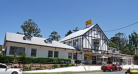 The historic Canungra Hotel | |||||||||||||||
 Canungra | |||||||||||||||
| Coordinates | 28°01′10″S 153°09′55″E / 28.0195°S 153.1652°E | ||||||||||||||
| Population | 1,229 (2016 census)[1] | ||||||||||||||
| • Density | 41.24/km2 (106.82/sq mi) | ||||||||||||||
| Postcode(s) | 4275 | ||||||||||||||
| Area | 29.8 km2 (11.5 sq mi) | ||||||||||||||
| Time zone | AEST (UTC+10:00) | ||||||||||||||
| Location |
| ||||||||||||||
| LGA(s) | Scenic Rim Region | ||||||||||||||
| State electorate(s) | Scenic Rim | ||||||||||||||
| Federal Division(s) | Wright | ||||||||||||||
| |||||||||||||||

Canungra /kəˈnʌŋɡrə/[2] is a rural town and locality in the Scenic Rim Region, Queensland, Australia.[3][4] In the 2016 census the locality of Canungra had a population of 1,229 people.[1]
Geography[]
Located in South East Queensland, Canungra is situated in the Gold Coast hinterland, 32 kilometres (20 mi) west of the Gold Coast and 75 kilometres (47 mi) south of Brisbane.[citation needed]
Mount Misery is on the north-western boundary of the locality with Biddadaba (28°00′52″S 153°08′23″E / 28.0145°S 153.1398°E) rising to 530 metres (1,740 ft) above sea level.[5][6]
Residents and businesses in Canungra get their water supply from the Canungra Creek, a tributary of the Albert River. The slopes around Canungra are steep and forested, with some cleared farmlands and rural homes in the flatter valley areas.
History[]
Nicknamed the "Valley of the Owls", one of the origins of the town's name comes from the Aboriginal word for small owls, "Caningera".[7] The most notable owl found in the area is the Australian boobook owl, which appears in various logos and symbols associated with Canungra. However the word Cunungra comes from the Yugambeh word gungunga meaning "a long flat or clearing".[8]
Canungera Upper Provisional School opened on 21 January 1889. On 1 January 1909 it became Canungera Upper State School. In 1912 the name was changed to Canungra State School.[9]
Canungra Post Office was opened by May 1907 (a receiving office had been open from 1888 under the ownership of Mrs. John Duncan, known at first as Canningera Creek).[10]
Canungra owes its existence to the timber industry and once boasted one of the largest stands of timber in the colony. David Lahey, the father of Romeo Lahey, owned one of Queensland's largest sawmills at Canungra (Lahey's Canungra Sawmill).[11]
From 2 July 1915 until 1 July 1955 the Canungra railway line ran from the Beaudesert line at Logan Village to Canungra railway station (28°01′04″S 153°09′45″E / 28.0179°S 153.1625°E).[12]
In 1916 the Lahey family built the Bellissima guest house. In 1927 it was sold and extended to become the Canungra Hotel. In 1937 the hotel burned down and rebuilt as the current Canungra Hotel.[13]
On 1 May 1916 at the Canungra School of Arts auctioneers Isles, Love & Co offered for sale 107 town lots (30 of them with a cottage) in the Cunungra Township Estate in Pine Street, Duncan Street, Appel Street, Kidston Street, Franklin Street, Tamborine Street, Strachan Street and King Street (approx 28°01′11″S 153°09′58″E / 28.0197°S 153.166161°E) to the immediate south-east of the Canungra railway station.[14][15][16] On the following day 2 May 1916, 30 farm lots were offered. Some of these lots were located to the west of Canungra Creek from the immediate south-west of the town through to the north almost to Benobble railway station. The bulk of the farm lots were to the west of Canungra Creek extending south of the town but bounded to the east by Coomera River.[14][15][16] Many of the blocks were sold.[17]
On Sunday 12 November 1933 Archbishop James Duhig laid the foundation stone for St Mary Margaret's Catholic Church, following a fund-raising campaign that commenced in 1929. On 24 June 1934 Duhig returned to officially open the church in the presence of over 800 people. The church building was designed by J. P. (Jack) Donaghue and erected by B. Robertson.[18][19][20][21][22]
On 18 October 1936 St Luke's Church of England was officially opened and dedicated by Archbishop William Wand.[23] The building was designed by architect Raymond Clare Nowland and the contractor was Gordon Rhodes, supervised by architect Thomas Percy.[19] It was built in the Old English Gothic style using rose cedar.[24][25]
The Honour Board at the School of Arts Hall was unveiled by the Queensland Governor, Sir Matthew Nathan, on 17 June 1922.[26] The School of Arts burned down on 3 March 1946.[27]

On 25 April 1938, the Canungra War Memorial was unveiled by Member of the Queensland Legislative Assembly for Fassifern, Adolph Gustav Muller.[28]
By the 1940s most of the timber had been cut and sawmills were closing.[29] The historic Laheys Tramway Tunnel is the only remnant of the past sawmilling activities in the area.[30] Following this logging era came beef cattle and dairying.
On Saturday 5 June 1954 the Canungra Methodist Memorial Church was officially opened by the Reverend , the President of the Methodist Conference of Queensland. The church cost £1500 to build. Following the amalgamation of the Methodist Church into the Uniting Church in Australia in 1977, the church became known as Canungra Uniting Church.[19][31][32]
In 2005, the local Post Office released a special limited-release frank featuring Canungra and the boobook owl.[citation needed]
In the 2016 census the locality of Canungra had a population of 1,229 people.[1]
Heritage listings[]

Canungra has a number of heritage-listed sites, including:
- 13-15 Appel Street: Former Canungra Ambulance Station[19]
- 31 Appel Street: Uniting Church[19]
- 1-3 Christie Street: Canungra War Memorial[19]
- Darlington Range Road (28°01′23″S 153°10′18″E / 28.0231°S 153.1718°E): Lahey's Canungra Tramway Tunnel[33]
- 10–26 Finch Road: Lahey's Canungra Sawmill[34]
- 15-21 Kidston Street: St Luke's Anglican Church[19]
- 33-41 Kidston Street: Canungra Police Station Reserve[19]
- 51-57 Kidston Street: St Margaret Mary's Catholic Church[19]
- Showground Road: Canungra Sports and Recreation Ground (entry gates)[19]
Economy[]
The town is home to a small but growing wine industry.[35]
Cangungra's economy depends on tourism, being a popular destination for short drives from the Gold Coast and Brisbane. Canungra is nestled in the middle of the four major tourist destinations, and is the gateway to the Gold Coast hinterland; Mount Tamborine, Lamington National Park, O'Reilly's Guesthouse and Binna Burra Lodge. The township is also a meeting place for motor bike club rides, hanggliders, paragliders, birdwatchers and bushwalkers who visit the area annually to take advantage of what the Canungra Valley has to offer. A rodeo is organised each year in July.[35]
Military base[]
The nearby locality of Witheren is the location of a large military establishment called the Kokoda Barracks within the Canungra Military Area, which includes the Land Warfare Centre. It was established during World War II and revived in 1954 to train personnel for the South East Asia Treaty Organization (SEATO) commitment in Malaya and on through to the end of the Vietnam War.[29] The base provides a substantial permanent resident population as well as an ever-changing transient population due to the extensive ongoing training courses on offer at the base.
Education[]
Canungra State School is a government primary (Prep-6) school for boys and girls at Christie Street (28°01′01″S 153°09′44″E / 28.0169°S 153.1623°E).[36][37] In 2018, the school had an enrolment of 346 students with 28 teachers (23 full-time equivalent) and 16 non-teaching staff (9 full-time equivalent).[38] It includes a special education program.[36]
There is no secondary school in Canungra. The nearest government secondary schools are Tamborine Mountain State High School in Tamborine Mountain to the north and Beaudesert State High School in Beaudesert to the west.[39]
Facilities[]
Canungra Police Station is at 33 Kidston Street (28°01′10″S 153°09′50″E / 28.0195°S 153.1639°E).[40][41][42]
Canungra Fire Station is at 3 Finch Street (28°01′02″S 153°09′57″E / 28.0172°S 153.1658°E).[43][44][42]
Canungra Ambulance Station is at 24 Christie Street (28°01′00″S 153°09′47″E / 28.0166°S 153.1630°E).[45][42]
Although historically in Canungra, Canungra Cemetery is on the corner of Beaudesert Nerang Road and Beechmont Road (28°01′26″S 153°10′38″E / 28.0239°S 153.1771°E) in neighbouring Witheren.[46]
Amenities[]

The Scenic Rim Regional Council Library Service operates a branch library at 12 Kidston Street (28°01′05″S 153°09′52″E / 28.0180°S 153.1644°E) and provides access to public wifi.[47] Current opening hours and services can be found at the Scenic Rim Regional Council website.[48] Available collections and online resources can be accessed from the online library catalogue.[49]
The Canungra Hotel is at 18 Kidston Street (28°01′07″S 153°09′49″E / 28.0186°S 153.1636°E). It offers accommodation, food and drink.[50]
Canungra Bowls Club is a lawn bowls club at 18 Christie Street (28°00′59″S 153°09′45″E / 28.0165°S 153.1624°E).[51][52]
Canunga RSL is at 25-29 Pine Street (28°01′08″S 153°10′03″E / 28.0189°S 153.1676°E). It provides meals and drinks, with funds raised going to support of Australian military veterans and their families.[53][54][55][52]
St Luke's Anglican Church is at 15-21 Kidston Street (28°01′06″S 153°09′49″E / 28.0182°S 153.1635°E). It is within the Anglican Parish of Tamborine Mountain.[19][56][57][58][25]
St Mary Margaret's Catholic Church is at 51-57 Kidston Street (28°01′14″S 153°09′54″E / 28.0206°S 153.1649°E).[20][19][22]
Canungra Uniting Church is at 31 Appel Street (28°01′12″S 153°09′58″E / 28.0200°S 153.1661°E).[19][32][59][60]
There are a number of parks in the locality, including:
- D J Smith Park (28°01′03″S 153°09′51″E / 28.0174°S 153.1643°E)[61]
- Moriarty Park (28°01′09″S 153°09′33″E / 28.0191°S 153.1592°E)[61]
Moriatry Park is a community sports centre with facilities for tennis, soccer, cricket, swimming, netball, taekondo, hang gliding, yoga and dog sports. The hall and grounds are also available for hire.[62]
In culture[]
In Redgum's No. 1 single "I Was Only Nineteen", Canungra is referred to as one of the bases used for training during the Vietnam War. The single was taken from Redgum's 1983 album Caught in the Act.
Notable residents[]
- Des Bartlett, wildlife film maker, born in Canungra[63]
- May Darlington Lahey (1889 - 1984), lawyer and judge, born in Canungra[64][65]
- Robert Raymond, born in Canungra[66]
See also[]
References[]
- ^ Jump up to: a b c Australian Bureau of Statistics (27 June 2017). "Canungra (SSC)". 2016 Census QuickStats. Retrieved 20 October 2018.

- ^ Macquarie Dictionary, Fourth Edition (2005). Melbourne, The Macquarie Library Pty Ltd. ISBN 1-876429-14-3
- ^ "Canungra – town in Scenic Rim Region (entry 6109)". Queensland Place Names. Queensland Government. Retrieved 29 December 2020.
- ^ "Canungra – locality in Scenic Rim Region (entry 45124)". Queensland Place Names. Queensland Government. Retrieved 29 December 2020.
- ^ "Mountain peaks and capes - Queensland". Queensland Open Data. Queensland Government. 12 November 2020. Archived from the original on 25 November 2020. Retrieved 25 November 2020.
- ^ "Mount Misery – mountain in Scenic Rim Region (entry 22302)". Queensland Place Names. Queensland Government. Retrieved 25 November 2020.
- ^ Roberts, Beryl (1991). Stories of the Southside. Archerfield, Queensland: Aussie Books. p. 57. ISBN 0-947336-01-X.
- ^ "South-East Queensland Placenames" (PDF). State Library of Queensland. Archived from the original (PDF) on 29 October 2014. Retrieved 29 October 2014.
- ^ Queensland Family History Society (2010), Queensland schools past and present (Version 1.01 ed.), Queensland Family History Society, ISBN 978-1-921171-26-0
- ^ Premier Postal History. "Post Office List". Premier Postal Auctions. Archived from the original on 15 May 2014. Retrieved 10 May 2014.
- ^ Hutton, Drew; Libby Connors (1999). History of the Australian Environment Movement. Cambridge University Press. p. 33. ISBN 052145686X.
- ^ The Canungra Branch Milne, Rod Australian Railway Historical Society Bulletin, January 1993 pp12-19
- ^ "Our History". Visit Scenic Rim. Archived from the original on 18 March 2021. Retrieved 23 April 2021.
- ^ Jump up to: a b "Canungra township (Canungra estate and township)". State Library of Queensland. 1916. hdl:10462/comp/1346. Archived from the original on 24 April 2021. Retrieved 26 May 2020.
- ^ Jump up to: a b "THE CANUNGRA ESTATE". The Queenslander. Queensland, Australia. 8 April 1916. p. 10. Archived from the original on 24 April 2021. Retrieved 28 May 2020 – via Trove.
- ^ Jump up to: a b "Advertising". The Telegraph. Queensland, Australia. 1 April 1916. p. 12 (SECOND EDITION). Archived from the original on 24 April 2021. Retrieved 28 May 2020 – via Trove.
- ^ "CANUNGRA ESTATE AND TOWNSHIP". The Brisbane Courier. Queensland, Australia. 5 May 1916. p. 5. Archived from the original on 24 April 2021. Retrieved 28 May 2020 – via Trove.
- ^ "Archbishop Duhig at Canungra". The Beaudesert Times. XXVI (1329). Queensland, Australia. 17 November 1933. p. 6. Archived from the original on 24 April 2021. Retrieved 24 April 2021 – via National Library of Australia.
- ^ Jump up to: a b c d e f g h i j k l m "Local Heritage Register" (PDF). Scenic Rim Regional Council. Archived from the original (PDF) on 24 September 2015. Retrieved 9 February 2015.
- ^ Jump up to: a b "St Margaret Mary's, Canungra". St Mary’s Catholic Parish Beaudesert. 7 August 2017. Archived from the original on 24 April 2021. Retrieved 24 April 2021.
- ^ "CANUNGRA'S NEW CHURCH". The Telegraph. Queensland, Australia. 25 June 1934. p. 8 (CITY FINAL LAST MINUTE NEWS). Archived from the original on 24 April 2021. Retrieved 24 April 2021 – via National Library of Australia.
- ^ Jump up to: a b "St Margaret Mary's Catholic Church". Churches Australia. Archived from the original on 24 April 2021. Retrieved 24 April 2021.
- ^ "NEW CHURCH AT CANUNGRA". The Courier-mail (979). Queensland, Australia. 19 October 1936. p. 17. Archived from the original on 31 August 2021. Retrieved 23 April 2021 – via National Library of Australia.
- ^ "A VERITABLE CAMEO". The Courier-mail (979). Queensland, Australia. 19 October 1936. p. 17. Archived from the original on 31 August 2021. Retrieved 23 April 2021 – via National Library of Australia.
- ^ Jump up to: a b "St Luke's Anglican Church". Churches Australia. Archived from the original on 31 August 2021. Retrieved 24 April 2021.
- ^ "THE FORESTRY PROBLEM". The Brisbane Courier. National Library of Australia. 19 June 1922. p. 7. Archived from the original on 24 April 2021. Retrieved 5 April 2014.
- ^ "Fire Destroys School of Arts". The Courier-Mail. Brisbane: National Library of Australia. 4 March 1946. p. 3. Archived from the original on 24 April 2021. Retrieved 5 April 2014.
- ^ "Canungra War Memorial". Queensland War Memorial Register. Archived from the original on 7 April 2014. Retrieved 3 April 2014.
- ^ Jump up to: a b Queensland Environmental Protection Agency (2000). Heritage Trails of the Great South East. State of Queensland. p. 16. ISBN 0-7345-1008-X.
- ^ The Canungra and Pine Creek Logging Tramway Burke, David Australia Railway Historical Society Bulletin, May/June 1950,pp8-10/24-25
- ^ "CANUNGRA METHODIST CHURCH". The Beaudesert Times. XLVI (2389). Queensland, Australia. 11 June 1954. p. 7. Archived from the original on 24 April 2021. Retrieved 24 April 2021 – via National Library of Australia.
- ^ Jump up to: a b "Canungra Uniting Church". Churches Australia. Archived from the original on 24 April 2021. Retrieved 24 April 2021.
- ^ "Lahey's Canungra Tramway Tunnel (entry 602529)". Queensland Heritage Register. Queensland Heritage Council. Retrieved 12 July 2013.
- ^ "Lahey's Canungra Sawmill Complex (entry 700002)". Queensland Heritage Register. Queensland Heritage Council. Retrieved 12 July 2013.
- ^ Jump up to: a b "Canungra". Scenic Rim Regional Council. Archived from the original on 10 July 2013. Retrieved 28 June 2013.
- ^ Jump up to: a b "State and non-state school details". Queensland Government. 9 July 2018. Archived from the original on 21 November 2018. Retrieved 21 November 2018.
- ^ "Canungra State School". Archived from the original on 6 April 2021. Retrieved 23 April 2021.
- ^ "ACARA School Profile 2018". Australian Curriculum, Assessment and Reporting Authority. Archived from the original on 27 August 2020. Retrieved 28 January 2020.
- ^ "Queensland Globe". State of Queensland. Retrieved 23 April 2021.
- ^ "Canungra Station". Queensland Police. Archived from the original on 28 March 2020. Retrieved 23 April 2021.
- ^ Google (23 April 2021). "Canungra Police Station" (Map). Google Maps. Google. Retrieved 23 April 2021.
- ^ Jump up to: a b c "Emergency services facilities - Queensland". Queensland Open Data. Queensland Government. 18 November 2020. Archived from the original on 24 November 2020. Retrieved 24 November 2020.
- ^ "South Eastern Region". Queensland Fire and Emergency Services. Archived from the original on 5 February 2021. Retrieved 23 April 2021.
- ^ Google (23 April 2021). "Canungra Fire Station" (Map). Google Maps. Google. Retrieved 23 April 2021.
- ^ Google (23 April 2021). "Canungra Ambulance Station" (Map). Google Maps. Google. Retrieved 23 April 2021.
- ^ "Cemetery Locations". Scenic Rim Regional Council. Archived from the original on 8 March 2021. Retrieved 23 April 2021.
- ^ "Queensland Public Library Directory". Public Libraries Connect. 28 April 2014. Archived from the original on 24 January 2018. Retrieved 24 January 2018.
- ^ "Libraries - Scenic Rim Regional Council". Scenic Rim Regional Council. Archived from the original on 24 January 2018. Retrieved 24 January 2018.
- ^ "Scenic Rim Library Homepage". Scenic Rim Regional Council Library Service. Archived from the original on 31 March 2018. Retrieved 24 January 2018.
- ^ "Welcome to Canungra Hotel". www.canungrahotel.com.au. Archived from the original on 12 March 2021. Retrieved 23 April 2021.
- ^ "Canungra Bowls Club". Archived from the original on 13 March 2021. Retrieved 23 April 2021.
- ^ Jump up to: a b "Building points - Queensland". Queensland Open Data. Queensland Government. 17 November 2020. Archived from the original on 25 November 2020. Retrieved 25 November 2020.
- ^ "Canungra Services Club". Visit Scenic Rim. Archived from the original on 9 April 2021. Retrieved 23 April 2021.
- ^ "Canungra Sub Branch Inc". RSL Queensland. Archived from the original on 14 August 2020. Retrieved 23 April 2021.
- ^ Google (23 April 2021). "Canungra RSL" (Map). Google Maps. Google. Retrieved 23 April 2021.
- ^ "St Luke's Anglican Church 15-21 Kidston Street Canungra 4275". Anglican Parish of Tamborine Mountain. Archived from the original on 12 April 2021. Retrieved 23 April 2021.
- ^ "Our Churches | Anglican Parish of Tamborine Mountain". Archived from the original on 12 April 2021. Retrieved 23 April 2021.
- ^ Google (23 April 2021). "St Luke's Anglican Church" (Map). Google Maps. Google. Retrieved 23 April 2021.
- ^ "Canungra Uniting Church". Archived from the original on 31 August 2021. Retrieved 31 August 2021.
- ^ "Find a Church". Uniting Church in Australia, Queensland Synod. Archived from the original on 24 October 2020. Retrieved 22 November 2020.
- ^ Jump up to: a b "Land for public recreation - Queensland". Queensland Open Data. Queensland Government. 20 November 2020. Archived from the original on 22 November 2020. Retrieved 22 November 2020.
- ^ "Moriarty Park | Sports". Scenic Rim Regional Council. Archived from the original on 21 March 2021. Retrieved 23 April 2021.
- ^ "Close encounters of the natural kind: Des Bartlett, 1937-2009". The Sydney Morning Herald. 16 November 2009. Archived from the original on 20 April 2019.
- ^ "Lahey, May". The Australian Women's Register. Archived from the original on 21 July 2020. Retrieved 23 April 2021.
- ^ The University of Melbourne. "Lahey, May - Biographical entry - Australian Women Lawyers as Active Citizens". www.womenaustralia.info. Archived from the original on 26 May 2018. Retrieved 26 May 2018.
- ^ "Robert Raymond's AustLit profile". AustLit. 5 June 2007. Archived from the original on 9 September 2007. Retrieved 26 June 2007.
External links[]
| Wikimedia Commons has media related to Canungra, Queensland. |
- * "Canungra". Queensland Places. Centre for the Government of Queensland, University of Queensland.
- Canungra cemetery
- The Canungra Times
- "Canungra Time Tunnel". Canungra State School. Archived from the original on 19 March 2020.— Local history information and photos
- Towns in Queensland
- Canungra, Queensland
- Scenic Rim Region
- Queensland in World War II
- Localities in Queensland