Mutdapilly, Queensland
| Mutdapilly City of Ipswich, Queensland | |||||||||||||||
|---|---|---|---|---|---|---|---|---|---|---|---|---|---|---|---|
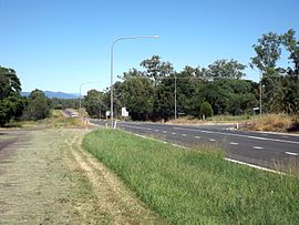 Cunningham Highway, 2015 | |||||||||||||||
 Mutdapilly | |||||||||||||||
| Coordinates | 27°45′55″S 152°38′32″E / 27.7652°S 152.6422°ECoordinates: 27°45′55″S 152°38′32″E / 27.7652°S 152.6422°E | ||||||||||||||
| Population | 308 (2016 census)[1] | ||||||||||||||
| • Density | 7.032/km2 (18.21/sq mi) | ||||||||||||||
| Established | 1827 | ||||||||||||||
| Postcode(s) | 4307 | ||||||||||||||
| Area | 43.8 km2 (16.9 sq mi) | ||||||||||||||
| Time zone | AEST (UTC+10:00) | ||||||||||||||
| Location |
| ||||||||||||||
| LGA(s) |
| ||||||||||||||
| State electorate(s) | Scenic Rim | ||||||||||||||
| Federal division(s) | |||||||||||||||
| |||||||||||||||

Mutdapilly is a rural locality in south-east Queensland, Australia. It is split between the local government areas of Scenic Rim Region and City of Ipswich.[2][3] In the 2016 census Mutdapilly had a population of 308 people.[1]
Geography[]
Mutdapilly is centrally divided by the north/south running Cunningham Highway. The eastern boundary follows Warrill Creek.
There is one of fifteen air quality monitoring stations in the region located at Mutdapilly.[4]
History[]
The name Mutdapilly is believed to be a combination word from the Yuggera language (Yugarabul dialect) where mudtherri means sticky or muddy and pilly means gully.[3][2] The name was given by Captain Patrick Logan on 9 June 1827.[5]
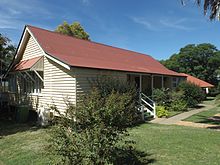
Local farmer, Mr Denman, donated 2 acres of land to build a school. The Normanby State School and teacher's residence was opened on 27 April 1874; the first head teacher was John Stanfell Clowes who served at the school until 31 July 1876. The school was renamed Mutdapilly State School on 1 April 1968.[6][7][8]
St Aidan's Church of England was built in Mutdapilly in 1921, designed by Charles Chauvel (the Australian filmmaker). It was dedicated on 15 April 1922 by Coadjutor Bishop Henry Le Fanu. The church closed in 1974 and the building is now used as a residence.[8][9][10]
In the 2016 census Mutdapilly had a population of 308 people.[1]
Education[]
Mutdapilly State School is a government primary (Prep-6) school for boys and girls at 4 Mutdapilly-Churchbank Weir Road (27°46′16″S 152°39′02″E / 27.7710°S 152.6506°E).[11][12] In 2018, the school had an enrolment of 29 students with 6 teachers (3 full-time equivalent) and 5 non-teaching staff (3 full-time equivalent).[13]
There are no secondary schools in Mutdapilly. The nearest secondary schools are Rosewood State High School in Rosewood to the north-west and Bremer State High School in Ipswich to the north-east.[14]
Heritage listings[]
Heritage listings for Mutdapilly include:
- 4 Mutdapilly-Churchbank Weir Road: Mutdapilly State School[15]
Notable residents[]
- Charles Chauvel, early Australian filmmaker
References[]
- ^ a b c Australian Bureau of Statistics (27 June 2017). "Mutdapilly (SSC)". 2016 Census QuickStats. Retrieved 20 October 2018.

- ^ a b "Mutdapilly (Scenic Rim Regional Council) (entry 45212)". Queensland Place Names. Queensland Government. Retrieved 27 February 2014.
- ^ a b "Mutdapilly (Ipswich City) (entry 46553)". Queensland Place Names. Queensland Government. Retrieved 27 February 2014.
- ^ "South East Queensland". Air monitoring network stations. The State of Queensland. 9 May 2014. Retrieved 16 April 2015.
- ^ "Indigenous Place Names" (PDF). Ipswich City Council. Retrieved 9 April 2015.
- ^ "Opening and closing dates of Queensland Schools". Queensland Government. Retrieved 18 April 2019.
- ^ "Agency ID 152, Mutdapilly State School". Queensland State Archives. Retrieved 27 February 2014.
- ^ a b "Harrisville & District" (PDF). Ipswich City Council. Archived from the original (PDF) on 6 April 2011. Retrieved 27 February 2014.
- ^ Starr, Joan (1988), Moreton Shire Queensland : discovery and settlement, Southern Cross PR and Press Services, ISBN 978-0-9588021-0-9
- ^ "Closed Anglican Churches". Anglican Church South Queensland. Archived from the original on 3 April 2019. Retrieved 29 June 2020.
- ^ "State and non-state school details". Queensland Government. 9 July 2018. Archived from the original on 21 November 2018. Retrieved 21 November 2018.
- ^ "Mutdapilly State School". Retrieved 21 November 2018.
- ^ "ACARA School Profile 2018". Australian Curriculum, Assessment and Reporting Authority. Retrieved 28 January 2020.
- ^ "Queensland Globe". State of Queensland. Retrieved 19 January 2021.
- ^ "Mutdapilly State School (entry 602840)". Queensland Heritage Register. Queensland Heritage Council. Retrieved 17 December 2017.
Further reading[]
- Starr, Joan (1988), Moreton Shire Queensland : discovery and settlement, Southern Cross PR and Press Services, ISBN 978-0-9588021-0-9
External links[]
![]() Media related to Mutdapilly, Queensland at Wikimedia Commons}
Media related to Mutdapilly, Queensland at Wikimedia Commons}
- City of Ipswich
- Scenic Rim Region
- Populated places established in 1827
- 1827 establishments in Australia
- Localities in Queensland