Castlemaine, Victoria
| Castlemaine Victoria | |||||||||
|---|---|---|---|---|---|---|---|---|---|
    Generic Castlemaine building, Post Office, Town Hall and the Castlemaine Uniting Church | |||||||||
 Castlemaine | |||||||||
| Coordinates | 37°3′49″S 144°13′2″E / 37.06361°S 144.21722°ECoordinates: 37°3′49″S 144°13′2″E / 37.06361°S 144.21722°E | ||||||||
| Population | 6,757 (2016 census)[1] | ||||||||
| Established | 1851 | ||||||||
| Postcode(s) | 3450 | ||||||||
| Elevation | 310.9 m (1,020 ft) | ||||||||
| Time zone | AEST (UTC+10) | ||||||||
| • Summer (DST) | AEST (UTC+11) | ||||||||
| Location |
| ||||||||
| LGA(s) | Shire of Mount Alexander | ||||||||
| State electorate(s) | Bendigo West, Northern Victoria | ||||||||
| Federal Division(s) | Bendigo | ||||||||
| |||||||||

Castlemaine (/ˈkæsəlmeɪn/ KASS-əl-mayn,[2] non-locally also /ˈkɑːs-/ KAHSS-) is a small city in Victoria, Australia, in the Goldfields region about 120 kilometres (75 miles) northwest by road from Melbourne and about 40 kilometres (25 miles) from the major provincial centre of Bendigo. It is the administrative and economic centre of the Shire of Mount Alexander. The population at the 2016 Census was 6,757.[1] Castlemaine was named by the chief goldfield commissioner, Captain W. Wright, in honour of his Irish uncle, Viscount Castlemaine.
Castlemaine began as a gold rush boomtown in 1851 and developed into a major regional centre, being officially proclaimed a City on 4 December 1965, although since declining in population.[3]
It is home to many cultural institutions including the Theatre Royal, the oldest continuously operating theatre in mainland Australia.
History[]
Castlemaine exists on the traditional lands of the Dja Dja Wurrung people, also known as the Jaara people. They were regarded by other tribes as being a superior people, not only because of their rich hunting grounds but because from their area came a greenstone rock for their stone axes. Early Europeans described the Dja Dja Wurrung as a strong, physically well-developed people and not belligerent. The Jaara people have a rich culture and reverence for the land.[4]
The first European settlers named it Forest Creek and as the population grew it became known as Mount Alexander. The old name is still present in some place names in Victoria including the Shire of Mount Alexander and the former main road leading to it from Melbourne – Mount Alexander Road. Major Mitchell passed through the region in 1836. Following his discovery, the first squatters arrived in 1837 to establish vast sheep runs.
In 1854, Chief goldfields commissioner, Captain W. Wright, renamed the settlement 'Castlemaine' in honour of his Irish uncle, Viscount Castlemaine.
Discovery of gold[]
On 20 July 1851 gold was discovered near present-day Castlemaine (Mt Alexander Goldfields) at Specimen Gully on Barkers Creek. The gold was discovered by Christopher Thomas Peters, a shepherd and hut-keeper on the Barker's Creek, in the service of Dr William Barker on his Mount Alexander run. When the gold was shown in the men's quarters, Peters was ridiculed for finding fool's gold, and the gold was thrown away. Barker did not want his workmen to abandon his sheep, but in August they did just that. John Worley, George Robinson and Robert Keen, also in the employ of Barker as shepherds and a bullock driver, immediately teamed with Peters in working the deposits by panning in Specimen Gully where the gold had been found, which they did in relative privacy during the next month. When Barker sacked them and ran them off his land for trespass, Worley, on behalf of the party "to prevent them getting in trouble", mailed a letter to The Argus (Melbourne) dated 1 September 1851 announcing this new goldfield with the precise location of their workings. This letter was published on 8 September 1851.[5] "With this obscure notice, rendered still more so by the journalist as 'Western Port', were ushered to the world the inexhaustible treasures of Mount Alexander"[6] also to become known as the Forest Creek diggings. Within a month there were about 8,000 diggers working the alluvial beds of the creeks near the present day town of Castlemaine, and particularly Forest Creek which runs through Chewton where the first small village was established. By the end of the year there were about 25,000 on the field.[7][8]
Gold rush: a city develops[]


The first small village developed at Chewton, today in effect a suburb of Mount Alexander Shire, which included the Commissioner's tent, stores, an office for The Argus newspaper, and an office for the Mount Alexander goldfields' own newspaper the Daily Mail.
On 28 January 1852, William Henry Wright was one of nearly 200 men who were assigned or affirmed as Territorial Magistrates for Victoria. Not long after, he took control of the Mount Alexander diggings and set up a government camp[9] on Forest Street near the junction of Barker and Forest Creeks (today's Camp Reserve). This was to be the new township of Castlemaine. The first reference in a newspaper to the township is found in the Geelong Advertiser of 13 March 1852 with the following notice:
- "- The Lieutenant Governor has appointed John Fletcher, Esq., J.P., to be Police Magistrate at Castlemaine; but where Castlemaine is situate[d] we cannot tell."[10]
A court house was established on what is today known as Goldsmith Crescent, Castlemaine near the new government camp. Stores were also established nearby.
The first official Post Office at Castlemaine, named "Forrest Creek", opened on 1 March 1852. (Renamed the Castlemaine Post Office on 1 January 1854.)[11] The first official Post Office was established after "The Argus" (Melbourne) correspondent at Forest Creek had an article published in November 1851 that put the case forward for a Post Office to be established somewhere between the Forest Creek goldfield and Kyneton. At the same time (November 1851) he described the Forest Creek diggings as having many businesses such as stores and licensed hawkers and "at least 8000 persons on the two creeks (Forest and Barker)".[12] The need pointed out in "The Argus" in November 1851 had resulted in an unofficial Post Office being established on the diggings at Chewton (Forest Creek) in December 1851, a Post Office then described as being "on the most central part of the diggings".[13]
On 15 February 1853 town lots were offered for sale. By that time the first Castlemaine District Hospital had been opened, the gaol had been built, and Castlemaine was moving from 'tent' town to bricks and mortar.[9]
A local government was formed on 23 April 1855 and was later to become the Town of Castlemaine and in 1965 became the City of Castlemaine.[14] However, with municipal amalgamations in the early 1990s, Castlemaine lost its 'City' status and is now simply the largest town in the Shire.
The Theatre Royal opened in 1856 to provide entertainment for the gold diggers, with a notable performance being provided by the world-renowned Lola Montes and her celebrated Spider Dance. It remains mainland Australia's continuously operating theatre.
In 1859, the historic Castlemaine Football Club was established. Evidence makes it the second oldest football club in Australia and one of the oldest football clubs in the world.
After the gold rush[]

Before 1880 the residences numbered over 2000, and there was a population in the township of 7,500.[9]
As gold mining gradually ceased a number of other secondary industries sprang up. These included breweries, iron foundries and a woollen mill. Thompson's Foundry (now trading as Flowserve) was one of Castlemaine's largest employers.
From the 1970s the industries that had dominated employment in the town for a century began to decline, with many factories closing and others such as Thompson's Foundry significantly downsizing. This led to the displacement of large numbers of people, with many families leaving in search of jobs elsewhere. The area's precious goldrush history and heritage was, however, increasingly recognised, along with its notable population of arts practitioners. Substantial planning and activity helped create new industries in heritage tourism, arts tourism, nature tourism and so on. As a result, Castlemaine began to be visited – and settled – by more 'outsiders', primarily from Melbourne.
Some of these more recent arrivals added to the gentrification of the Victorian era town, helping to preserve its already charming country aspect and enhancing it by establishing a number of cafes and restaurants. As with much gentrification, however, consequent rising house prices placed increased economic pressure on many earlier inhabitants who sometimes struggle to continue living in the area.
The town has, overall, taken on a fresh lease of life, combining some of the more desirable aspects of urban Melbourne with the charm and openness of old Castlemaine.
Geography[]
Castlemaine is nestled in a valley. The urban area extends to several suburban areas, north toward Barkers Creek, west to , east to and Chewton and south to Campbells Creek.
Climate[]
| hideClimate data for Castlemaine, Victoria, Australia | |||||||||||||
|---|---|---|---|---|---|---|---|---|---|---|---|---|---|
| Month | Jan | Feb | Mar | Apr | May | Jun | Jul | Aug | Sep | Oct | Nov | Dec | Year |
| Average high °C (°F) | 28.0 (82.4) |
28.3 (82.9) |
24.9 (76.8) |
20.0 (68.0) |
15.5 (59.9) |
12.5 (54.5) |
11.7 (53.1) |
13.2 (55.8) |
15.6 (60.1) |
19.2 (66.6) |
22.5 (72.5) |
25.5 (77.9) |
19.7 (67.5) |
| Daily mean °C (°F) | 20.3 (68.5) |
20.6 (69.1) |
18.0 (64.4) |
14.0 (57.2) |
10.5 (50.9) |
7.9 (46.2) |
7.2 (45.0) |
8.4 (47.1) |
10.3 (50.5) |
13.0 (55.4) |
15.7 (60.3) |
18.1 (64.6) |
13.7 (56.6) |
| Average low °C (°F) | 12.6 (54.7) |
13.0 (55.4) |
11.1 (52.0) |
8.0 (46.4) |
5.6 (42.1) |
3.4 (38.1) |
2.7 (36.9) |
3.7 (38.7) |
5.0 (41.0) |
6.8 (44.2) |
8.9 (48.0) |
10.8 (51.4) |
7.6 (45.7) |
| Average precipitation mm (inches) | 37 (1.5) |
33 (1.3) |
36 (1.4) |
47 (1.9) |
62 (2.4) |
54 (2.1) |
61 (2.4) |
71 (2.8) |
62 (2.4) |
62 (2.4) |
42 (1.7) |
42 (1.7) |
609 (24) |
| Source: Castlemaine Climate[15] | |||||||||||||
Governance[]

In local government, the Castlemaine region is covered by the Shire of Mount Alexander. The council was created in 1995 as an amalgamation of a number of other municipalities in the region with the Council and Civic Centre in the former School of Mines, in central Castlemaine, next to the original Town Hall. Castlemaine Town is represented by the Castlemaine Ward. The Loddon River Ward is centered around the township of Newstead. The Tarrengower Ward is centered around the township of Maldon. The Calder Ward is centred around Harcourt. The Coliban Ward covers the villages of Chewton, Elphinstone and Taradale.
In state politics, Castlemaine is located in the Legislative Assembly districts of Bendigo West currently held by the Australian Labor Party.[16]
In federal politics, Castlemaine is located in a single House of Representatives division – the Division of Bendigo. The Division of Bendigo has been an Australian Labor Party seat since 1998.
Economy[]
Castlemaine's largest industry is in manufacturing, particularly food manufacturing.
The biggest employer is KR Castlemaine (formerly the Castlemaine Bacon Company, established 1905), producing smallgoods with over 900 employees.[17]
Cultural and heritage tourism is another large industry in Castlemaine, with the historic art gallery being a major drawcard.
Castlemaine has recently joined the likes of nearby Daylesford with gaining tourism from Melbourne, offering an array of local cafes and bars which have increased the region's appeal.
Heritage[]

Barker Street was named after William Barker, another pioneer pastoralist whose run included part of the land which is now Castlemaine. The whole eastern side of Barker Street, between Templeton Street and Lyttleton Street, has been classified by the National Trust. Adjacent to the solicitors' offices is the library, built in 1857 as a mechanics' institute with additions in 1861, 1872 and 1893. Next to it is the Faulder Watson Hall which opened in 1895 and adjacent is the old telegraph office (1857). On the Lyttleton Street corner is the decorative Classical Revival post office (1873–75). It is in the form of an Italian palazzo with a central clock tower, five arched bays and strongly contrasting colouration. This structure replaced a wooden post office which was built on this same spot in 1859 when the service was transferred from the gold commissioner's camp. Over the road is the Cumberland Hotel (1884).[18]
Parks and open space[]
Castlemaine has its own botanical gardens, established in 1860, which are on the Victorian Heritage Register.[19] The gardens feature Lake Joanna (an artificial lake), many exotic tree species and structures dating to the Victorian era. The Castlemaine public swimming pool is 50m in length and is located next to the botanical gardens.
The Castlemaine Diggings National Heritage Park is the first of its kind in Australia. It embraces gold rush relics and bushland. Home to rare and threatened species of both flora and fauna it offers opportunities for bush walking, bird watching, wildlife monitoring and study while providing a bush setting for the township.[20]
Castlemaine Art Museum[]

Founded in 1913, the Castlemaine Art Museum has acquired a collection of Australian art works and historical items from the district's past. The 1931 art deco building designed by Percy Meldrum is noted for its elegant design and is heritage listed. The building has been extended a number of times.[21]
The gallery has always specialised in Australian art.[22] Its particular strength is in major works of the late 19th century and the Edwardian era. Traditional landscape painting is a feature of the collection. Contemporary artists are also well represented.
Earlier artists include Louis Buvelot, Fred McCubbin, Tom Roberts, Arthur Streeton, Violet Teague, May Vale, Walter Withers, David Davies, Rupert Bunny, Max Meldrum, John Russell, Hugh Ramsay, Clarice Beckett, A.M.E. Bale, Arthur Lindsay and John Longstaff.
Modernists include Margaret Preston, Roland Wakelin, Russell Drysdale, Fred Williams, John Brack, Albert Tucker, John Perceval, Clifton Pugh, Lloyd Rees and Roger Kemp. More contemporary painters include Rick Amor, , Ray Crooke, Peter Benjamin Graham, Robert Jacks, Jeffrey Smart, Ian Armstrong, and Brian Dunlop. The gallery collects photographic images of Australian artists by Australian photographers and has built up a collection by photographers as Max Dupain, David Moore, Richard Beck and Olive Cotton.
The museum houses a collection of historical artworks, journals, photographs, costumes and items specifically relating to the history of the Mount Alexander district.
Copies of about a dozen examples of the work of Christian Waller (née Yandell) are available in the museum, which also holds photographs and information related to other members of the Yandell family, who were among the notable founding residents of the town of Castlemaine. One of the most prominent Yandells was Augustus Courts Yandell, whose success as a gold-finder in the 1850s enabled him and his family to own as many as 15 Castlemaine properties at one time. One example is the house at 14 Doveton Street, dating from 1858.[23]
The museum was due to close on 11 August 2017 due to lack of funds, but was saved by a donation of $250,000 by an anonymous couple and local fundraising efforts.[24]
Culture, community and sport[]
The Theatre Royal claims to be the oldest continuously operating theatre in mainland Australia. It hosts films (including several world and Australian premieres), concerts and functions.
Castlemaine Farmers Market[]
Castlemaine also hosts a local farmers market where the finest producers of the Mount Alexander Shire region, all in one place. The market is currently held on the Western Reserve, Forest Street, Castlemaine[25]
Buda Historic Home and Garden[]
See Buda Historic Home and Garden
Wesley Hill Community Market[]
The Wesley Hill Community Market operates every Saturday from 9a.m. to 2 p.m. It is located at 149 Pyrenees Highway, Castlemaine, and has over 70 stalls selling a range of merchandise, local products and farmers' products.
Castlemaine State Festival[]
Since 1974, Castlemaine has biennially been the home of the Castlemaine State Festival. Running for ten days, this festival is one of Victoria's most notable regional arts events. The festival, now usually held in late March, offers many events with a particular emphasis on visual arts, music and theatre. It has also attracted internationally and nationally renowned performers, including the Melbourne Symphony Orchestra. The most recent festival was held on 19 March to 4 April 2021.[26]
Run the Maine[]
Held annually in October, Run the Maine is a fun run event around the Castlemaine Botanical Gardens which raises funds for the local hospital – Castlemaine Health. Participants can choose to run 5.5 km, 11 km or a 14 km trail run. The 2020 event was run virtually, with runners uploading their times individually due to COVID-19.[27]
Sport[]
Australian rules football is popular, with the Castlemaine Football Club competing in the Bendigo Football League.[28] The club is acknowledged as being the second oldest in Australia.[citation needed]
On Wesley Hill, just out of Castlemaine, is the Castlemaine sporting complex, which hosts a range of sport including basketball, netball, badminton and cycling. Castlemaine Tennis Club on Wheeler Street next to Forest Creek features four plexipave courts and eight further synthetic grass courts. Castlemaine has many cricket teams in the town itself and the surrounding area. It is also renowned for its mountain bike trails, with a reputedly world-class, newly-developed multi trail walking and cycling facility on the slopes of Mount Alexander at nearly Harcourt. Two golf courses are available; at the Castlemaine Golf Club in the bordering Muckleford region on Newstead Road,[29] and at the course of the Mount Alexander Golf Club on Wimble Street.[30]
Castlemaine is also the self-proclaimed Hot Rod centre of Australia with many small businesses catering to this popular form of motor sport at a national level. Examples of the cars can be seen on show days and rod runs throughout the year. There are plans for a permanent Hot Rod centre.
Churches[]
As a gold rush town, Castlemaine attracted migrants from all over the world. So in addition to 'established' churches such as the Anglicans, Presbyterians and Roman Catholics, arrivals in the district included Methodists, Baptists and Congregationalists from mining areas in provincial Britain where nonconformist churches were more popular, as well as Lutherans from continental Europe. Initially the churches in Victoria were unable to cope with huge numbers of migrants settling in areas which had been sparsely populated.[31] However a few proactive clergymen set out for the diggings where they were assisted by lay preachers amongst the diggers. Initially they preached in tents and from tree stumps but by 1853 the first rough churches had been built.
There was also a sizeable Chinese population with concomitant Joss Houses and Temples; besides a few artifacts, no structures remain.
Churches to have operated in Castlemaine in order of establishment are:
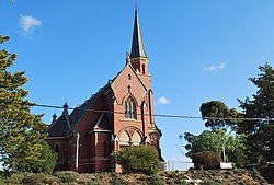
- Methodist. 1850s – 1977 when they merged to become the Uniting Church of Australia.
- Anglican. 1850s – present.
- Roman Catholic. 1853–present.
- Presbyterian. 1850s – 1977 and 1984 – present. The Castlemaine congregation merged with the Uniting Church in 1977, but some members later broke away to reestablish that denomination in the town.
- Baptist. 1861? – present.
- Congregational. 1800s – 1977 when they merged to become part of the Uniting Church.
- Church of Christ. 1800s – present.
- Lutheran. 1800s to present.
- Salvation Army. Late 1800s to present.
- Seventh Day Adventist.
- Uniting Church. 1977–present. Absorbed the local Methodist, Presbyterian and Congregational churches, although some Presbyterians broke away in 1984 to reestablish a Presbyterian presence in the town.
- Pentecostal: Grace Church, Liberty Christian Life Centre in Campbell Creek (affiliated with Assemblies of God).
The Uniting Church was created in 1977 and the local Methodist, Presbyterian and Congregational congregations chose to join. Since the Presbyterians had the largest church building, the best hall and largest grounds, the merged denominations met there. The Methodist and Congregational buildings were sold, with the Adventists taking over the former Methodist church and a conservative group that wished to reestablish a distinct Presbyterian service moving into the former Congregational Church building over the road from their original church.
In popular culture[]
Castlemaine XXXX beer and HMAS Castlemaine were named after the city.
The ABC TV series Glitch was partially filmed in Castlemaine, and the fictional town of Yoorana in which the series is set is located on the western side of (and effectively replaces) Castlemaine, per an on-screen map.[citation needed]
Infrastructure[]
Education[]
Primary schools[]
Castlemaine and its outlying areas have eight primary schools catering for prep to year 6 (and beyond for the two independent schools).[32] From north to south they are:
- Castlemaine North Primary School. (Usually known as North School.) No 2051. Opened 1878, successor to a state funded Wesleyan school operating since 1853
- St Mary's School. (Roman Catholic.) Opened 1854, current building completed 1962. Operated by Sisters of Mercy until 1984, the last nuns left in 1988.
- Castlemaine Primary School, (Usually known as South School.) No 119. Opened 1855, present main building completed 1875.
- Winters Flat Primary School. No 652. Opened 1860, current buildings opened 1964.
- Castlemaine Steiner School. (Independent.) Opened on current site as a school in 1996. previously a kindergarten on other sites from 1988.
- Chewton Primary School. No 1054. Opened 1870, present building completed 1911.
- Olivet Christian College, Campbell's Creek. (Independent.) Established 1979.
- Campbell's Creek Primary School. No 120. Opened 1853, present building completed 1878.
Secondary schools[]
The town is served by Castlemaine Secondary College which was created in 1994 by combining the former Castlemaine High School (established 1910) and the Castlemaine Technical College (established in 1887 as the Castlemaine School of Mines). The Junior Campus of the Secondary College was at Milkmaids Flat at the northern end of the town on the old High School site, while the Senior Campus occupied the former Tech College site at Norwood Hill to the south of the town. These campuses have now merged at the former Junior Campus. The Norwood Hill site has been re-purposed as Autoplex Castlemaine (a project of Castlemaine Hot Rod Centre Limited) and as a business incubation project by Workspace Australia.
- St Gabriel's College, a Roman Catholic secondary school operated between 1906 and 1974 on a site adjoining St Marys primary school.[33]
- Castlemaine Grammar School opened prior to 1865 and operated from a building in Hargraves St until 1910.
Health[]
A large hospital and a geriatric care centre (Castlemaine Health, formerly Mount Alexander Hospital) is located on the northern edge of Castlemaine. The former Maldon Hospital is now home to older and frail residents in the Jessie Bowe Centre and Mountview Centre.
The Castlemaine District Community Health Centre provides a range of health services (including a Needle & Syringe Program) and there are several large medical general practices. Primary care options include dentists, opticians, physiotherapists, podiatrists, chiropractors, pathology and hearing services, plus a substantial number of complementary and alternative practitioners.
The Shire has three prisons – HMP Loddon and HMP Middleton for men are located on the eastern outskirts at Wesley Hill, and HMP Tarrengower (outside Maldon) for women.
Transport[]

Castlemaine is at the junction of several main roads including the Pyrenees Highway running west connecting it to Maryborough and east toward Elphinstone, the Midland Highway running north connecting it to Bendigo and south connecting it to Daylesford and Maldon-Castlemaine Road, running north west toward Maldon.
V/Line Rail services operate out of the Castlemaine railway station which is on the Bendigo railway line. V/Line operates VLocity services to Melbourne's Southern Cross station, the fastest weekday express taking 65 minutes. Travel to Bendigo by train takes a minimum of 18 minutes. A V/Line Coach service between Castlemaine and Maryborough also operates out of Castlemaine railway station. The Victorian Goldfields Railway operates a tourist railway, running old steam and diesel engines from Maldon station to Castlemaine via Muckleford.
Castlemaine Bus Lines provides suburban bus services from Castlemaine railway station to Chewton, Campbells Creek, and North Castlemaine as well as Intercity services to Maldon, Elphinstone, and Taradale.
The local taxi service is run by Castlemaine Taxis.
Media[]
The weekly Castlemaine Mail, which began as the Mount Alexander Mail in 1854, became part of The Midland Express group in 1984 and is still produced.[34]
Community radio station MainFM broadcasts from the old Castlemaine Hospital and broadcasts on 94.9FM.
Notable residents[]

- Bud Annand – deceased, former Australian rules footballer with St Kilda
- Hayley Colquhoun, Tia Davidge and Stella Matheson, a Trio of legends from the Maine
- his son, David – a contestant on the third season of the Australian version of The Mole
- Ron Barassi – Australian rules footballer from Guildford within the shire
- Robert O'Hara Burke – leader of the Burke and Wills expedition, stationed in Castlemaine as police superintendent from 1858 to 1859[35]
- Mary Card – crochet designer, born at Castlemaine
- Mary Fairburn – musician and illustrator
- KIAN - singer and songwriter, who won Triple J's Unearthed High in 2018.
- Frank Laver – Test cricketer
- Sir Harry Lawson – Premier of Victoria
- Dustin Martin – Australian rules footballer for Richmond and Brownlow Medallist
- Alex Miller – Miles Franklin Award winning author
- Frank McEncroe – creator of the Chiko Roll
- Steven Oliver – former Carlton footballer and candidate in the 2010 Victorian state election
- Sir James Patterson – Premier of Victoria
- Frank Tate – Victoria's first Director of Education, a position he held for 26 years
- Jack Titus – AFL footballer for Richmond, AFL Hall of Famer and RFC club 'Immortal'
- Robyn Davidson – Adventurer and writer
- Sir Stephen Henry Roberts – historian and Vice Chancellor University of Sydney, attended Castlemaine High School
- Augustus Courts Yandell and several other family members[36] – Castlemaine pioneer and goldfinder, 1850s.
- Ernest Leviny – clock maker, gold/silver smith (1818–1905)
See also[]
- HM Prison Loddon
- Buda Historic Home and Garden
References[]
- ^ Jump up to: a b Australian Bureau of Statistics (27 June 2017). "2016 Community Profiles: Castlemaine (State Suburb)". 2016 Census of Population and Housing. Retrieved 18 April 2018.

- ^ Macquarie Dictionary, Fourth Edition (2005). Melbourne, The Macquarie Library Pty Ltd. ISBN 1-876429-14-3.
- ^ "Castlemaine" in The Age, 15 September 2008
- ^ "Giyakiki | Our Story – Djaara (Dja Dja Wurrung Clans Aboriginal Corporation)". Retrieved 1 June 2021.
- ^ "Domestic Intelligence – New Goldfield". The Argus. Melbourne: National Library of Australia. 8 September 1851. p. 2. Retrieved 5 May 2013.
- ^ "Council paper". The Sydney Morning Herald. National Library of Australia. 28 March 1854. p. 2. Retrieved 5 May 2013.
- ^ http://greengraphics.com.au. "The Monster Meeting » The Story". www.monstermeeting.net. Archived from the original on 26 January 2016. Retrieved 16 May 2017.
- ^ "Ballarat Reform League – Chewton". 6 July 2011. Archived from the original on 8 April 2013. Retrieved 16 May 2017.CS1 maint: bot: original URL status unknown (link)
- ^ Jump up to: a b c State of Victoria Early Postal Cancels (and History) Illustrated, Section II: 1851 to 1853 Archived 2 November 2013 at the Wayback Machine
- ^ "New police magistrate" Geelong Advertiser and Intelligencer (Vic.) 13 March 1852 Page 2
- ^ Premier Postal History, Post Office List, retrieved 11 April 2008
- ^ "Forest Creek Diggings, Mount Alexander". The Argus. Melbourne: National Library of Australia. 12 November 1851. p. 2. Retrieved 5 May 2013.
- ^ "Meeting of the Diggers at Mount Alexander". The Argus. Melbourne: National Library of Australia. 18 December 1851. p. 2. Retrieved 5 May 2013.
- ^ Victorian Municipal Directory, Brunswick: Arnall & Jackson, 1992, p. 332 Accessed at State Library of Victoria, La Trobe Reading Room.
- ^ "Climate Castlemaine". climate-data.org. Retrieved 15 July 2019.
- ^ "State Election 2006 Results: Electorate swings". Victorian Electoral Commission website. Archived from the original on 30 November 2007. Retrieved 16 December 2007.
- ^ Is Don. Is good for Castlemaine Bendigo Advertiser. 31 July 2008
- ^ "Castlemaine". The Sydney Morning Herald. 15 September 2008.
- ^ "VHD". vhd.heritage.vic.gov.au. Retrieved 16 May 2017.
- ^ Castlemaine Diggings National Heritage Park web page, Parks Victoria, December 2010, retrieved 15 January 2012
- ^ "Castlemaine Art Museum – and historical museum". www.castlemainegallery.com. Retrieved 16 May 2017.
- ^ "Collectionsaustralia.net". www.collectionsaustralia.net. Retrieved 16 May 2017.
- ^ Mather, K, 2019, "Comings and goings in my goldfields house", Traces, December 2019, pp. 46–48.
- ^ "Anonymous couple saves Castlemaine Art Museum from closure". 3 August 2017.
- ^ http://castlemainefarmersmarket.org/. Missing or empty
|title=(help) - ^ "Castlemaine State Festival website".
- ^ "Run the Maine website".
- ^ Full Points Footy, Castlemaine, archived from the original on 7 January 2011, retrieved 25 July 2008
- ^ Golf Select, Castlemaine, retrieved 11 May 2009
- ^ Golf Select, Mount Alexander, retrieved 11 May 2009
- ^ Serle, Geoffrey. The golden age: a history of the colony of Victoria 1851 – 1861. M.U.P., 1977. Chapter 12.
- ^ Principal source is R. P. Desmond. A history of the Old Castlemaine Schoolboys Association 1912 – 1990. n.p. n.d.
- ^ http://stmaryscastlemaine.com/school.html
- ^ "Midland express". Trove. 1989. Retrieved 15 February 2015.
- ^ Phoenix, Dave (2011). Following Burke and Wills across Victoria : a touring guide. Phoenix. ISBN 978-0-646-56419-7.
- ^ Mather, K 2019, "Comings and Goings in my Goldfields House", Traces Magazine, December 2019, pp. 46–48.
External links[]
| Wikimedia Commons has media related to Castlemaine, Victoria. |
| Wikivoyage has a travel guide for Castlemaine. |
- Castlemaine Maldon: Visitor Information
- Castlemaine Historical Society
- Art Trails: Castlemaine Art Gallery Historical Museum
- Castlemaine Classifieds
| show Authority control |
|---|
- Mining towns in Victoria (Australia)
- Towns in Victoria (Australia)
- Populated places established in 1851
- 1851 establishments in Australia