Chambles
Chambles | |
|---|---|
Commune | |
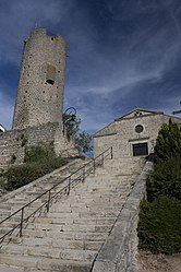 Tower and staircase | |
 Coat of arms | |
show Location of Chambles | |
 Chambles | |
| Coordinates: 45°26′34″N 4°14′20″E / 45.4428°N 4.2389°ECoordinates: 45°26′34″N 4°14′20″E / 45.4428°N 4.2389°E | |
| Country | France |
| Region | Auvergne-Rhône-Alpes |
| Department | Loire |
| Arrondissement | Montbrison |
| Canton | Saint-Just-Saint-Rambert |
| Intercommunality | CA Loire Forez |
| Government | |
| • Mayor (2020–2026) | Pierre Giraud[1] |
| Area 1 | 18.9 km2 (7.3 sq mi) |
| Population (Jan. 2018)[2] | 1,018 |
| • Density | 54/km2 (140/sq mi) |
| Time zone | UTC+01:00 (CET) |
| • Summer (DST) | UTC+02:00 (CEST) |
| INSEE/Postal code | 42042 /42170 |
| Elevation | 360–741 m (1,181–2,431 ft) (avg. 640 m or 2,100 ft) |
| 1 French Land Register data, which excludes lakes, ponds, glaciers > 1 km2 (0.386 sq mi or 247 acres) and river estuaries. | |


Chambles (French pronunciation: [ʃɑ̃bl]) is a commune in the Loire department in central France.
Population[]
|
|
See also[]
References[]
- ^ "Répertoire national des élus: les maires". data.gouv.fr, Plateforme ouverte des données publiques françaises (in French). 2 December 2020.
- ^ "Populations légales 2018". INSEE. 28 December 2020.
| Wikimedia Commons has media related to Chambles. |
This Loire geographical article is a stub. You can help Wikipedia by . |
Categories:
- Communes of Loire (department)
- Segusiavi
- Loire geography stubs