La Pacaudière
La Pacaudière | |
|---|---|
Commune | |
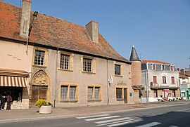 Hôtel des Impôts | |
 Coat of arms | |
show Location of La Pacaudière | |
 La Pacaudière | |
| Coordinates: 46°10′34″N 3°52′05″E / 46.1761°N 3.8681°ECoordinates: 46°10′34″N 3°52′05″E / 46.1761°N 3.8681°E | |
| Country | France |
| Region | Auvergne-Rhône-Alpes |
| Department | Loire |
| Arrondissement | Roanne |
| Canton | Renaison |
| Intercommunality | Roannais Agglomération |
| Government | |
| • Mayor (2014–2020) | Georges Dru |
| Area 1 | 20.61 km2 (7.96 sq mi) |
| Population (Jan. 2018)[1] | 1,063 |
| • Density | 52/km2 (130/sq mi) |
| Time zone | UTC+01:00 (CET) |
| • Summer (DST) | UTC+02:00 (CEST) |
| INSEE/Postal code | 42163 /42310 |
| Elevation | 295–443 m (968–1,453 ft) (avg. 363 m or 1,191 ft) |
| 1 French Land Register data, which excludes lakes, ponds, glaciers > 1 km2 (0.386 sq mi or 247 acres) and river estuaries. | |


La Pacaudière is a commune in the Loire department in central France.
Population[]
|
|
See also[]
References[]
- ^ "Populations légales 2018". INSEE. 28 December 2020.
| Wikimedia Commons has media related to La Pacaudière. |
This Loire geographical article is a stub. You can help Wikipedia by . |
Categories:
- Communes of Loire (department)
- Loire geography stubs