La Tour-en-Jarez
La Tour-en-Jarez | |
|---|---|
Commune | |
 | |
show Location of La Tour-en-Jarez | |
 La Tour-en-Jarez | |
| Coordinates: 45°29′09″N 4°23′21″E / 45.4858°N 4.3892°ECoordinates: 45°29′09″N 4°23′21″E / 45.4858°N 4.3892°E | |
| Country | France |
| Region | Auvergne-Rhône-Alpes |
| Department | Loire |
| Arrondissement | Saint-Étienne |
| Canton | Sorbiers |
| Intercommunality | Saint-Étienne Métropole |
| Government | |
| • Mayor (2014–2020) | Roland Goujon |
| Area 1 | 5.05 km2 (1.95 sq mi) |
| Population (Jan. 2018)[1] | 1,476 |
| • Density | 290/km2 (760/sq mi) |
| Time zone | UTC+01:00 (CET) |
| • Summer (DST) | UTC+02:00 (CEST) |
| INSEE/Postal code | 42311 /42580 |
| Elevation | 453–698 m (1,486–2,290 ft) (avg. 540 m or 1,770 ft) |
| 1 French Land Register data, which excludes lakes, ponds, glaciers > 1 km2 (0.386 sq mi or 247 acres) and river estuaries. | |


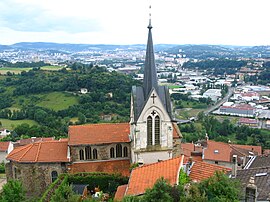
La Tour-en-Jarez is a commune in the Loire department in central France.
Population[]
|
|
Twin towns[]
La Tour-en-Jarez is twinned with:
 Vörstetten, Germany
See also[]
References[]
- ^ "Populations légales 2018". INSEE. 28 December 2020.
| Wikimedia Commons has media related to La Tour-en-Jarez. |
This Loire geographical article is a stub. You can help Wikipedia by . |
Categories:
- Communes of Loire (department)
- Loire geography stubs