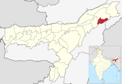
Charaideo district
Charaideo district | |
|---|---|
 Maidam of Ahom Kings | |
 | |
| Country | |
| State | Assam |
| Division | Upper Assam |
| Headquarters | Sonari |
| Government | |
| • Lok Sabha constituencies | Jorhat |
| • Vidhan Sabha constituencies | Mahmara, Sonari |
| Area | |
| • Total | 1,069 km2 (413 sq mi) |
| Population | |
| • Total | 471,418 |
| • Density | 440/km2 (1,100/sq mi) |
| Languages | |
| • Official | Assamese |
| Time zone | UTC+5:30 (IST) |
| Vehicle registration | AS 33 |
| Website | charaideo |
Charaideo district is an administrative district in the state of Assam in India. It was formally declared a new district of the state on 15 August 2015 by then Chief Minister of Assam Tarun Gogoi.[1] It has been carved out of Sivasagar district with Sonari as its administrative headquarter. It comes under Upper Assam division.[2][3][4]
Etymology[]
Charaideo was established by the first Ahom king Chaolung Sukaphaa.[5] The name Charaideo originated from Tai-Ahom word Che Rai Doi or Doi Che Rai which means the shining city on the hills. The Che-Rai-Doi Assamised into Charaideo or Charai-khorong.[6][7]
History[]
Before the arrival of Sukaphaa the place was a place of worship for local tribes like Morans, Borahis and Chutias.[8]
The site of Charaideo was the capital of the Ahom kingdom established by the first Ahom king Chao Lung Siu-Ka-Pha in 1253. The Maidams (tumulus) of the Ahom kings and queens at Charaideo hillocks resemble the shape of small pyramids. The site has had some archaeological works but also has suffered from robbers.[9] There have been calls for the site to be UNESCO World Heritage listed.[10]
Demographics[]
The district has a population of 4,71,418.[11]
Notable people[]
- Suresh Ranjan Goduka, Assamese poet and mass communicator
See also[]
Notes[]
- ^ Assam gets five more districts
- ^ Charaideo commonly known as pyramids of Assam
- ^ reparations afoot for inauguration of Charaideo district at Sonari
- ^ Palasbari incensed over choice of district HQ
- ^ Gogoi, Padmeswar (1968). The Tai and the Tai kingdoms: with a fuller treatment of the Tai-Ahom kingdom in the Brahmaputra Valley. Dept. of Publication, Gauhati University. pp. 264 & 265.
- ^ Gohain, Birendra Kr (1999). Origin of the Tai and Chao Lung Hsukapha: A Historical Perspective. Omsons Publications. pp. 72 & 73.
- ^ Bezbaruah, Ranju; Banerjee, Dipankar; Research, Indian Council of Historical (2008). North-East India: interpreting the sources of its history. Indian Council of Historical Research. p. 117. ISBN 9788173052958.
- ^ (Dutta 1985:50)
- ^ Dutta, Pullock; Das, Ripunjoy (2003-03-01). "Bounty hunters beat ASI to tombs". The Telegraph. Calcutta, India. Retrieved 2007-12-06.
- ^ Das, Ripunjoy (2006-01-19). "Saving Ahom kingdom - Local youths push for Unesco tag to protect Charaideo". The Telegraph. Calcutta, India. Retrieved 2007-12-06.
- ^ "Charaideo at a glance | Charaideo District | Government Of Assam, India". charaideo.gov.in. Retrieved 2020-11-09.
References[]
- Dutta, Sristidhar (1985), The Mataks and their Kingdom, Allahabad: Chugh Publications
External links[]
Coordinates: 26°55′59″N 94°44′53″E / 26.933°N 94.7481°E

- Charaideo district
- Districts of Assam
- 2015 establishments in Assam
- Ahom kingdom