Charlier (Martian crater)
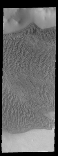 THEMIS image of Charlier crater showing part of the large sand sheet with surface dune forms on the crater floor | |
| Planet | Mars |
|---|---|
| Region | Mare Australe quadrangle |
| Coordinates | 68°34′S 168°40′W / 68.56°S 168.67°WCoordinates: 68°34′S 168°40′W / 68.56°S 168.67°W |
| Quadrangle | Mare Australe |
| Diameter | 106.28 km |
| Discoverer | Mariner 9 |
| Eponym | Carl V. Charlier, Swedish astronomer |

Charlier is a crater in the Mare Australe quadrangle of Mars. The crater is located at 68.56°S latitude and 168.67°W longitude. It is 106.28 km in diameter and was named after Carl Charlier, a Swedish astronomer. Its name was approved in 1973.[1]

This topographic map was created using Mars Orbiter Laser Altimeter (MOLA) technology on the Mars Global Surveyor spacecraft. This image is a screenshot of RedMapper's website and shows the north rim of Charlier crater.

This topographic map was created using Mars Orbiter Laser Altimeter (MOLA) technology on the Mars Global Surveyor spacecraft. This image is a screenshot of RedMapper's website and shows the south rim of Charlier crater.
See also[]
- List of craters on Mars: A-G
References[]
- ^ "Charlier". Gazetteer of Planetary Nomenclature (USGS). International Astronomical Union. Retrieved April 26, 2018.
External links[]
 Media related to Charlier (crater) at Wikimedia Commons
This article about an extraterrestrial geological feature is a stub. You can help Wikipedia by . |
This article about the planet Mars or its moons is a stub. You can help Wikipedia by . |
Categories:
- Mare Australe quadrangle
- Impact craters on Mars
- Astrogeology stubs
- Mars stubs