Chodská Lhota
Chodská Lhota | |
|---|---|
Municipality | |
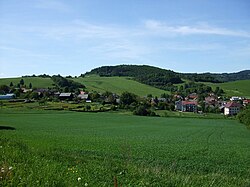 General view of the village | |
 Flag  Coat of arms | |
 Chodská Lhota | |
| Coordinates: 49°20′54″N 13°4′49″E / 49.34833°N 13.08028°ECoordinates: 49°20′54″N 13°4′49″E / 49.34833°N 13.08028°E | |
| Country | |
| Region | Plzeň |
| District | Domažlice |
| Area | |
| • Total | 10.27 km2 (3.97 sq mi) |
| Elevation | 500 m (1,600 ft) |
| Population (2011) | |
| • Total | 433 |
| • Density | 42/km2 (110/sq mi) |
| Postal code | 345 10 |
| Website | http://www.chodskalhota.cz |

Chodská Lhota (until 1946 Lhota, German: Melhut) is a village and municipality (obec) in Domažlice District in the Plzeň Region of the Czech Republic.
The municipality covers an area of 10.27 square kilometres (3.97 sq mi), and has a population of 406 (as of 28 August 2006).
Chodská Lhota lies approximately 16 kilometres (10 mi) south-east of Domažlice, 50 km (31 mi) south-west of Plzeň, and 127 km (79 mi) south-west of Prague.
Gallery[]

Monument
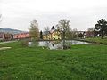
Water tank

Pub


References[]
| Wikimedia Commons has media related to Chodská Lhota. |
| Authority control: National libraries |
|---|
This Plzeň Region location article is a stub. You can help Wikipedia by . |
Categories:
- Villages in Domažlice District
- Chodové
- Bohemian Forest
- Plzeň Region geography stubs