Rybník (Domažlice District)
Rybník | |
|---|---|
Municipality | |
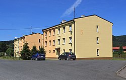 Houses in the village | |
 Rybník | |
| Coordinates: 49°30′58″N 12°40′34″E / 49.51611°N 12.67611°ECoordinates: 49°30′58″N 12°40′34″E / 49.51611°N 12.67611°E | |
| Country | |
| Region | Plzeň |
| District | Domažlice |
| Area | |
| • Total | 36.53 km2 (14.10 sq mi) |
| Elevation | 532 m (1,745 ft) |
| Population (2019) | |
| • Total | 188 |
| • Density | 5.1/km2 (13/sq mi) |
| Postal code | 345 25 |

Rybník (German: Waier) is a village and municipality (obec) in Domažlice District in the Plzeň Region of the Czech Republic. It lies in the Radbuza River valley in the Upper Palatine Forest.
The municipality covers an area of 36.53 square kilometres (14.10 sq mi), and has a population of 188 (as of 1 January 2019).[1]
Rybník lies approximately 21 kilometres (13 mi) north-west of Domažlice, 57 km (35 mi) south-west of Plzeň, and 141 km (88 mi) south-west of Prague.
References[]
- ^ "Customized selection VDB". vdb.czso.cz. Retrieved 2020-03-29.
| Wikimedia Commons has media related to Rybník (Domažlice District). |
| Authority control: National libraries |
|---|
This Plzeň Region location article is a stub. You can help Wikipedia by . |
Categories:
- Villages in Domažlice District
- Plzeň Region geography stubs