Horšovský Týn
Horšovský Týn | |
|---|---|
 General view of the town | |
 Flag  Coat of arms | |
 Horšovský Týn Location in the Czech Republic | |
| Coordinates: 49°31′47″N 12°56′39″E / 49.52972°N 12.94417°ECoordinates: 49°31′47″N 12°56′39″E / 49.52972°N 12.94417°E | |
| Country | |
| Region | Plzeň |
| District | Domažlice |
| First mentioned | 1184 |
| Government | |
| • Mayor | Josef Holeček |
| Area | |
| • Total | 71.31 km2 (27.53 sq mi) |
| Elevation | 376 m (1,234 ft) |
| Population (2021-01-01)[1] | |
| • Total | 4,987 |
| • Density | 70/km2 (180/sq mi) |
| Time zone | UTC+1 (CET) |
| • Summer (DST) | UTC+2 (CEST) |
| Postal codes | 345 25, 346 01 |
| Website | www |

Horšovský Týn (Czech pronunciation: [ˈhorʃofskiː ˈtiːn]; German: Bischofteinitz) is a town in Domažlice District in the Plzeň Region of the Czech Republic. It has about 5,000 inhabitants. It lies on the River Radbuza, some 40 km (25 mi) south-west of the region capital Plzeň. The town centre is well preserved and is protected by law as an urban monument reservation.
Administrative parts[]
The town is made up of 9 town parts (Město, Plzeňské Předměstí, Malé Předměstí, Velké Předměstí, Nová Ves, Svatá Anna, Podhájí, Valdorf and Lazce) and 12 villages (Borovice, Dolní Metelsko, Hašov, Horní Metelsko, Horšov, Kocourov, Oplotec, Podražnice, Semošice, Svinná, Tasnovice and Věvrov).
History[]
A settlement on the right bank of the Radbuza river was first established in the mid-13th century, on land owned by the archbishops of Prague. The town was besieged and defended during the Hussite wars between 1422 and 1431.[2] The German Elector John, Count Palatine of Neumarkt helped relieve the town.
In 1542 the House of Lobkowicz gained the town and the manor. After the Thirty Years' War the town passed to the counts on Trauttmansdorff, in whose possession the castle remained until 1945. Bischofteinitz developed into an important, if minor, provincial centre bordering Bavaria.[2]
In 1900, the railroad to the town was built.[2]
During the late 19th century and especially after 1918 Czechs began moving into the district in large numbers. In 1938 the town and region were annexed into Nazi Germany as part of the Sudetenland. From 1938 to 1945 it was, as Bischofteinitz, one of the municipalities in Sudetenland.
Until 1945 the area was populated by native Germans who spoke a Northern Bavarian dialect (Nordbairisch). These people were expelled by the Beneš decrees following World War II. On 1 December 1930 Horšovský Týn had 3,117 inhabitants; on 17 May 1939 there were 2,995 inhabitants and on 22 May 1947 2,393 inhabitants.[citation needed]
Sights[]
The main attraction is a castle that was rebuilt in 1547 by Agostino Galli. Much of the original Gothic castle, the palace portals and some rooms have been preserved. In the town itself there are two Gothic churches and a former Capuchin monastery.
Notable people[]
- Felix Kadlinský (1613–1675), writer and translator
- Joseph Johann von Littrow (1781–1840), Austrian astronomer
- Josef Steinbach (1879–1937), Austrian weightlifter
Twin towns – sister cities[]
Horšovský Týn is twinned with:[3]
Gallery[]
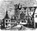
Týn Castle (1868)
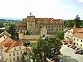
Týn Castle
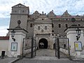
Týn Castle
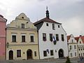
Town hall


References[]
- ^ "Population of Municipalities – 1 January 2021". Czech Statistical Office. 2021-04-30.
- ^ Jump up to: a b c "Historie" (in Czech). Město Horšovský Týn. Retrieved 2021-06-12.
- ^ "Partnerská města" (in Czech). Město Horšovský Týn. Retrieved 2020-04-08.
External links[]
| Wikimedia Commons has media related to Horšovský Týn. |
| show Authority control |
|---|
- Horšovský Týn
- Cities and towns in the Czech Republic
- Populated places in Domažlice District