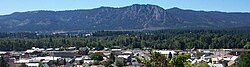
Cle Elum, Washington
Cle Elum, Washington | |
|---|---|
 | |
| Motto(s): "Heart of The Cascades" | |
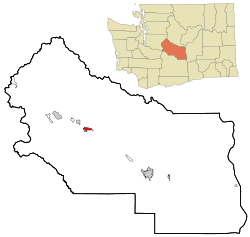 Location of Cle Elum in Washington State | |
| Coordinates: 47°11′42″N 120°56′20″W / 47.195°N 120.939°WCoordinates: 47°11′42″N 120°56′20″W / 47.195°N 120.939°W | |
| Country | United States |
| State | Washington |
| County | Kittitas |
| Founded | February 12, 1902 |
| Area | |
| • City | 4.50 sq mi (11.65 km2) |
| • Land | 4.49 sq mi (11.63 km2) |
| • Water | 0.01 sq mi (0.01 km2) |
| Elevation | 1,909 ft (582 m) |
| Population | |
| • City | 1,872 |
| • Estimate (2019)[2] | 2,037 |
| • Density | 453.57/sq mi (175.12/km2) |
| • Metro | 41,765 |
| Time zone | UTC-8 (PST) |
| • Summer (DST) | UTC-7 (PDT) |
| ZIP code | 98922 |
| Area code(s) | 509 |
| FIPS code | 53-12945 |
| GNIS feature ID | 1517819[4] |
| Website | City of Cle Elum |

Cle Elum (/kli ˈɛləm/ klee ELL-um) is a city in Kittitas County, Washington, United States. The population was 1,872 at the 2010 census.[5] About 96 miles (154 km) by car from Seattle, Cle Elum is a popular area for camping and outdoor activities.
History[]
Early years and industries[]
Some[who?] assert that the selection of the Stampede Pass was determined by the coal discovery[clarification needed]. In the spring of 1886 the railroad engineers under Mr. Virgil Bogue and Mr. Herbert Huson were making their survey through the region with the intent of establishing a station. At the site of the future city, a Northern Pacific Railway station was named Clealum after the name Tle-el-Lum (tlielləm), meaning "swift water", referring to the Cle Elum River. Maps of the United States Postal Guide used two words while other early maps show it as one word: Clealum.[6] In 1908, Clealum was altered to Cle Elum.[7] The name was given to the river, the city, and Cle Elum Lake. Walter Reed entered into a partnership with Thomas Johnson of Ellensburg and laid out sixty-five acres as a site. This was legally dedicated on July 26, 1886. Mr. Johnson had owned a sawmill on Wilson Creek, in Grant County and he moved the mill to the new location in the vicinity of the new town. The partners, Reed and Johnson, established what was undoubtedly the largest mill up to that time in central or Eastern Washington, cutting 40,000 feet of board lumber per day. At the same time, Frederick Leonhard, who, with his brother-in-law, Gerrit d'Ablaing, had been carrying on a mill on Cooke Creek and later on the Naneum, moved to the vicinity of Cle Elum. They cut a large part of the lumber for the Stampede Tunnel.
The early 20th century[]
Cle Elum was officially incorporated on February 12, 1902.
Tragedy struck the area when on July 16, 1908, two carloads of blasting powder being unloaded by the Northwest Improvement Company exploded, killing at least nine people including miners, NIC store employees and a family with children living in a tent near the building. The explosion, located about three-quarters of a mile from Cle Elum's downtown, scattered debris and human remains and shattered windows across town. Accounts from residents equated the explosion to an earthquake.[8]
In December 1910, loggers working for the Cascade Lumber Company near Cle Elum went on strike after the company reduced pay and began charging $5 per week for board. (equivalent to $139 in 2020)[9][10][11]
In 1913, steps were taken to improve automobile access across the Cascade Mountains via Snoqualmie Pass. A $1,500,000 levy (equivalent to $39,300,000 in 2020) was approved in 1913 to improve and expand the state's highways. The majority[clarification needed] of the levy ($590,743) went to construction of the Sunset Highway between Spokane and Seattle. This major cross-state highway would pass directly through Cle Elum's business district, and as it was one of the first towns reached after traveling east across the pass, would greatly benefit from its construction.[12] That same year, reflecting on the prosperity of the coal mines, the city's second bank was chartered.[13] By 1914, Cle Elum's population had risen to 3,000 from about 100 at the turn of the 20th century.[14]
Great fire of 1918[]
Cle Elum's greatest disaster occurred on June 25, 1918, when a huge fire wiped out over seventy acres of the city (29 city blocks) causing over $500,000 (about $8.6 million today) in damages. The cause was later determined to most likely to be a cigarette butt thrown into a pile of garbage behind a theater. Thirty businesses and 205 houses were destroyed, leaving more than 1,800 people homeless. Following the incident, aid from across the state began pouring in. The Red Cross brought tents from Camp Lewis to house displaced citizens while soldiers were sent from Ellensburg to guard businesses. Yakima and Portland also sent aid to the city. No lives were lost in the incident.[15]
High insurance rates on Cle Elum's many wooden structures inhibited many people from purchasing them. One of the few buildings in downtown Cle Elum to survive the fire was the Cle Elum State Bank Building, built in 1906; it still stands today. The rest of downtown was quickly rebuilt with brick and many of these buildings still stand.
Geography[]
Cle Elum is located 71 miles (114 km) ESE of Seattle, 45 miles (73 km) NNW of Yakima, and 35 miles (56 km) WSW of Wenatchee.
According to the United States Census Bureau, the city has a total area of 3.83 square miles (9.92 km2), of which 3.82 square miles (9.89 km2) is land and 0.01 square miles (0.03 km2) is water.[16] It borders South Cle Elum and Roslyn.
Climate[]
Cle Elum has a humid continental climate, Köppen subtype Dsb. The elevation is 1909 feet and temperatures are cooler than areas to the west. The coldest month is December, a trait common in the Pacific Northwest. But hot temperatures still occur, and not just in summer: on March 18, 1968, the temperature soared to 95 °F.[17]
The climate has warmed in tandem with surrounding areas; climate data further back shows that winters were once colder, and that January was historically the coldest month.[18]
| hideClimate data for Cle Elum, Washington | |||||||||||||
|---|---|---|---|---|---|---|---|---|---|---|---|---|---|
| Month | Jan | Feb | Mar | Apr | May | Jun | Jul | Aug | Sep | Oct | Nov | Dec | Year |
| Record high °F (°C) | 65 (18) |
69 (21) |
95 (35) |
96 (36) |
99 (37) |
100 (38) |
105 (41) |
105 (41) |
98 (37) |
96 (36) |
68 (20) |
66 (19) |
105 (41) |
| Average high °F (°C) | 36 (2) |
41 (5) |
50 (10) |
57 (14) |
65 (18) |
71 (22) |
80 (27) |
80 (27) |
73 (23) |
58 (14) |
43 (6) |
33 (1) |
57 (14) |
| Average low °F (°C) | 24 (−4) |
24 (−4) |
30 (−1) |
34 (1) |
41 (5) |
47 (8) |
53 (12) |
52 (11) |
43 (6) |
34 (1) |
29 (−2) |
22 (−6) |
36 (2) |
| Record low °F (°C) | −33 (−36) |
−30 (−34) |
0 (−18) |
12 (−11) |
19 (−7) |
26 (−3) |
30 (−1) |
30 (−1) |
21 (−6) |
10 (−12) |
−14 (−26) |
−31 (−35) |
−33 (−36) |
| Average precipitation inches (mm) | 2.98 (76) |
2.66 (68) |
1.98 (50) |
1.07 (27) |
1.15 (29) |
0.89 (23) |
0.59 (15) |
0.50 (13) |
0.81 (21) |
1.91 (49) |
4.31 (109) |
3.50 (89) |
22.35 (569) |
| Source: [19] | |||||||||||||
Demographics[]
| Historical population | |||
|---|---|---|---|
| Census | Pop. | %± | |
| 1870 | 4 | — | |
| 1880 | 543 | 13,475.0% | |
| 1890 | 243 | −55.2% | |
| 1900 | 296 | 21.8% | |
| 1910 | 2,749 | 828.7% | |
| 1920 | 2,661 | −3.2% | |
| 1930 | 2,508 | −5.7% | |
| 1940 | 2,230 | −11.1% | |
| 1950 | 2,206 | −1.1% | |
| 1960 | 1,816 | −17.7% | |
| 1970 | 1,725 | −5.0% | |
| 1980 | 1,773 | 2.8% | |
| 1990 | 1,778 | 0.3% | |
| 2000 | 1,755 | −1.3% | |
| 2010 | 1,872 | 6.7% | |
| 2019 (est.) | 2,037 | [2] | 8.8% |
| Source:[20] 2015 Estimate[22] | |||
Since the 1980s, the Cle Elum area has become a satellite bedroom community for "super commuters" who work 85 miles (137 km) away in Seattle and other cities in the Puget Sound region.[23]
2010 census[]
As of the census[3] of 2010, there were 1,872 people, 857 households, and 500 families residing in the city. The population density was 490.1 inhabitants per square mile (189.2/km2). There were 1,105 housing units at an average density of 289.3 per square mile (111.7/km2). The racial makeup of the city was 92.1% White, 0.4% African American, 0.7% Native American, 1.0% Asian, 0.1% Pacific Islander, 1.7% from other races, and 4.0% from two or more races. Hispanic or Latino of any race were 5.8% of the population.
There were 857 households, of which 27.9% had children under the age of 18 living with them, 39.6% were married couples living together, 12.4% had a female householder with no husband present, 6.4% had a male householder with no wife present, and 41.7% were non-families. 34.2% of all households were made up of individuals, and 13.7% had someone living alone who was 65 years of age or older. The average household size was 2.18 and the average family size was 2.76.
The median age in the city was 41 years. 22% of residents were under the age of 18; 7.7% were between the ages of 18 and 24; 25.3% were from 25 to 44; 27.6% were from 45 to 64; and 17.4% were 65 years of age or older. The gender makeup of the city was 50.2% male and 49.8% female.
2000 census[]
As of the census of 2000, there were 1,755 people, 792 households, and 1448 families residing in the city. The population density was 1,182.8 people per square mile (457.8/km2). There were 956 housing units at an average density of 644.3 per square mile (249.4/km2). The racial makeup of the city was 95.16% White, 0.51% African American, 1.03% Native American, 0.57% Asian, 0.85% from other races, and 1.88% from two or more races. Hispanic or Latino of any race were 3.36% of the population.
There were 792 households, out of which 67.4% had children under the age of 18 living with them, 63.1% were married couples living together, 10.9% had a female householder with no husband present, and 43.4% were non-families. 35.4% of all households were made up of individuals, and 16.2% had someone living alone who was 65 years of age or older. The average household size was 2.22 and the average family size was 2.87.
In the city, the population was spread out, with 23.2% under the age of 18, 7.6% from 18 to 24, 26.7% from 25 to 44, 24.6% from 45 to 64, and 17.9% who were 65 years of age or older. The median age was 40 years. For every 100 females, there were 93.1 males. For every 100 females age 18 and over, there were 92.3 males.
The median income for a household in the city was $28,144, and the median income for a family was $39,000. Males had a median income of $32,750 versus $26,645 for females. The per capita income for the city was $16,620. About 17.4% of families and 20.8% of the population were below the poverty line, including 22.3% of those under age 18 and 18.5% of those age 65 or over.
Notable people[]
- Allen Larsen, ultramarathon cyclist
- Dick Scobee, astronaut killed in the Space Shuttle Challenger disaster
- Douglas Albert Munro, the first and only member of the U.S. Coast Guard to receive the Medal of Honor
- George Strugar, American football player
- Chuck Allen, American football player
References[]
- ^ "2019 U.S. Gazetteer Files". United States Census Bureau. Retrieved August 7, 2020.
- ^ Jump up to: a b "Annual Estimates of the Resident Population for Incorporated Places in Washington: April 1, 2010 to July 1, 2019". United States Census Bureau. May 2020. Retrieved May 27, 2020.
- ^ Jump up to: a b "U.S. Census website". United States Census Bureau. Retrieved 2012-12-19.
- ^ "Cle Elum". Geographic Names Information System. United States Geological Survey.
- ^ "2010 Census Redistricting Data (Public Law 94-171) Summary File". American FactFinder. United States Census Bureau. Retrieved 20 September 2012.[dead link]
- ^ Meany, Edmond S. (1923). Origin of Washington Geographic Names. University of Washington Press. p. 50. ISBN 9780598974808.
- ^ "Cle Elum". Washington Place Names database. Tacoma Public Library. Archived from the original on 2009-03-09. Retrieved 2009-03-05.
- ^ "Powder Blows Bodies to Bits; Magazine explodes near Cle Elum Wash. The Oregonian 17 July 1908.
- ^ 1634 to 1699: McCusker, J. J. (1992). How Much Is That in Real Money? A Historical Price Index for Use as a Deflator of Money Values in the Economy ofthe United States: Addenda et Corrigenda (PDF). American Antiquarian Society. 1700-1799: McCusker, J. J. (1992). How much is that in real money?: a historical price index for use as a deflator of money values in the economy of the United States (PDF). American Antiquarian Society. 1800–present: Federal Reserve Bank of Minneapolis. "Consumer Price Index (estimate) 1800–". Retrieved January 1, 2020.
- ^ Upton, Austin. "IWW Yearbook 1910". IWW History Project. University of Washington. Retrieved 19 April 2016.
- ^ Robertson (6 December 1910). "Strike On: Help Out the Loggers". Industrial Worker. 2 (39) (published 15 December 1910). p. 4.
- ^ "Good Roads O. K.' D. in Record Time. Washington Legislature Brings Fight to Peaceable Termination" The Oregonian 04 Mar. 1913.
- ^ "Cle Elum Bank Charter Approved" The Oregonian 22 Nov. 1913.
- ^ "From Town of 100 Cle Elum Has 3000. Progressive Little Mining and Lumber City in Washington Grows Fast" The Oregonian 6 Aug. 1914.
- ^ "City Of Tents Is Rising American Red Cross Sends Shelters From Camp Lewis" The Oregonian 28 Jun. 1918.
- ^ "US Gazetteer files 2010". United States Census Bureau. Archived from the original on 2012-07-02. Retrieved 2012-12-19.
- ^ https://wrcc.dri.edu/cgi-bin/cliGCStT.pl?wa1504
- ^ https://wrcc.dri.edu/cgi-bin/cliMAIN.pl?wa1504
- ^ "weather.com". Retrieved November 15, 2011.
- ^ Moffatt, Riley. Population History of Western U.S. Cities & Towns, 1850-1990. Lanham: Scarecrow, 1996, 316.
- ^ United States Census Bureau. "Census of Population and Housing". Retrieved July 21, 2014.
- ^ "Population Estimates". United States Census Bureau. Archived from the original on October 19, 2016. Retrieved July 10, 2016.
- ^ Clutter, Stephen (February 16, 1998). "85 miles: That's a commute". The Seattle Times. p. A1. Retrieved April 12, 2020.
- Lyman, W.D. (1919). History of the Yakima Valley, Washington, Comprising Yakima, Kittitas and Benton Counties. The S.J. Clarke Publishing Co. pp. 762–777.
 This article includes a list of general references, but it remains largely unverified because it lacks sufficient corresponding inline citations. (May 2013)
External links[]
- City of Cle Elum website
- Cle Elum Visitor Center
- Cle Elum Roslyn School District
- Futurepast, publisher of Coal Towns in the Cascades, A Centennial History of Roslyn and Cle Elum, Washington, 2nd Edition, by John C. Shideler
- CWU Brooks Library and Ellensburg Public Library's historic local photographs collection[permanent dead link] A collection of 294 historic photographs dating from the late 19th century to the early 20th century. The collection consists of photographic images of buildings, street scenes and town views of Ellensburg and the other communities in Kittitas County
- City of Cle Elum Library (Carpenter Memorial Library)
- The chimp sanctuary for "The Cle Elum Seven", 7 former lab animals
| show Municipalities and communities of Kittitas County, Washington, United States |
|---|


| show Places adjacent to Cle Elum, Washington |
|---|
| show Authority control |
|---|
- Cities in Washington (state)
- Cities in Kittitas County, Washington
- Populated places on the Yakima River