Coron Island
 Coron Island Cove | |
 Coron Island Location within the Philippines | |
| Geography | |
|---|---|
| Coordinates | 11°55′45″N 120°14′30″E / 11.92917°N 120.24167°ECoordinates: 11°55′45″N 120°14′30″E / 11.92917°N 120.24167°E |
| Archipelago | Calamian Group of Islands |
| Adjacent bodies of water | Sulu Sea |
| Area | 71 km2 (27 sq mi) |
| Length | 20 km (12 mi) |
| Width | 9 km (5.6 mi) |
| Highest elevation | 600 m (2000 ft)[1] |
| Administration | |
| Region | Mimaropa |
| Province | Palawan |
| Municipality | Coron |
| Demographics | |
| Population | 2649 (2010)[2] |

Coron is the third-largest island in the Calamian Islands in northern Palawan in the Philippines. The island is part of the larger municipality of the same name. It is about 170 nautical miles (310 km) southwest of Manila and is known for several Japanese shipwrecks of World War II vintage. Because of its unique ecological features, the entire area is protected by several legal proclamations.[1]
The island and surrounding fishing grounds are part of the ancestral domain of the indigenous Tagbanwa people, officially designated such on June 5, 1998.[1] Known as Calis among the Tagbanwas and Coronians, its tribal chieftain is Rodolfo Aguilar I.
The island comprises two barangays of the municipality of Coron: Banuang Daan and Cabugao.[1]
Geography[]
Partially between Busuanga and Culion islands, Coron Island faces the Sulu Sea and forms the eastern side of Coron Bay. It is about 20 kilometres (12 mi) long from north to south, and 9 kilometres (5.6 mi) at its widest point.
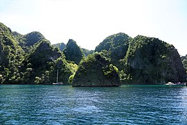
It is a wedge-shaped mountainous island, dominated by steep cliffs and Karst rock formations made of Permian limestone of Jurassic origin[clarification needed] that comprises about 70% of its area. Another 25% is rolling hills, while only 5% is relatively flat. There are 11 lakes nestled in the rugged terrain, of which three have underground connections to the sea. There are a few mangroves in coastal areas.[1]
Diving[]
The area around the wrecks has rock formations which provide for snorkeling opportunities, with underwater visibility extending up to 80 feet (24 m). The water is often calm. Coron is one of the most visited destinations for wreck diving in the Philippines.[citation needed] Wreck dive sites are found in depths as shallow as 10–30 feet (3.0–9.1 m) and as deep as 120–140 feet (37–43 m). Most are in the range of about 60–80 feet (18–24 m).
Dive sites around Coron include many different reef dive sites and "Günter's Cave", also known as Cathedral Cave because during a certain time of the day, the sun throws a beam of light through a hole in the cave ceiling, illuminating the inside. It is possible to surface in the cave, as the hole in the cave-ceiling allows fresh air to enter. The cave is named after Günther Bernert, who was part of the first dive group to explore the cave, after hearing from local fishermen about its existence.[citation needed]
Wreck diving sites in Coron Bay include the Akitsushima, Irako, Kogyo Maru, Kyokuzan Maru, Nanshin Maru, Okikawa Maru, Olympia Maru, Lusong Gunboat, East Tangat gunboat (the name of the ship, Terukaze Maru, was recently discovered by a group of Dutch divers, who spent a couple of days digging into bottom sand around the stern), and 'Skeleton' Wrecks.[citation needed]
The aquatic views from the sunken Japanese ships off Coron Island are listed in Forbes Traveler Magazine's top-10 best scuba diving sites in the world.[3][4]
Other points of interest[]
Ecotourism has long surpassed diving as the top draw to Coron Island in the last decade. With domestic tourism on the rise due to a rapidly growing middle class, Coron is one of the top destinations for Filipinos to add to their wish list, with Coron Island containing some of the most iconic.
Gallery[]

The Twin Lagoon in Coron Island

Large rock formations at the Barracuda Lake

Banol beach on Coron Island
Coron Island rock formations
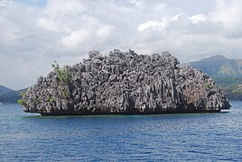
A stone islet in Coron Island
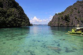
The bay near Kayangan Lake


See also[]
References[]
- ^ Jump up to: a b c d e "Coron Island Natural Biotic Area". World Heritage Centre: Tentative lists. UNESCO. Retrieved 16 February 2016.
- ^ "Total Population by Province, City, Municipality and Barangay: as of May 1, 2010" (PDF). 2010 Census of Population and Housing. National Statistics Office. Archived from the original (PDF) on 15 November 2012. Retrieved 16 February 2016.
- ^ "Manila Standard". Retrieved 20 April 2017.
- ^ "canada.com - Page Not Found". Retrieved 20 April 2017 – via Canada.com. Cite uses generic title (help)
- ^ "Get the important info on Kayangan Lake before you go". Unofficialguide.ph. Retrieved 20 September 2018.
- ^ "Photo Story: Barracuda Lake". Unofficialguide.ph. Retrieved 25 September 2018.
- ^ "Photo Story: Coron's Amazing Twin Lagoons". Unofficialguide.ph. Retrieved 23 September 2018.
- ^ Ferdz (11 July 2008). "Coron: Scenic Kayangan Lake". Retrieved 20 April 2017.
- ^ "Kayangan Lake (Coron, Philippines): Top Tips Before You Go - TripAdvisor". Retrieved 20 April 2017.
External links[]
![]() Media related to Coron Island at Wikimedia Commons
Media related to Coron Island at Wikimedia Commons
![]() Coron travel guide from Wikivoyage
Coron travel guide from Wikivoyage
| show The 40 largest islands of the Philippines |
|---|
- Calamian Islands
- Underwater diving sites in the Philippines
- Tourist attractions in Palawan
- World Heritage Tentative List for the Philippines