Cranston, Rhode Island
Cranston, Rhode Island | |
|---|---|
City | |
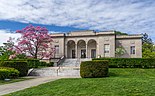
The William Hall Library, Rosedale Apartments, Pawtuxet Village, the Furnace Hill Brook Historic and Archeological District | |
 Seal | |
 Location in Providence County and the state of Rhode Island. | |
| Coordinates: 41°46′N 71°27′W / 41.767°N 71.450°WCoordinates: 41°46′N 71°27′W / 41.767°N 71.450°W | |
| Country | United States |
| State | Rhode Island |
| County | Providence |
| Incorporated (town) | 1754 |
| Incorporated (city) | 1910[1] |
| Government | |
| • Type | Mayor-council |
| • Mayor | Kenneth Hopkins (R) |
| • City Council | Nicole Renzulli (R) Jessica Marino (D) Robert Ferri (R) Lammis J. Vargas (D) Aniece Germain (D) John P. Donegan (D) Edward J. Brady (R) Christopher G. Paplauskas (R) Matthew Reilly (R) |
| Area | |
| • Total | 30.02 sq mi (77.75 km2) |
| • Land | 28.34 sq mi (73.41 km2) |
| • Water | 1.67 sq mi (4.33 km2) |
| Elevation | 62 ft (19 m) |
| Population (2010) | |
| • Total | 80,387 |
| • Estimate (2019)[3] | 81,456 |
| • Density | 2,873.73/sq mi (1,109.55/km2) |
| Time zone | UTC−5 (EST) |
| • Summer (DST) | UTC−4 (EDT) |
| ZIP Codes | 02823, 02905, 02907, 02910, 02920, 02921 |
| Area code(s) | 401 |
| FIPS code | 44-19180[4] |
| GNIS feature ID | 1218689[5] |
| Website | www.cranstonri.com |


Cranston, once known as Pawtuxet, is a city in Providence County, Rhode Island, United States. The official population of the city in the 2020 United States Census was 82,934, making it the second largest in the state. The center of population of Rhode Island is located in Cranston.[6] Cranston is a part of the Providence metropolitan area.
Cranston was named one of the "100 Best Places to Live" in the United States by Money magazine in 2006.[7] It is among the top 25 safest cities in the country, according to CQ Press's research.[citation needed] Cranston ranked 36th on the list of “America’s 50 Best Cities to Live” in a 2014 survey done by 24/7 Wall St.[8]
The Town of Cranston was created in 1754 from a portion of Providence north of the Pawtuxet River. After losing much of its territory to neighboring towns and the city of Providence, Cranston itself became a city on 10 March 1910.
History[]
Much of the land was purchased by Roger Williams from the Narragansett Indians in 1638 as part of the Pawtuxet Purchase, and the first settler in the area was William Arnold, who was followed shortly by William Harris, William Carpenter and Zachariah Rhodes.[9] Stephen Arnold, a brother-in-law of Rhodes and William Arnold, built a gristmill on the Pawtuxet falls and laid out the "Arnold Road" (modern-day "Broad Street") connecting it to the Pequot Trail leading to Connecticut. Arnold's son, Benedict Arnold, became the first Governor of Rhode Island under the charter of 1663. After area residents were unable to agree upon a name for a new town for decades, the Town of Cranston was eventually created by the General Assembly in 1754 from a portion of Providence north of the Pawtuxet River. Historians debate whether the town was named after Governor Samuel Cranston, the longest-serving Rhode Island governor or his grandson, Thomas Cranston, who was serving as Speaker of the Rhode Island House of Representatives at the time that the town was created. In the early 1770s town meetings were held at the taverns of Caleb Arnold and Nehemiah Knight where Cranstonians voted in favor of a resolution opposing the British Parliament's Coercive Acts, and the town heavily supported the Patriot cause during the Revolutionary War. After losing much of its territory to neighboring towns and the city of Providence over the nineteenth century, Cranston itself became a city on 10 March 1910.[10][11]
Many Italian-Americans in Cranston are descended from immigrants of Itri, Italy who settled mainly in the Knightsville section of Cranston during the early 1900s.[12] Cranston is known for the St. Mary's Feast, inspired by the Feast of the Madonna della Civita celebrated in Itri. Since 1905, the St. Mary's Feast has been a week-long festival celebrated in July in Cranston with vendors, a carnival, fireworks, and a religious procession from St. Mary's Church on Sunday.[13] In 2000, Cranston and Itri became sister cities.[14]
Flood of 2010[]
In March 2010, after an overwhelming amount of rain, the Pawtuxet River overflowed. This caused many major sites such as the Warwick Mall, Contour Dental Laboratories, and the CLCF Building to be shut down and repaired.[15]
Geography[]
According to the United States Census Bureau, the city has a total area of 29.9 square miles (77 km2), of which, 28.6 square miles (74 km2) of it is land and 1.4 square miles (3.6 km2) of it (4.54%) is water.
It is roughly three percent of Rhode Island's total land mass.[16]
The following neighborhoods and villages are located in Cranston:
- Alpine Estates
- Apple Hill Estates
- Arlington
- Bellefonte
- Castleton Estates
- Auburn
- Dean Estates
- Eden Park
- Edgewood
- Fiskeville (also in Scituate)
- Forest Hills
- Friendly Community
- Garden City
- Garden Hills
- Glen Woods
- Hillside Farms
- Laurel Hill
- Howard
- Jackson (also in Scituate)
- Knightsville
- Meshanticut
- Oakhill Terrace
- Oaklawn
- Orchard Valley Estates
- Pontiac
- Stadium
- Thornton (this includes part of Johnston)
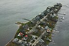
- Pawtuxet Village (also in Warwick)
- Webster
- Westend
- Woodridge
- Western Hills Village
Demographics[]
| Historical population | |||
|---|---|---|---|
| Census | Pop. | %± | |
| 1790 | 1,990 | — | |
| 1800 | 1,644 | −17.4% | |
| 1810 | 2,161 | 31.4% | |
| 1820 | 2,274 | 5.2% | |
| 1830 | 2,653 | 16.7% | |
| 1840 | 2,902 | 9.4% | |
| 1850 | 4,311 | 48.6% | |
| 1860 | 7,500 | 74.0% | |
| 1870 | 4,822 | −35.7% | |
| 1880 | 5,940 | 23.2% | |
| 1890 | 8,099 | 36.3% | |
| 1900 | 13,343 | 64.7% | |
| 1910 | 21,107 | 58.2% | |
| 1920 | 29,407 | 39.3% | |
| 1930 | 42,911 | 45.9% | |
| 1940 | 47,085 | 9.7% | |
| 1950 | 55,060 | 16.9% | |
| 1960 | 66,766 | 21.3% | |
| 1970 | 74,287 | 11.3% | |
| 1980 | 72,534 | −2.4% | |
| 1990 | 75,043 | 3.5% | |
| 2000 | 79,269 | 5.6% | |
| 2010 | 80,387 | 1.4% | |
| 2020 | 82,934 | 3.2% | |
| U.S. Decennial Census[17] | |||
2010[]
As of the 2010 US Census, there were 80,387 people living in the city. The racial makeup of the village was 81.93% White, 5.26% African American, 0.32% Native American, 5.17% Asian, 0.06% Pacific Islander, 4.6% from other races, and 2.66% from two or more races. Hispanic or Latino of any race were 10.83% of the population.
2010 census[]
As of the census[4] of 2010, there were 79,269 people, 30,954 households, and 20,243 families living in the city of Cranston. The population density was 2,774.6 persons per square mile (1,071.3/km2). There were 32,068 housing units at an average density of 1,122.5 per square mile (433.4/km2). The racial makeup of the city was 89.19% White, 3.69% African American, 0.30% Native American, 3.28% Asian, 0.04% Pacific Islander, 1.93% from other races, and 1.57% from two or more races. Hispanic or Latino of any race were 4.56% of the population.
There were 30,954 households, out of which 28.7% had children under the age of 18 living with them, 49.2% were married couples living together, 12.5% had a female householder with no husband present, and 34.6% were non-families. 29.4% of all households were made up of individuals, and 13.1% had someone living alone who was 65 years of age or older. The average household size was 2.41 and the average family size was 3.01.
In the city the population was spread out, with 21.6% under the age of 18, 7.7% from 18 to 24, 31.5% from 25 to 44, 22.0% from 45 to 64, and 17.3% who were 65 years of age or older. The median age was 39 years. For every 100 females, there were 95.9 males. For every 100 females of age 18 or over, there were 92.8 males.
The median income for a household in the city was $44,108, and the median income for a family was $55,241. Males had a median income of $40,031 versus $28,279 for females. The per capita income for the city was $21,978. About 5.6 of families and 7.3% of the population were below the poverty line, including 8.6% of those under the age of 18 and 8.5% of those ages 65 or older.
Economy[]
This section needs expansion. You can help by . (April 2016) |
Companies with corporate headquarters in Cranston include jewelry maker Alex and Ani and Coastway Community Bank. The first Del's Lemonade stand was opened in Cranston in 1948.[18]
Arts and culture[]
Sites[]

The first auto race track in the country, Narragansett Park[a], located off Park Avenue, opened at present-day Stadium Ball Field in September 1886 as a trotting track.[19]
Cranston is home to the Budlong Pool, one of the largest outdoor swimming pools in the country. Built in the 1940s as a Works Progress Administration project, it is a staple of the community. It is located at 198 Aqueduct Road, off Reservoir Avenue (part of RI 2).
Sprague Mansion, an 18th-century homestead, is listed on the National Register of Historic Places.[20] The Thomas Fenner House, built around 1677, is one of the oldest houses in Rhode Island. Edgewood Yacht Club which is no longer standing was a notable structure on the National Register of Historic Places located on the Providence River.
Sports[]
Little League[]
- 1996 United States Champions (CWLL)
- 2015 New England Champions (CWLL)
Government[]
The Rhode Island Department of Corrections has its headquarters and its adult prison facilities in Cranston.[21] The Rhode Island Department of Children, Youth & Families operates the Rhode Island Training School (RITS), a juvenile correctional facility, in Cranston. The Rhode Island Division of Motor Vehicles is headquartered in Cranston.[22]
The City of Cranston operates under a mayor-council form of government. General city elections are held on the first Tuesday in November of every even-numbered year. Terms for elected officials begin on the first Monday in January of the year following their election.[23] The City Council consists of nine members: six representing each of the City wards, and three citywide representatives. Council members are elected to a two-year term, and are limited to five consecutive two-year terms.[24] The current Cranston City Council President is Christopher Paplauskas and the council has a Republican majority.
The current mayor, Kenneth Hopkins, was sworn in on January 4, 2021. Former mayor Allan Fung, the city's first Asian American mayor, was expected to attend but unexpectedly contracted COVID-19. As of 2012, mayors may be elected to no more than two consecutive four-year terms.[24][25]
In the Rhode Island Senate, Cranston is split into four senatorial districts, all represented by Democrats: Frank S. Lombardi (District 26), Hanna M. Gallo (District 27), Joshua Miller (District 28), and Kendra Anderson (District 31). At the federal level, Cranston is a part of Rhode Island's 2nd congressional district and is currently represented by Democrat James R. Langevin.
In presidential elections, Cranston is reliably Democratic as no Republican presidential nominee has won the city in over three decades.
| Year | GOP | DEM | Others |
|---|---|---|---|
| 2020 | 42.22% 17,313 | 56.12% 23,039 | 1.71% 701 |
| 2016 | 43.30% 15,934 | 50.99% 18,763 | 5.70% 2,099 |
| 2012 | 37.20% 13,008 | 61.16% 21,388 | 1.64% 574 |
| 2008 | 37.72% 13,981 | 60.76% 22,520 | 1.51% 561 |
| 2004 | 40.95% 14,471 | 57.54% 20,331 | 1.51% 532 |
| 2000 | 31.00% 10,420 | 63.09% 21,204 | 5.90% 1,984 |
| 1996 | 26.71% 9,098 | 61.37% 20,901 | 11.92% 4,059 |
| 1992 | 31.45% 12,450 | 46.96% 18,589 | 21.59% 8,549 |
| 1988 | 46.33% 17,129 | 53.32% 19,711 | 0.35% 128 |
Education[]
- Cranston High School East
- Cranston High School West
- Cranston Area Career And Technical Center
- Western Hills Middle School
- Hugh B. Bain Middle School
- Park View Middle School
- Hope Highlands Middle School
- Arlington Elementary School
- Chester Barrows Elementary School
- William Dutemple Elementary School
- Eden Park Elementary School
- Edgewood Highlands Elementary School
- Garden City Elementary School
- Gladstone Elementary School
- Glen Hills Elementary School
- Oaklawn Elementary School
- Orchard Farms Elementary School
- George J. Peters Elementary School
- Edward S. Rhodes Elementary School
- Stadium Elementary School
- Stone Hill Elementary School
- Daniel D. Waterman Elementary School
- Woodridge Elementary School
School Committee[]
The Cranston Public Schools School Committee consists of seven members; six representing each of the city wards and one citywide representative. Committee members are elected to a two-year term, and as of 2014, members are limited to five consecutive two-year terms.[27]
Infrastructure[]
Transportation[]
Four freeways travel through Cranston: I-95, I-295, RI 10 (the Huntington Expressway) and RI 37. Other state-numbered roads in Cranston are U.S. 1, US 1A, RI 2, RI 5, RI 12, RI 33, RI 51, RI 115 and RI 117.
Cranston is served by Rhode Island Public Transit Authority (RIPTA) buses. Amtrak's Northeast Corridor passes through but has no station in the city. The MBTA's Providence/Stoughton Line also passes through but does not include a station in Cranston. However, a station stop has been proposed. Currently, the nearest MBTA stations are in Providence and Warwick at T.F. Green Airport, the former which is also served by Amtrak.
Notable people[]
In popular culture[]
- Seth MacFarlane, creator of the animated sitcom Family Guy, said in an interview with a news program on WNAC-TV, Channel 64 in Providence, that the town named "Quahog" in the show is modeled after Cranston, Rhode Island.[28]
Sister cities[]
 Itri, Lazio, Italy
References[]
- ^ Not to be confused with Narragansett Park a Thoroughbred horse track, located in Pawtucket, RI, which closed in 1978.
- ^ "Cranston Rhode Island, United States". Encyclopedia britannica. Retrieved 6 November 2019.
- ^ "2019 U.S. Gazetteer Files". United States Census Bureau. Retrieved July 29, 2020.
- ^ "Population and Housing Unit Estimates". United States Census Bureau. May 24, 2020. Retrieved May 27, 2020.
- ^ Jump up to: a b "U.S. Census website". United States Census Bureau. Retrieved 2008-01-31.
- ^ "US Board on Geographic Names". United States Geological Survey. 2007-10-25. Retrieved 2008-01-31.
- ^ "Geography Program". Archived from the original on 2013-07-05. Retrieved 2008-12-04.
- ^ "MONEY Magazine: Best places to live 2006: Cranston, RI snapshot". Money.cnn.com. Retrieved 2009-12-11.
- ^ "America's 50 Best Cities to Live". 247wallst.com. Retrieved 2014-09-17.
- ^ Moyer, Sandra M.; Worthington, Thomas A. (2014). Cranston Revisited. Arcadia Publishing. ISBN 9781467120791.
- ^ Steven Frias, Cranston and Its Mayors: A History (The History Press, 2011) pg. 10-20
- ^ Historic District Commission "History of Cranston" http://www.cranstonri.com/generalpage.php?page=94 Archived 2009-01-03 at the Wayback Machine
- ^ Fuoco, Joe; Lothrop, A. J. (1998). Knightsville and Silver Lake. Arcadia Publishing. ISBN 978-0-7524-1229-0.
- ^ Kittredge, Daniel. "Set for 110th year, St. Mary's Feast renews focus on religious roots". Cranston Herald. Retrieved 2019-10-26.
- ^ Schiff, Pam. "Mayor of Itri greeted warmly, now he has the city key". Cranston Herald. Retrieved 2019-10-26.
- ^ [=https://www.youtube.com/watch?v=2Nf_Mt8t_wo "WPRO Newscast"] Check
|url=value (help). - ^ Tempera, Jacqueline (10 April 2016). Phipps, Peter (ed.). "Rhode Island is small, but not that small". Tampa Bay Times. Retrieved 11 April 2016.
- ^ "Census of Population and Housing". Census.gov. Retrieved June 4, 2015.
- ^ http://dels.com/about-us/ Retrieved December 27, 2016.
- ^ Crazy Good: The True Story of Dan Patch, the Most Famous Horse in America by Charles Leerhsen
- ^ "Sprague Mansion, Cranston, RI". Riroads.com. Archived from the original on 2006-03-26. Retrieved 2009-12-11.
- ^ "Contact Us." Rhode Island Department of Corrections. Retrieved on December 7, 2009.
- ^ "DLLR's Division of Workforce Development and Adult Learning[permanent dead link]." Maryland Department of Labor, Licensing and Regulation. Retrieved on August 23, 2010.
- ^ "Municode Library". www.municode.com. Retrieved 2015-10-03.
- ^ Jump up to: a b "Municode Library". www.municode.com. Retrieved 2017-07-14.
- ^ Reynolds, Mark. "Fung tests positive for COVID-19, unable to swear in successor as Cranston mayor". The Providence Journal. Retrieved 2021-01-06.
- ^ "Rhode Island Board of Elections: Previous Election Results". Retrieved 2021-04-09.
- ^ "Municode Library". www.municode.com. Retrieved 2017-07-14.
- ^ "Family Guy writer at Bryant". The Providence Journal.
External links[]
| Wikivoyage has a travel guide for Cranston. |
| show Municipalities and communities of Providence County, Rhode Island, United States |
|---|


| show Narragansett Bay |
|---|

| Authority control |
|
|---|
- Cranston, Rhode Island
- Cities in Providence County, Rhode Island
- Populated coastal places in Rhode Island
- Providence metropolitan area
- Cities in Rhode Island