Deschambault-Grondines
Deschambault-Grondines | |
|---|---|
Municipality | |
 | |
 Location within Portneuf RCM | |
 Deschambault-Grondines Location in central Quebec | |
| Coordinates: 46°39′N 71°56′W / 46.650°N 71.933°WCoordinates: 46°39′N 71°56′W / 46.650°N 71.933°W[1] | |
| Country | Canada |
| Province | Quebec |
| Region | Capitale-Nationale |
| RCM | Portneuf |
| Constituted | February 27, 2002 |
| Government | |
| • Mayor | Gaston Arcand |
| • Federal riding | Portneuf—Jacques-Cartier |
| • Prov. riding | Portneuf |
| Area | |
| • Total | 152.00 km2 (58.69 sq mi) |
| • Land | 125.59 km2 (48.49 sq mi) |
| Population (2011)[3] | |
| • Total | 2,131 |
| • Density | 17.0/km2 (44/sq mi) |
| • Pop 2006–2011 | |
| • Dwellings | 1,043 |
| Time zone | UTC−5 (EST) |
| • Summer (DST) | UTC−4 (EDT) |
| Postal code(s) | G0A 1S0 |
| Area code(s) | 418 and 581 |
| Highways | |
| Website | www |

Deschambault-Grondines is a municipality of about 2100 inhabitants in the Canadian province of Quebec, located in Portneuf Regional County Municipality. The municipality was incorporated in 2002 by the merger of the formerly independent villages of Deschambault and Grondines.[4]
The name Grondines was named by Samuel de Champlain himself. "Grondines" is from the French verb "gronder", meaning to rumble or roar. In 1674, The Grondines windmill was built and is the oldest windmill in Québec. The windmill was first a flour mill, and then a lighthouse. In 1842 the church Saint-Charles-Borromée was built in Grondines. In 2006 the local Fromagerie des Grondines was built, it is an organic cheese farm open to the public.
Some of the famous people who lived here include filmmaker Denys Arcand, who was born in Deschambault.
Demographics[]
Population trend:[5]
- Population in 2011: 2131 (2006 to 2011 population change: 4.9%)
- Population in 2006: 2032
- Population total in 2001: 1965
- Deschambault: 1263
- Grondines: 702
- Population in 1996:
- Deschambault: 1240
- Grondines: 718
- Population in 1991:
- Deschambault: 1213
- Grondines: 654
Private dwellings occupied by usual residents: 951 (total dwellings: 1043)
Mother tongue:
- English as first language: 0%
- French as first language: 98.8%
- English and French as first language: 0%
- Other as first language: 1.2%
Points of interest[]
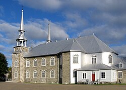
- Saint-Joseph of Deschambault church, classed historical monument in 1964.[6]
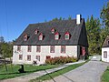
- The old presbytery of Deschambault, classed historical monument in 1965.
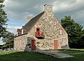
- The old mill of Grondines, classed archaeological monument in 1984.
- The church of Saint-Charles-Borromée in Grondines.
- Presbytery of Grondines, classed historical monument in 1966.
- House of the Grolo widow, classed historical monument in 1971.
- House of Delisle, classed historical monument in 1963.
- House of F.-R.-Neilson-Sewell, classed historical monument in 1978.
- The old Chevrotière Mill, classed historical monument in 1976.

The Saint-Joseph church was built between 1835 and 1839 according to the plans of the architect Thomas Baillairgé.
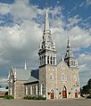
The Saint-Charles-Borromée church was built between 1839 and 1842 according to the plans of architect Thomas Baillairgé.
The old presbytery was built between 1815 and 1818.
The old mill was built in 1802 by Seigneur Joseph Chavigny de la Chevrotière.


Climate[]
| hideClimate data for Deschambault-Grondines | |||||||||||||
|---|---|---|---|---|---|---|---|---|---|---|---|---|---|
| Month | Jan | Feb | Mar | Apr | May | Jun | Jul | Aug | Sep | Oct | Nov | Dec | Year |
| Record high °C (°F) | 9.0 (48.2) |
9.0 (48.2) |
16.0 (60.8) |
30.5 (86.9) |
33.0 (91.4) |
34.5 (94.1) |
34.0 (93.2) |
34.4 (93.9) |
33.0 (91.4) |
26.0 (78.8) |
21.0 (69.8) |
13.0 (55.4) |
34.5 (94.1) |
| Average high °C (°F) | −7.3 (18.9) |
−5.0 (23.0) |
0.8 (33.4) |
9.1 (48.4) |
17.4 (63.3) |
22.8 (73.0) |
25.1 (77.2) |
24.1 (75.4) |
19.1 (66.4) |
11.5 (52.7) |
4.0 (39.2) |
−3.4 (25.9) |
9.9 (49.8) |
| Daily mean °C (°F) | −12.1 (10.2) |
−10.3 (13.5) |
−4.1 (24.6) |
4.3 (39.7) |
11.7 (53.1) |
16.9 (62.4) |
19.5 (67.1) |
18.6 (65.5) |
13.8 (56.8) |
7.2 (45.0) |
0.6 (33.1) |
−7.4 (18.7) |
4.9 (40.8) |
| Average low °C (°F) | −17 (1) |
−15.5 (4.1) |
−9.0 (15.8) |
−0.5 (31.1) |
5.9 (42.6) |
11.0 (51.8) |
13.9 (57.0) |
13.0 (55.4) |
8.5 (47.3) |
2.9 (37.2) |
−2.8 (27.0) |
−11.4 (11.5) |
−0.1 (31.8) |
| Record low °C (°F) | −38.5 (−37.3) |
−35 (−31) |
−31.5 (−24.7) |
−17.0 (1.4) |
−4.0 (24.8) |
−1.0 (30.2) |
3.0 (37.4) |
1.1 (34.0) |
−5.5 (22.1) |
−7.0 (19.4) |
−24.0 (−11.2) |
−35.0 (−31.0) |
−38.5 (−37.3) |
| Average precipitation mm (inches) | 77.0 (3.03) |
70.0 (2.76) |
69.1 (2.72) |
85.4 (3.36) |
100.5 (3.96) |
110.4 (4.35) |
125.5 (4.94) |
108.5 (4.27) |
116.5 (4.59) |
107.8 (4.24) |
95.6 (3.76) |
91.9 (3.62) |
1,158.1 (45.59) |
| Average rainfall mm (inches) | 26.3 (1.04) |
19.9 (0.78) |
31.5 (1.24) |
76.6 (3.02) |
99.7 (3.93) |
110.4 (4.35) |
125.5 (4.94) |
108.5 (4.27) |
116.5 (4.59) |
107.0 (4.21) |
74.1 (2.92) |
36.9 (1.45) |
932.8 (36.72) |
| Average snowfall cm (inches) | 50.7 (20.0) |
50.1 (19.7) |
37.6 (14.8) |
9.0 (3.5) |
0.8 (0.3) |
0.0 (0.0) |
0.0 (0.0) |
0.0 (0.0) |
0.0 (0.0) |
0.8 (0.3) |
21.5 (8.5) |
55.0 (21.7) |
225.5 (88.8) |
| Source: Environment Canada[7] | |||||||||||||
Miscellaneous[]
The patron saint of Deschambault-Grondines is Saint Joseph.[8]
References[]
- ^ Reference number 372307 of the Commission de toponymie du Québec (in French)
- ^ Jump up to: a b Ministère des Affaires municipales, des Régions et de l'Occupation du territoire - Répertoire des municipalités: Deschambault-Grondines Archived 25 June 2013 at the Wayback Machine
- ^ Jump up to: a b Statistics Canada 2011 Census - Deschambault-Grondines census profile
- ^ http://www.stat.gouv.qc.ca/publications/referenc/pdf/modfev02.pdf[permanent dead link]
- ^ Statistics Canada: 1996, 2001, 2006, 2011 census
- ^ Répertoire du patrimoine culturel du Québec
- ^ "Deschambault-Grondines Climate". Canadian Climate Normals 1981–2010 (in English and French). Environment Canada. Retrieved 16 July 2015.
- ^ Saint Joseph at sqpn.ocm Retrieved 5 April 2013
Further reading[]
- Mariages de Deschambault (comté Portneuf) - 1713-1900, raised by Rosaire Proulx priest, compiled and published by Benoit Pontbriand agronomist, 1966, 213 pages (in French)
External links[]
![]() Media related to Deschambault-Grondines at Wikimedia Commons
Media related to Deschambault-Grondines at Wikimedia Commons
| show Adjacent Municipal Subdivisions |
|---|
| hide | |
|---|---|
| Cities & towns | |
| Municipalities | |
| Parishes | |
| Unorganized territories | |
| |
| show Authority control |
|---|
- Municipalities in Quebec
- Incorporated places in Capitale-Nationale